


FS Navigation > Flight Simulator Navigation > Page 32
0.87Mb (155 downloads)
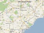
FSX Flight Plan for OB-17 Statesboro GA IFR high speed low altitude military training route. This is the second in a series of flight plans I will be uploading in the near future. These are great routes for B-52, F-111, B-1B, B-2 A6, A4, Vulcan and any fighter or bomber enthusiasts. Of course you can fly the route with any aircraft of your choice. Included in this package are two spectacular gauges by Karol Chlebowski for TFR flying and Pave Tack which includes many advanced features for bombing, navigation and reconnaissance. These two gauges will greatly enhance your ability to fly these challenging routes and are a great companion of the flight plans. Another option to download Version 2.1 of my mini panel which has all this functionality and more.
Posted Jul 8, 2011 21:22 by Bill McClellan
.jpg-thumb.jpg)
0.89Mb (148 downloads)
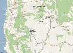
FSX Flight Plan for OB-11 Richmond KY Old IFR high speed low altitude military training route. This is the second in a series of flight plans I will be uploading in the near future. These are great routes for B-52, F-111, B-1B, B-2 A6, A4, Vulcan and any fighter or bomber enthusiasts. Of course you can fly the route with any aircraft of your choice. Included in this package are two spectacular gauges by Karol Chlebowski for TFR flying and Pave Tack which includes many advanced features for bombing, navigation and reconnaissance. These two gauges will greatly enhance your ability to fly these challenging routes and are a great companion of the flight plans. Another option to download Version 2.1 of my mini panel which has all this functionality and more.
Posted Jul 8, 2011 12:05 by Bill McClellan
0.92Mb (164 downloads)
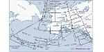
FSX Flight Plan for OB-1 Wilder Idaho IFR high speed low altitude military training route. This is the first in a series of flight plans I will be uploading in the near future. These are great routes for B-52, F-111, B-1B, B-2 A6, A4, Vulcan and any fighter or bomber enthusiasts. Of course you can fly the route with any aircraft of your choice. Included in this package are two spectacular gauges by Karol Chlebowski for TFR flying and Pave Tack which includes many advanced features for bombing, navigation and reconnaissance. These two gauges will greatly enhance your ability to fly these challenging routes and are a great companion of the flight plans. Another option to download Version 2.1 of my mini panel which has all this functionality and more.
Posted Jul 7, 2011 16:32 by Bill McClellan

0.00Mb (580 downloads)
This part one of the series of printable airport information. Information such as runways ILS, Radio and ATIS frequencies. On a printable sheet so you don't have to look this info up in FS. This file includes information for: Honolulu Intl, Los Angeles Intl (LAX), Kennedy Intl (JFK), San Francisco Intl, and San Diego Intl.
Posted Jun 30, 2011 09:19 by BOB
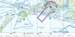
23.71Mb (434 downloads)
For use in any flight simulator.
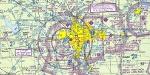
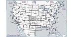
Hi-def scans of real VFR aeronautical United States charts, as available for download from the FAA, reduced and formatted in pdf form by me for use with flight sims. Display them in a kneeboard utility,print them, whatever...I like to use fragments of them to make pdfs for different flights, but that is only one way.
If you want to "get real" about navigating in the sim the way it's done in real life, these charts are for you. But you might also just enjoy wandering around, comparing the chart to the world depicted in the sim. These charts will most likely be outdated by the time you use them, or your sim may even pre-date the charts, but they should work well enough.
A basic guide for interpreting them is included, as well as tips on how to measure and mark them. Each chart also includes a handy chart legend, a map showing what region it covers, and airspace and frequency information.
If you are unfamiliar with how to use them for navigation, be sure to check out my multi-part tutorial series "Compass, Clock, and Chart", available here at simviation.com.
Posted May 6, 2011 16:08 by Sean Morrissey


25.39Mb (330 downloads)
Hi-def scans of real VFR aeronautical United States charts, as available for download from the FAA, reduced and formatted in pdf form by me for use with flight sims. Display them in a kneeboard utility,print them, whatever...I like to use fragments of them to make pdfs for different flights, but that is only one way.
If you want to "get real" about navigating in the sim the way it's done in real life, these charts are for you. But you might also just enjoy wandering around, comparing the chart to the world depicted in the sim. These charts will most likely be outdated by the time you use them, or your sim may even pre-date the charts, but they should work well enough.
A basic guide for interpreting them is included, as well as tips on how to measure and mark them. Each chart also includes a handy chart legend, a map showing what region it covers, and airspace and frequency information.
If you are unfamiliar with how to use them for navigation, be sure to check out my multi-part tutorial series "Compass, Clock, and Chart", available here at simviation.com.
Posted May 6, 2011 16:08 by Sean Morrissey

24.58Mb (329 downloads)
Hi-def scans of real VFR aeronautical United States charts, as available for download from the FAA, reduced
and formatted in pdf form by me for use with flight sims. Display them in a kneeboard utility,print them,
whatever...I like to use fragments of them to make pdfs for different flights, but that is only one way.
If you want to "get real" about navigating in the sim the way it's done in real life, these charts are for
you. But you might also just enjoy wandering around, comparing the chart to the world depicted in the sim.
These charts will most likely be outdated by the time you use them, or your sim may even pre-date the charts,
but they should work well enough.
A basic guide for interpreting them is included, as well as tips on how to measure and mark them. Each chart
also includes a handy chart legend, a map showing what region it covers, and airspace and frequency
information.
If you are unfamiliar with how to use them for navigation, be sure to check out my multi-part tutorial
series "Compass, Clock, and Chart", available here at simviation.com.
Posted May 6, 2011 01:40 by Sean Morrissey


23.66Mb (142 downloads)
Hi-def scans of real VFR aeronautical United States charts, as available for download from the FAA, reduced and formatted in pdf form by me for use with flight sims. Display them in a kneeboard utility,print them, whatever...I like to use fragments of them to make pdfs for different flights, but that is only one way.
If you want to "get real" about navigating in the sim the way it's done in real life, these charts are for you. But you might also just enjoy wandering around, comparing the chart to the world depicted in the sim. These charts will most likely be outdated by the time you use them, or your sim may even pre-date the charts, but they should work well enough.
A basic guide for interpreting them is included, as well as tips on how to measure and mark them. Each chart also includes a handy chart legend, a map showing what region it covers, and airspace and frequency information.
If you are unfamiliar with how to use them for navigation, be sure to check out my multi-part tutorial series "Compass, Clock, and Chart", available here at simviation.com.
Posted May 6, 2011 01:39 by Sean Morrissey

25.66Mb (145 downloads)
Hi-def scans of real VFR aeronautical United States charts, as available for download from the FAA, reduced and formatted in pdf form by me for use with flight sims. Display them in a kneeboard utility,print them, whatever...I like to use fragments of them to make pdfs for different flights, but that is only one way.
If you want to "get real" about navigating in the sim the way it's done in real life, these charts are for you. But you might also just enjoy wandering around, comparing the chart to the world depicted in the sim. These charts will most likely be outdated by the time you use them, or your sim may even pre-date the charts, but they should work well enough.
A basic guide for interpreting them is included, as well as tips on how to measure and mark them. Each chart also includes a handy chart legend, a map showing what region it covers, and airspace and frequency information.
If you are unfamiliar with how to use them for navigation, be sure to check out my multi-part tutorial series "Compass, Clock, and Chart", available here at simviation.com.
Posted May 6, 2011 01:38 by Sean Morrissey


22.97Mb (146 downloads)
Hi-def scans of real VFR aeronautical United States charts, as available for download from the FAA, reduced
and formatted in pdf form by me for use with flight sims. Display them in a kneeboard utility,print them,
whatever...I like to use fragments of them to make pdfs for different flights, but that is only one way.
If you want to "get real" about navigating in the sim the way it's done in real life, these charts are for
you. But you might also just enjoy wandering around, comparing the chart to the world depicted in the sim.
These charts will most likely be outdated by the time you use them, or your sim may even pre-date the charts,
but they should work well enough.
A basic guide for interpreting them is included, as well as tips on how to measure and mark them. Each chart
also includes a handy chart legend, a map showing what region it covers, and airspace and frequency
information.
If you are unfamiliar with how to use them for navigation, be sure to check out my multi-part tutorial
series "Compass, Clock, and Chart", available here at simviation.com.
Posted May 6, 2011 01:37 by Sean Morrissey