


0.02Mb (270 downloads)
Station Timeline
Squadron
Notes
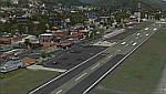
October 1943 Station opened.
November 1943 No.106 Sqn Operating the Avro Lancaster. The squadron disbanded at the station on the 18th February
1946.
September 1944 No.1690 BDT Operating the Supermarine Spitfire, Hawker Hurricane, Miles Martinet. The Bomber
Defence Training Flight left Metheringham on the 4th June 1945.
June 1945 No.467 (RAAF) Sqn Operating the Avro Lancaster. The squadron disbanded at the station on the 30th
September 1945.
October 1945 No.189 Sqn Operating the Avro Lancaster. The squadron disbanded on the 20th November 1945.
March 1946 Station ceased flying and put on Care and Maintenance.
March 1946 No.93 MU The Maintenance Unit left Metheringham in December 1950.
1951 RAF Metheringham closed.
1961-2 The airfield is sold-off
Posted Dec 12, 2015 18:50 by Terry Boissel
222.33Mb (1784 downloads)
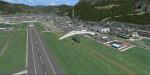
Photoreal scenery of the city of Bolzano (Italy) with seasonal and night textures. The scenery is compatible with the freeware scenery of Bolzano LIPB by Orbx.
Posted Dec 11, 2015 12:23 by Carlo Boninsegna

4.31Mb (302 downloads)
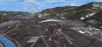
Avnoe Airbase on the southcoast of sealand was the home for Royal Danish Airforce flightschool founded in 1931 until the airbase were closed in 1993 and flightschool moved to EKKA Karup Airbase in jutland, where it still are.
This scenery covers the entire airbase area, some vegetation, animated windsock, animated gate (made of Bob Lacy), an animated flagpole made (of Dietmar Loleit), who also helped me with designing the airport sign outside the gate and warning signs on the fence around the airbase.
The scenery are made for FSX (DVD and Steam version).
Have tested it in P3D and it works there too, however some objects is missing,(the auto-gate and some signs and lights)
Posted Dec 11, 2015 06:52 by Otto R. Knudsen
19.75Mb (1789 downloads)
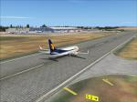
Goa International Airport, more commonly known as Dabolim Airport, is an international airport located in the city of Dabolim in Goa, India. It is the only airport in the state and operates as a civil enclave in a military airbase named INS Hansa. It is 4 km from the nearest city Vasco da Gama, 23 km from the South Goa district headquarters of Margao, and 30 km from the capital city Panjim.[4]
Terminal 1 - Domestic
Less than a dozen airlines compete in the domestic market. There are 132 airports in India which can be categorised in sometimes overlapping ways into public sector, private sector, civil enclaves, international, metro, and non-metro. Goa is connected to all six main cities in India: Mumbai, Bangalore, Hyderabad, Delhi, Chennai & Kolkata. There are multiple flights to Mumbai per day, operated by over 5 airlines. The first Goa - Mumbai domestic flight leaves at around 0700 in the morning and the last flight leaves at around 2350.
Terminal 2 - International. There are two versions for Goa International airport included in this package. One with the old ICAO code and then
the other with the new ICAO code. The new coded airport scenery has no AI traffic.
- If you decide to use the VOGO scenery then, you will have to activate the dummy VAGO files as well.
- It is important to set the display scenery mesh resolution to at least 19m and the texture resolution to at least 60m. Failing to do so may result in unwanted terrain abnormalities.
-Alternate boundary texture to be used at your own risk. Only use if you know what you are doing.
This scenery was created with ADE9X, SbuilderX313, Gimp2.1, XML Marker, DXTBmp.
Posted Dec 11, 2015 02:14 by Ratan Lewis
0.02Mb (225 downloads)
Work started at RAF Manby in the mid thirties as part of the RAF Expansion scheme, however, it was not a typical station of the time in so much as it only supported two grass runways. This did not detract from it contribution to the war effort however. Opening in 1938 the unit will be remembered by many as a training station for armament officers, armourers swell as aircrew such as air gunners and bomb aimers. The station continued with its training role until its closure in 1974.
Posted Dec 10, 2015 18:54 by Terry Boissel
0.03Mb (283 downloads)
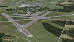
RAF Melbourne was a Royal Air Force station typical of the expansion period of the Second World War. Located 5
miles to the South-west of Pocklington, Yorkshire, England. The nearest village is Seaton Ross.
East Common just outside the village of Seaton Ross was requisitioned for use as a grass airfield in November
1940. In late 1940 the airfield was used by Armstrong Whitworth Whitleys of 10 Squadron as a relief landing ground
for RAF Leeming. The airfield soon closed for re-development as a standard Bomber Command airfield with three
concrete runways and three hangars.
The first user of the re-built airfield was again 10 Squadron but by this time operating the Handley Page Halifax
four-engined heavy bomber, little time was wasted before the aircraft were used on operational sorties from
Melbourne. The squadron continued with operation until March 1945 and lost 109 aircraft on operations.
Melbourne was unusually equipped with FIDO fog dispersant system. This made the airfield popular diversion
airfield for other squadrons returning from operations to Yorkshire.
In May 1945 the airfield was transferred to RAF Transport Command and 575 Squadron moved in with the Douglas
Dakota. The squadron only stayed for a few months operating transport flight to and from continental Europe. With
the departure of the Dakota a number of specialised Flights used the airfield for six months but by the middle of
1946 the airfield was no longer used for flying.
Source: Wikipedia
Posted Dec 9, 2015 20:57 by Terry Boissel
0.02Mb (252 downloads)
RAF Oulton is a former Royal Air Force Satellite airfield located 3 miles (4.8 km) west of Aylsham, Norfolk and
12.5 miles (20.1 km) northwest of Norwich, Norfolk, England.
The airfield was built over 1939 and 1940 as a bomber airfield with T2 type hangars and grass runways, the
facility operating as a satellite airfield of nearby RAF Horsham St. Faith between July 1940 and September 1942
after which it operated as a satellite airfield of RAF Swanton Morley.
In September 1943 Oulton was transferred from 2 Group to 3 Group and closed to flying for re-construction as a
heavy bomber base with concrete runways, taxiways and parking areas. The work was completed in April 1944 and the
airfield transferred to No. 100 Group RAF. Flying operations ceased at the end of July 1945, after which it was
taken over by RAF Maintenance Command which used it to store de Havilland Mosquitos until November 1947
Souce: Wikipedia
Posted Dec 9, 2015 20:03 by Terry Boissel
0.01Mb (246 downloads)
RAF North Witham is a former World War II airfield in Lincolnshire, England. The airfield is located in Twyford
Wood, off the A1 between Stamford and Grantham about 104 miles (167 km) north-northwest of London
Opened in 1943, it was used by both the Royal Air Force and United States Army Air Forces. During the war it was
used primarily as a transport airfield. After the war it was closed in late 1945.
Today the remains of the airfield are mostly woodland maintained by the Forestry Commission with the old concrete
runways still accessible.
Souce: Wikipedia
Posted Dec 9, 2015 19:01 by Terry Boissel
72.63Mb (1952 downloads)
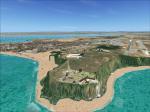
FSX/Prepar3D Scenery - Merida-SVMD (Sloped Runway)
SVMD is an airport located 3 km southwest of downtown Merida, Venezuela,
at an elevation of 1,526 m MSL. Its runway is 1,630 m long.
The runway has a gradient slope of +/- 4.05 %, for that reason,
this airport is the most difficult and dangerous to land in Venezuela.
It is situated in a valley in the Andean mountains, surrounded by higher terrain in all
quadrants. Night operations are prohibited
Runway 07 is used for landings only and Rwy 25 is used only
for take off.
Photo-terrain area improved with Autogen files.
Only compatible with versions to FSX or P3D v1 v2 v3 .x.
Also includes a friendly Auto-Install.
By David Maldonado
Posted Dec 9, 2015 14:54 by David Maldonado

78.19Mb (1133 downloads)
NAS Whiting field is the busiest Naval Air Station in the Navy. Approximately 40% of all Naval Aviators will recieve their primary Flight Training at Whiting Field. Whiting Field North caters to the fixed wing contingent and Whiting Field South serves rotary wing aviators in training. The base actually serves the Navy, Air Force, Coast Guards and Marines and has Water Towers representing the services served. Pilots fly the T34C Turbo Mentor, T-6A Texan II(future), and for rotary wing pilots, the TH-57 Sea Ranger, which is the military version of the FSX default Bell 206 Jet Ranger. Taxiway Z connects the two airports ,but since the airports are at different elevations, the taxiways were connected with a platform ramp which can be traveled with most aircraft, but cannot be used with AI. There are some acceleration objects installed. This version adds ILS on KNDZ RWY 32 along with the 6 strobe MALSR. It adds Radial data to the default NSE VORTAC that was DME only (112.3), and adds various support buildings and fuel trucks. There is a new Control tower under construction at KNDZ. The tower has been added as well as the airport beacon on the "Fly Navy" watertower. Outlying Fields 8A (KN8A) and Spencer NOLF (NRQ) have been added to this scenery as well. Created by Jim Dhaenens
Posted Dec 8, 2015 04:01 by admin