


2.06Mb (197 downloads)
"H_Isle"
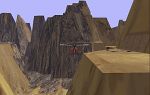
is a CFS add-on Scenery designed by Paul Harmon..4/00 This island
is a Helicopter Test Facility for practicing the fine "ART" of flying,
landing, and crashing the whirlybird. Another add-on "H_World" scenery
in the North Sea comes with many custom textures! There are quite
a few helipads in this desolated,mountainous proving ground. Fly the
canyons, land on top of mountains, or pick a tough spot to land if
your good!! lol...... Location: N56*17 E2*18 which is 22 miles west
of H_Base. Navigation: NDB 950 .... Vor 113.5. 2.1MB
Posted Jun 10, 2008 11:32 by archive
0.08Mb (230 downloads)
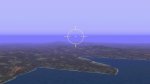
CFS
Scenery - SARDINIA Elevated mesh scenery of the Sardinia Island.
Created with CfsTmap using DEM Elevation data. Includes Airfields
with CFS menu Entry By *Cryingtoto*. 79K
Posted Jun 10, 2008 11:32 by archive
0.38Mb (207 downloads)
CFS
Scenery Add-On "Heraklion / Crete 1940" The fictional scenery
adds windmills, buildings, a moving motor-cyclist and more to the
Heraklion airfield at Martin "Wizard" Wright's beautiful scenery
"Crete" (below). By Ralf-J. Triebel (X_MAT). 388K
CFS
Scenery - Crete Demo Elevated mesh scenery of the Island
of Crete. Created with CfsTmap using DEM Elevation data. Includes
Airfields at Maleme, Retimo and Heraklion with CFS menu Entries.
Covers 18000 sq km in the Eastern Mediterranean. By Martin Wright.
27K
Posted Jun 10, 2008 11:32 by archive
0.01Mb (260 downloads)
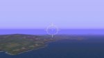
CFS
Scenery - ELBA Elevated mesh scenery of the Elba Island near
Corsica Created with CfsTmap using DEM Elevation data. Includes Airfield
with CFS menu Entry By *Cryingtoto*. 21K
Posted Jun 10, 2008 11:32 by archive
0.03Mb (242 downloads)
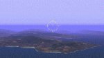
CFS
Scenery - CORSICA Elevated mesh scenery of the Corsica Island.
Created with CfsTmap using DEM Elevation data. Includes Airfields
with CFS menu Entry By *Cryintoto*. 31K
Posted Jun 10, 2008 11:32 by archive

0.05Mb (115 downloads)
Le
bonne. Ficticious. This scenery is close enough to use with
other scenery such as Texas, Malta, and Desde. Of course this Island
is big enough to host its own FFA. With 2 bases, one on the SE corner
of the island, and the NEW TBS base at the NW corner. Base 1: SE corner
located at N51*24.15 by W50*19.40 NDB setting: 408khz Base 2: TBS_base:
NW corner located at N51*37.84 by W50*40.53 Ndb setting is: 409khz.
By Allan Tucker. 55K
Posted Jun 10, 2008 11:32 by archive

0.91Mb (194 downloads)
CFS
Scenery Add-On "Attack Harburg!" The fictional scenery shows
the Harburg airfield. Harburg is a small town near Hamburg, Germany.
The scenery contains newly developed Radarstations and groups of flying
and landing parachuters. By Ralf-J. Triebel (X_MAT). 935K
Posted Jun 10, 2008 11:32 by archive
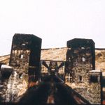
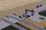
0.95Mb (227 downloads)
CFS
Scenery Add-On "The Ludendorff bridge at Remagen" At about
1 pm on March 7, the First Army reached a patch of wood above Remagen.
Second Lieutnant E.J. Burrows, commanding the lead infantry platoon,
slipped through the trees for a look at the Rhine. At the southern
edge of the town, a large railway bridge spanned the Rhine and it
was intact.. By Frederic Martenot. 1MB
Posted Jun 10, 2008 11:32 by archive
1.34Mb (264 downloads)
CFS
Scenery Add-On "Das Kyffhaeuser Projekt" This download includes
all necessary textures! The fictional scenery shows a large building
with integrated airfield. It was designed with the SS-Fuehrungsstab
B12 near Nordhausen in mind, a large complex where the germans produced
the V1 and other "Geheimwaffen" under the earth. You may move inside
the whole building and will see some of the secret planes. By Ralf-J.
Triebel (X_MAT). 1.4MB
Posted Jun 10, 2008 11:32 by archive
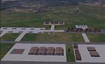
0.67Mb (167 downloads)
This
is an Island Airbase for the 27th Sentai Squadron situated
18 miles South of Texas, 37 miles South of Malta, and 53 miles Southwest
of LeBonne. You will find 2 parallel asphalt runways, one grass strip,
many hangers, airfield administration buildings, factories, Headquarters
complex, living quarters, oil and fuel storage depot, naval task force
just offshore, many anti aircraft guns to protect you, and last but
not least, the all important officers club where weary pilots can
relax and hoist a few. On the northwest shore of the island you will
find a short dirt strip with two hangers and a house for visiting
pilots. 683 KB By Joe Spencer (_27th_Jspen) Fallen Angel Design Group.
Posted Jun 10, 2008 11:32 by archive