


4.25Mb (5622 downloads)
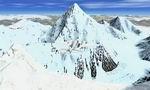
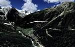
K2 is the second-highest mountain on Earth (after Mount Everest). With a peak elevation of 8,611 metres (28,251 ft), K2 is part of the Karakoram segment of the Himalayan range, and is located in the Northern Areas of Pakistan, on the border[1] between Pakistan's northern territories,[2] and the Taxkorgan Tajik Autonomous County of Xinjiang, China.[3] K2 is known as the Savage Mountain due to the difficulty of ascent and the fact that for every four people who reach the summit, one dies trying. Among the Eight-thousanders, K2 has the third highest climbing mortality rate. Karakoram is a large mountain range spanning the borders between Pakistan, China, and India, located in the regions of Gilgit, Ladakh, and Baltistan. It is one of the Greater Ranges of Asia, often considered together with the Himalaya, but not technically part of that range. By Frank Dainese
Posted Jan 29, 2009 05:51 by Frank Dainese
5.06Mb (2619 downloads)
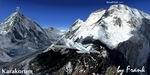
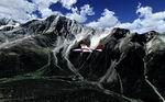
At 8,051m, Broad Peak is number 12 on the list of the fourteen 8,000m peaks, and is the third highest in the Karakoram range. It is located in Pakistan on the upper reaches of the Baltoro glacier, the main access route to the mountains which cuts through the center of the Karakoram range. Karakoram is a large mountain range spanning the borders between Pakistan, China, and India, located in the regions of Gilgit, Ladakh, and Baltistan. It is one of the Greater Ranges of Asia, often considered together with the Himalaya, but not technically part of that range. By Frank Dainese
Posted Jan 29, 2009 05:50 by Frank Dainese
3.63Mb (3986 downloads)
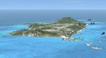
This is a scenery package for the Atlantic Oceanic Brazilian island of Fernando de Noronha. The island is now a hot destination for sea activities enthusiasts, some 200 nautical miles from the northeastern coast of Brazil.
By Jorge Amengol with just a little help from his friends.
Posted Jan 26, 2009 16:50 by Fern
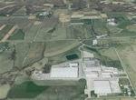
86.85Mb (977 downloads)
FSX Louisville PhotoReal Scenery Section F
This is high resolution, 1Meter/Pixel, terrain scenery for Louisville, Ky. This section, F, features farmland in Floyd and Clark County IN. This photoscenery is for DAY USE ONLY and will work for any season, but shows only the USGS aerial photo data taken in April 2002. The default FSX mesh works well with this photoscenery and no additional mesh for the area needs to be purchased. This scenery was designed to work with an earlier release of FSX 3D scenery available on this site named LouX0R and LouX1R.
By Jim Jones.
Posted Jan 25, 2009 09:32 by Jim Jones
88.66Mb (1048 downloads)
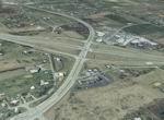
FSX Louisville PhotoReal Scenery Section K
This is high resolution, 1Meter/Pixel, terrain scenery for Louisville, Ky. This section, K, features the I64 and I265 interchange in Floyd County IN. This photoscenery is for DAY USE ONLY and will work for any season, but shows only the USGS aerial photo data taken in April 2002. The default FSX mesh works well with this photoscenery and no additional mesh for the area needs to be purchased. This scenery was designed to work with an earlier release of FSX 3D scenery available on this site named LouX0R and LouX1R.
By Jim Jones.
Posted Jan 25, 2009 09:31 by Jim Jones
448.39Mb (9681 downloads)
The Aosta Valley (Italian:Val d'Aosta) is a mountainous autonomous region in north-western Italian Alps. It is bordered by France to the west, Switzerland to the north and the region of Piedmont to the south and east.By Frank Dainese
Posted Jan 23, 2009 15:38 by Frank Dainese
373.61Mb (8785 downloads)
The Aosta Valley (Italian:Val d'Aosta) is a mountainous autonomous region in north-western Italian Alps. It is bordered by France to the west, Switzerland to the north and the region of Piedmont to the south and east.By Frank Dainese
Posted Jan 23, 2009 14:42 by Frank Dainese
7.06Mb (5988 downloads)
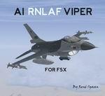
FSX AI RNLAF F-16AM And BM. AI F-16AM and BM fighters in 23 different Royal
Netherlands Air Force (RNLAF) liveries. They represent different F-16MLU
aircraft currently operated by the RNLAF. The package contains the original
AI aircraft models by Henry Tomkiewicz (with permission) so therefore no
additional aircraft downloads are necessary. It is highly recommended that
you read the included readme document for needed/suggested scenery
(generating enough military parking spaces). Also included are basic flight
plans for the F-16's flying in The Netherlands, Belgium, Germany and the
USA. The package has a self-installer for your convenience. By Rene Spaan.
Posted Jan 23, 2009 04:03 by Rene Spaan

0.44Mb (7128 downloads)
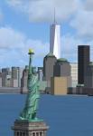
Freedom Tower, Manhattan, NYC for Flight Simulator X.
Day/Night/Specular textures.
Posted Jan 21, 2009 03:36 by Cliff Crane
0.97Mb (1758 downloads)
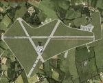
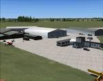
FSX scenery of Turweston
aerodrome (EGBT). Mike,
one of the instructors is
pictured by the cafe/
flight school.
By Tim Dale.
Posted Jan 21, 2009 03:33 by Tim Dale