 |
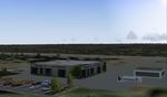
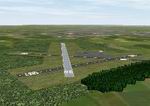
| FS2004
scenery - Pawnee, Oklahoma H97
NOT COMPATABLE WITH FS2002 In reality this is a two turf landing
strip airport - however, since I have had some family there
(maybe still do) I have taken the liberty of improving the airport
by lengthing the R32 to 5,500' ashphalt, high intensity lighting,
fuel service, improved paved parking, and ILS for the "flight
school" and for your ease of flying. NDB has also been added.
Plus: progressive taxi & tower. You will also note sailboats
and other craft in the two lakes surrounding Pawnee all of which
are autogen FS2004 addons made possible by Robert Furlan. Jimmy
R Martin. 1.1MB |
|
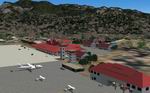 |
| FS2004
Mae Hong Son (VTCH), Thailand. Mae
Hong Son is located in Northwest Thailand near the border with
Myanmar. The terrain is mountainous, which makes approaches
into the airport quite difficult. The province has been attracting
more tourists over the last few years, which has prompted the
government has made some improvements to the airport, included
a new terminal building. Most of the buildings display traditional
Thai architecture themes. Two other small airfields are included:
Pai (VTCI) and Mae Sariang (VTCS). Martin Strong. 8.8MB |
|
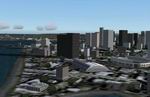 |
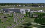
| FS2004
San Diego VFR Scenery.
Adds 134 scenery objects to the San Diego area, including the
USS Midway, Petco Park, the round hangars on North Island NAS,
ships and boats in the bay and lots more.Programmed in XML,
this scenery is very framerate friendly. By Tim Merrell. 53K |
|
 |
|
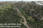
FS2004
Bella Coola Valley Terrain Mesh and Scenery Enhancements
One of the most spectacular watersheds of British Columbia's
Midcoast, the Bella Coola Valley looks pretty boring in its
default FS rendition. These files provide a LOD10 (38-m) mesh
made from CDED1 0.75-arcsec data, a new landclass file, and
accurate placements of lakes, rivers, streams, and roads.
Also includes the glaciers of the Monarch Mt. Icefield and
several forestry roads and clearcuts along the side valleys.
Made with Ground2K4 based on Landsat 7 ETM+ satellite imagery.
Holger Sandmann. 21MB
|
|
| |
| FS
2004 - Canada Airport Tower Views and Helipads PACK 1. -
This package was specially crafted to allow for a "one shot"
download process of all my latest creations and contains the
AF2_XXXX.bgl files ( with a proper control "tower view" and
1 or 2 helipads ) for 5 default airports ( without addon scenery
) for each of the ten provinces and 3 Territories of Canada
( 5 x 13 = 65 airports ). - A few airports were removed in order
to round the number of airports to 5 / prov. and territ. They
will be included in pack 2 which I will post later this year.
- Also included is a text file with the data ( longitude, latitude
and elevation ) used to create the views and to add the helipad(s).
- AFCAD utility by Lee Swordy needed (here)
to generate de AF2_XXXX.bgl files using this data. Marc Renaud.
204K |
|
| |
| FS2004
Picnic Table Fire 2004
This package contains The 2004 Picnic Table fire, about 9 NM
MW of Ft Collins, Co. Load up your Air Attack prop or Slurry
bomber and get out there. It has already creasted the ridge
and started down toward the town. Got to airport 3V5 (Ft Collins
Downtown) and fly NW hdg 290 for about 9 NM. The fire will appear
at about 5-6 NM range. Does nat have anywhere near the intensity
of a real fire of this type. By Kyle Ramsey. 6K |
|
 |
| FS2004
TFFR "Pôle Caraïbes",
International Airport of Guadeloupe Island. New Scenery of the
International Airport of Pointe-à-Pitre: " Pôle Caraïbes", located
in Guadeloupe French Caribbean Islands. By: Christian Delblond.
5.5MB |
|
 |
| FS2004
EGFH Swansea Airport, UK,
Situated 5nm WSW of Swansea Created with Airport V3. Custom
control Tower designed with FSDS.AF2 and Landclass files also
included to update the surrounding area. Author Paul Roberts
in co-operation with Mike Vernon. 265K |
|
 |
|
LOD9 (76-m)
Terrain Mesh of Namibia, southwestern Africa Add-on mesh for
the entire country of Namibia (S17-29 E11-21), including the
Caprivi Strip east to the Victoria Falls (Zambia/Zimbabwe).
The source data are 3-arcsec (~90-m) Shuttle Radar (SRTM)
files, compiled at LOD9 (76-m) resolution. Processing with
John Childs' Blackart (v3.74) and Peter Guth's MicroDEM (v7.02).
Includes a LOD7 buffer mesh to prevent blue slivers in the
mid to far distance. Consists of five parts. Holger Sandmann
5 Parts:
namib_se.zip
(24MB), namib_sw.zip
(35MB), namib_nw.zip
(35MB), namib_ne.zip
(22MB), namib_cp.zip
(16MB)
|
|
  |
|