 |
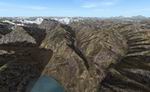
| FS2004
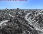
Himalayan Peaks Mesh - Namcha Barwa Highly
detailed mesh based on Shuttle Radar (SRTM) data but with many
of the void areas filled with elevation data generated from
topographic maps by Jonathan de Ferranti. The "Himalayan Peaks"
series contains LOD10 terrain mesh of prominent peaks and ridges.
There will also be a LOD9 "base mesh" series of the Himalayas.
Compiled for FS by Holger Sandmann. Fully compatible with FS2002.
15.4MB |
|
| |
| FS2004
Nevada Airports AFCAD Update.
with new taxi ways and runways. AFCAD files for : Jean ------Jean
Field OL7 Searchlight-----Searchlight Strip --1L3 Voc Tech---
Voc Teck Sand Strip ---NV26. Jose Gutierrez. 293K |
|
 |
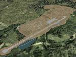
| FS2004
Mumbai (formerly known as Bombay) Scenery.
Freeware scenery using EOD, FSSC and AFCAD - Depicts Mumbai
VABB Chhatrapati Shivaji Airport. As with other sceneries I
have created, this is a fairly "light" depiction. Not too heavy
on the eye candy, nor on the frame rates. Scenery is by Matthew
Ministry and the images for most of the textures were provided
by Manu Mistry. 2MB |
|
| |
| FS2004
Mumbai Airport 32-bit textures.
These textures are to replace the default ones that come with
my Mumbai Airport scenery above. The textures included as part
of the airport package are DXT3 format (with the exception of
the lighting effects, which really need to be 32-bit, but which
compress down really well in a zip file). These textures offer
a little more subtlety - for a greater file size and perhaps
a slightly lower frame rate, depending upon your computer setup.
By Matthew Ministry and Manu Mistry. 6.5MB |
|
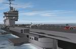 |
| FS2004
Carriers Scenery Package. 18
landable carriers across the world, Beautiful scenery. All carriers
with navaids. Textures included. By Rich Hogen. Compiled for
FS2004 by Alejandro Villa. 2MB |
|
 |
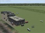
| FS2004
Khe Sanh Combat Base, Vietnam.
The site of one of the most famous battles of the Vietnam War.
Khe Sanh was originally an obscure Army Special Forces camp
perched atop a small plateau in the extreme northwestern corner
of South Vietnam near the Ho Chi Minh Trail. Later, 6,000 US
Marines of the 13th and 26th regiments, and the 37th ARVN Ranger
Batallion were deployed there. In early 1968, Khe Sanh suddenly
emerged from obscurity and became front page news all over the
world when it was besieged for 75 days by a force of approximately
40,000 North Vietnamese troops. The application of massive US
airpower, including B-52 strikes, eventually forced the enemy
to withdraw. The model represents Khe Sanh as it was in late
1967, just prior to the start of the siege. (During the siege,
virtually everything above ground, including the runway, was
destroyed by intense artillery, rocket, and mortar fire. At
that time, the base looked more like a prairie dog town or the
cratered surface of the moon.) This scenery was designed for
FS 2002 but it should work in FS 2004. George Knowles. 824K |
|
 |
| FS2004
Ipswich UK (EGSE) VFR scenery.
. A charming little grass airfield in Suffolk that was forced
to close by the local Council in 1996. This is not photoreal
scenery - it uses default objects and stock textures - but it
is close enough to the way it was. Made using SceneGenX - file
included for anyone who wants to enhance it further or change
it. Roger 'RollerBall' Mole. 138K |
|
 |
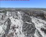
| FS2004
Himalayan Peaks LOD10 Mesh -
Pamir Highly detailed mesh based on Shuttle Radar (SRTM) data
but with many of the void areas filled with elevation data generated
from topographic maps by Jonathan de Ferranti. The "Himalayan
Peaks" series contains LOD10 terrain mesh of prominent peaks
and ridges. There will also be a LOD9 "base mesh" series of
the Himalayas. Compiled for FS by Holger Sandmann. Fully compatible
with FS2002. 49MB |
|
 |
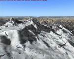
| FS2004
Himalayan Peaks LOD10 Mesh - Karakoram Highly detailed mesh
based on Shuttle Radar (SRTM) data but with many of the void
areas filled with elevation data generated from topographic
maps by Jonathan de Ferranti. The "Himalayan Peaks" series contains
LOD10 terrain mesh of prominent peaks and ridges. There will
also be a LOD9 "base mesh" series of the Himalayas. Compiled
for FS by Holger Sandmann. Fully compatible with FS2002. 39MB |
|
 |
| FS2004
Himalayan Peaks LOD10 Mesh - Kashmir
Highly detailed mesh based on Shuttle Radar (SRTM) data but
with many of the void areas filled with elevation data generated
from topographic maps by Jonathan de Ferranti. The "Himalayan
Peaks" series contains LOD10 terrain mesh of prominent peaks
and ridges. There will also be a LOD9 "base mesh" series of
the Himalayas. Compiled for FS by Holger Sandmann. Fully compatible
with FS2002. 53MB |
|
  |