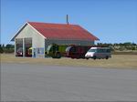
FSX
Espinho Portugal Scenery.
This is the first addon scenery I've made for FS X. The scenery
adds hangers, a fire station, a control tower, and some static
planes (among others) to Espinho, Portugal. The scenery isn't
life-like. I've created the way I wanted it. Although the scenery
is not very heavy on frames, expect a slight decrease on FPS
when flying by.By Pedro Vendeira. 2.7MB
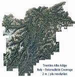
FSX
- ItalVFR - Trentino Alto Adige Photorealistic Scenery. This
scenery cover the whole of the Trentino Alto Adige with photorealistic
scenery 2 Meter resolution - Summer only - part of the ItalVFR
photorealistic scenery of Italy. By: Raimondo Taburet
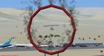
FSX
Tonopah, Nevada Airshow Scenery.
This scenery shows a fictional Air Show in Tonopah, Nevada (KTPH).
There are many aircrafts on the tarmac and a "Daredevil"
on the right side of runway 33. By Michel Revaz. 439K
FSX
Dubai Oil Rigs Scenery.
This scenery shows two fictional oilrigs offshore Dubai and
fuel tanks, a refinery, and a company HQ building onshore. Helipads
on oilrigs and on HQ building are all landable. By Michel Revaz.
645K
FSX
Aeroclub Municipal de Lincoln Scenery.
Local smalltown airfield commonly used for rural, private and
touristic flights. Based on real coordinates and visual. Has
three parking spots available for AI traffic and two runways.
First Version (1.0). Public domain. By Agustin Guirao. 146K
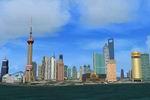
FS2004/FSX
City of Shanghai Package.
Fly over the city of Shanghai, China, as you have never done
it before! Hundreds of buildings are represented in this file
as accurate as it can be. Day and night textures. By Nestor
D'Angelo. 3.7MB
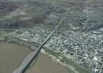
FSX
Louisville PhotoReal Scenery Section L.
This is high resolution, 1Meter/Pixel, terrain scenery for Louisville,
Ky. This section, L, features New Albany IN, Floyd Knobs, I64
and the Ohio River. This photoscenery is for DAY USE ONLY and
will work for any season, but shows only the USGS aerial photo
data taken in April 2002. The default FSX mesh works well with
this photoscenery and no additional mesh for the area needs
to be purchased. Initially 9 sections will be released surrounding
section R and will occupy 845 Mb. Additional sections may be
released based on section download counts adjacent to the intial
9 sections. By Jim Jones. 97MB
FSX
Louisville PhotoReal Scenery Section M.
This is high resolution, 1Meter/Pixel, terrain scenery for Louisville,
Ky. This section, M, features Jeffersonville, Clarksville, I65
and the Ohio River. This photoscenery is for DAY USE ONLY and
will work for any season, but shows only the USGS aerial photo
data taken in April 2002. The default FSX mesh works well with
this photoscenery and no additional mesh for the area needs
to be purchased. Initially 9 sections will be released surrounding
section R and will occupy 845 Mb. Additional sections may be
released based on section download counts adjacent to the intial
9 sections. By Jim Jones. 96MB
FSX
Louisville PhotoReal Scenery Section N.
This is high resolution, 1Meter/Pixel, terrain scenery for Louisville,
Ky. This section, N, features the Summit, Towne Center, Gene
Snyder freeway, I71 and the Ohio River. This photoscenery is
for DAY USE ONLY and will work for any season, but shows only
the USGS aerial photo data taken in April 2002. The default
FSX mesh works well with this photoscenery and no additional
mesh for the area needs to be purchased. Initially 9 sections
will be released surrounding section R and will occupy 845 Mb.
Additional sections may be released based on section download
counts adjacent to the intial 9 sections. By Jim Jones. 96MB
FSX
Louisville PhotoReal Scenery Section Q.
This is high resolution, 1Meter/Pixel, terrain scenery for Louisville,
Ky. This section, Q, features the Floyd Knobs, Gallagher Station,
West Louisville, Rubber Town and the Ohio River. This photoscenery
is for DAY USE ONLY and will work for any season, but shows
only the USGS aerial photo data taken in April 2002. The default
FSX mesh works well with this photoscenery and no additional
mesh for the area needs to be purchased. Initially 9 sections
will be released surrounding section R and will occupy 845 Mb.
Additional sections may be released based on section download
counts adjacent to the intial 9 sections. By Jim Jones. 97MB