FSX
Louisville PhotoReal Scenery Section O. This is high resolution,
1Meter/Pixel, terrain scenery for Louisville, Ky. This section,
O, features the Ford Truck Plant and Crestwood, KY. This photoscenery
is for DAY USE ONLY and will work for any season, but shows
only the USGS aerial photo data taken in April 2002. The default
FSX mesh works well with this photoscenery and no additional
mesh for the area needs to be purchased. This scenery was designed
to work with an earlier release of FSX 3D scenery available
on this site. By Jim Jones. 96MB
FSX
Louisville PhotoReal Scenery Section U. This is high resolution,
1Meter/Pixel, terrain scenery for Louisville, Ky. This section,
U, features the Cesars floating casino complex. This photoscenery
is for DAY USE ONLY and will work for any season, but shows
only the USGS aerial photo data taken in April 2002. The default
FSX mesh works well with this photoscenery and no additional
mesh for the area needs to be purchased. This scenery was designed
to work with an earlier release of FSX 3D scenery available
on this site. By Jim Jones. 90MB
FSX
Louisville PhotoReal Scenery Section T. This is high resolution,
1Meter/Pixel, terrain scenery for Louisville, Ky. This section,
T, features East Middletown, Ky and the Lakeforest community.
This photoscenery is for DAY USE ONLY and will work for any
season, but shows only the USGS aerial photo data taken in April
2002. The default FSX mesh works well with this photoscenery
and no additional mesh for the area needs to be purchased. This
scenery was designed to work with an earlier release of FSX
3D scenery available on this site. By Jim Jones. 95MB
FSX
Louisville PhotoReal Scenery Section Y. This is high resolution,
1Meter/Pixel, terrain scenery for Louisville, Ky. This section,
Y, features the South East section of the Gene Snyder Freeway.
This photoscenery is for DAY USE ONLY and will work for any
season, but shows only the USGS aerial photo data taken in April
2002. The default FSX mesh works well with this photoscenery
and no additional mesh for the area needs to be purchased. This
scenery was designed to work with an earlier release of FSX
3D scenery available on this site. By Jim Jones. 95MB
FSX
Louisville PhotoReal Scenery Section Z. This is high resolution,
1Meter/Pixel, terrain scenery for Louisville, Ky. This section,
Z, features the Mill Creek power plant in South West Louisville.
This photoscenery is for DAY USE ONLY and will work for any
season, but shows only the USGS aerial photo data taken in April
2002. The default FSX mesh works well with this photoscenery
and no additional mesh for the area needs to be purchased. This
scenery was designed to work with an earlier release of FSX
3D scenery available on this site. By Jim Jones. 90MB
FSX
OAMS – German Camp Marmal Version 1.0
The Mazar-i Sharif is the fourth largest city of Afghanistan,
with population of 300,600 people (2006 estimate). It is the
capital of Balkh province and is linked by roads to Kabul in
the south-east, Herat to the west and Uzbekistan to the north.
Mazari Sharif means "Noble Shrine," a reference to
the large, blue-tiled sanctuary and mosque in the center of
the city. A Tribune to the German soldiers in Afghanistan. Volker
Gießüb. 10MB
FS2004/FSX
Scenery--Palermo, Sicily, Italy photoreal. The airports
of Palermo Punta Raisi (ICAO code LICJ) and that of Palermo
Boccadifalco (ICAO code LICP) are found inside the scenery.
Recommended for use with ITALYM04.ZIP and ITCOAST2.ZIP. By Fulvio
Mazzokan. 48MB
FSX
Madeira Archipielago, Spain.
The archipelago of Madeira this located in the middle of Atlantic
in the 32º 38N and 16º 50 W. belongs together to 978
kilometers of Lisbon address SW. To 545 kms to the W of the
end Djouchi in Morocco and to 443 kms to the north of Tenerife
in the Canary Islands. This archipelago is part of the Macaronesia
Ensemble of islands that the Açores, The Canary islands
of Cape Verde and the own Madeira; Funchal and I Porto Santo.
By Toni Agramont. 14.4MB
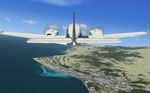
FSX
Nick's SunFix Updated).
This package will enhance the sun effects in FSX and add simulated
volumetric light rays extending from the corona. It’s
designed to work with and without light bloom and be dynamic
with the time of day, altitude, clouds and the level of atmospheric
humidity content. The elements which light bloom enhance have
been reworked so bloom is not overpowering and should display
in proper scale. Nick Needham. 1.2MB