


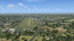
0.24Mb (1016 downloads)
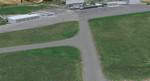
Yeovil, Henstridge & Merryfield airfields in SW UK. FSX default for these are very poor so I created them for myself. Please read the readme file within zip file. May 2014.
Posted May 27, 2014 05:55 by M.Connolly
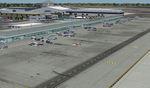
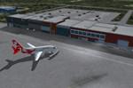
81.49Mb (1824 downloads)
Detailed scenery of Long Beach Airport (Daugherty Field), Long Beach, California, USA. This is version 4 incorporating the latest design techniques and upgraded to the latest development stage. This version includes the modern new terminal and the new parking garage. This is a brand new stand alone version for FSX/P3Dv2. By Shehryar Ansari
Posted May 26, 2014 05:38 by Nicolas Neveu
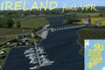
217.40Mb (1678 downloads)
IRELAND FULL VFR (for FSX Acceleration) To prevent file manipulation, and ease of installation, here "Ireland Full VFR" This pack is the sum of my addons for Ireland VFR : No. 01 to 04. Built on the Orbx scenery, but can run on a different configuration, only a few visual inconvenience. 30 locations (Castles, Abbeys, Manors, powerstations...). Created by Daniel Florentin
Posted May 26, 2014 05:25 by Nicolas Neveu
34.37Mb (879 downloads)
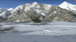
Siachen Base Camp is approximately 6 hours drive north from the town of Leh which is in the Indian State of Jammu and Kashmir. It is the Base Camp of Indian Army in the Siachen Glacier region, controlled by India but also claimed by Pakistan. The temperature goes down to -50 degrees C during winters. The Indian Army mans the Glacier operations from the Base Camp. India built the world's
highest helipad on the glacier at Point Sonam, 21,000 feet
(6,400 m) above the sea level, to supply its troops.
Posted May 25, 2014 05:45 by PollenFly
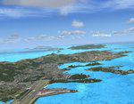
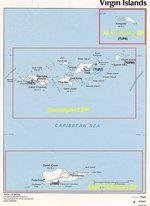
14.13Mb (2980 downloads)
British and US Virgin Islands,including the correct redefinition of coasts islands and landscape.
Includes 3 airports:
-The Cyril E. King airport at St. Thomas located on the southwestern side of St Thomas US Virgin Isl (TIST)
-Terrance B Lettsome Intl Airport Information. Located in Tortola, Virgin Isl (br) : TUPJ
-Virgin Gorda Airport located in Virgin Gorda, Virgin Islands,(br): TUPW and MESH in LOD 10 (30 m) of Virgins islands arc. By Valladier Jean Louis
Posted May 24, 2014 04:54 by Nicolas Neveu

435.87Mb (5474 downloads)
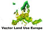
Vector land use data processed from EEA Corine Land Cover 2006 data (European Environment Agency). Data from the European Environment Agency:
- Continuous urban fabric
- Discontinuous urban fabric
- Industrial or commercial units
- Green urban areas
- Mineral extraction sites
- Non-irrigated arable land
- Permanently irrigated land
- Rice fields
- Vineyards
- Fruit trees and berry plantations
- Pastures
- Complex cultivation patterns
- Land principally occupied by agriculture, with significant areas
of natural vegetation
- Agro-forestry areas
- Broad-leaved forest
- Coniferous forest
- Mixed forest
- Natural grasslands
- Moors and heathland
- Sclerophyllous vegetation
- Transitional woodland-shrub
- Beaches, dunes, sands
- Bare rocks
- Sparsely vegetated areas
- Inland marshes
This add-on doesn't cover sea, ocean, water bodies, waterways or streams. Only dry land vectors are included. Download and install Vector Land Use Europe 2 to get the most out of this add-on. By Sami Toronen
Posted May 21, 2014 03:07 by Nicolas Neveu
356.97Mb (4410 downloads)
Vector land use data part 2, processed from EEA Corine Land Cover 2006 data (European Environment Agency). Data from the European Environment Agency: - Continuous urban fabric - Discontinuous urban fabric - Industrial or commercial units - Green urban areas - Mineral extraction sites - Non-irrigated arable land - Permanently irrigated land - Rice fields - Vineyards - Fruit trees and berry plantations - Pastures - Complex cultivation patterns - Land principally occupied by agriculture, with significant areas of natural vegetation - Agro-forestry areas - Broad-leaved forest - Coniferous forest - Mixed forest - Natural grasslands - Moors and heathland - Sclerophyllous vegetation - Transitional woodland-shrub - Beaches, dunes, sands - Bare rocks - Sparsely vegetated areas - Inland marshes This add-on doesn't cover sea, ocean, water bodies, waterways or streams. Only dry land vectors are included. Download and install Vector Land Use Europe 1 to get the most out of this add-on. By Sami Toronen
Posted May 21, 2014 02:33 by Nicolas Neveu
19.71Mb (1037 downloads)
High definition scenery of Saarbrucken in Germany. Saarbrucken is a minor international airport in Saarbrucken, the capital of the German state of Saarland. It features flights to major cities throughout Germany as well as some leisure routes. This version is for FSX and you can expect more from Europe over the next 6 months.
Posted May 21, 2014 02:32 by uploader
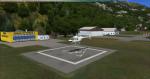
11.49Mb (785 downloads)
Realistic scenery of CYVO Val-d'Or regional airport (in western Quebec). Main buildings, many static aircrafts, vehicules and... caribous!
Posted May 19, 2014 06:50 by uploader
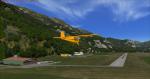
14.99Mb (1558 downloads)
The airport of Lienz-Nikolsdorf is located 9 km east from the town of Lienz, East Tyrol in Austria,
It was not in the library of FSX and it was a pity.
Now you can leave for a nice flight in the beautiful region of Tyrol.
The airport was built with custom objects and a photo-realistic base for a good approach.
Posted May 18, 2014 12:08 by Dario "Vic Dabor" Bortot