


1.37Mb (145 downloads)
FS2000
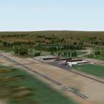
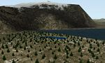
Scenery - Elma Municipal Airport, TN. Elma is 20 miles east
of Bowerman Field. The runway is 2275' long, and surrounded
by trees, keep a steady hand on the stick! All structures on
the airport are photorealistic. The ground surface is created
from the USGS doqq. By Bob Bernstein and Richard Goldstein.
1.4MB
Posted Jun 23, 2008 14:35 by archive

3.93Mb (641 downloads)
FS2000
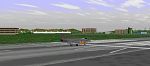
Scenery Hong Kong International Airport - Chek Lap Kok Airport
scenery enhancement for MSFS built up completely from scratch.
Highly accurate, includes new terminal building and control
tower, lighted taxiways and apron at night, static aircraft
and charts. By Thomas Kwong. 4.1MB
Posted Jun 23, 2008 14:35 by archive
1.10Mb (328 downloads)
Italy
South.
This scenery for MS Flight Simulator 2000 cover the whole Italian
territory, for great convenience he has been divided in 3 files
.zip. This scenery uses the data GTOPO30, global digital elevetion
model (DEM). The scenery of default of FS2000 foresees for Europe
reliefs altimetrici to 30 arcs for according to, correspondents
to around 1 kilometer, thanks to new techniques I have succeeded
to getting reliefs altimetric up to 3,75 arcs for according
to, using the graphic interpolation. Franco Baratti. 1.1MB
Posted Jun 23, 2008 14:35 by archive
3.22Mb (296 downloads)
Italy
Central: Scenery for Flight Simulator 2000 Mesh Terrain
Italy This Scenery is FREEWAREThis scenery for MS Flight Simulator
2000 cover the whole Italian territory, for great convenience
he has been divided in 3 files .zip. This scenery uses the data
GTOPO30, global digital elevetion model (DEM). The scenery of
default of FS2000 foresees for Europe reliefs altimetrici to
30 arcs for according to, correspondents to around 1 kilometer,
thanks to new techniques I have succeeded to getting reliefs
altimetric up to 3,75 arcs for according to, using the graphic
interpolation. Franco Baratti. 3.3MB
Posted Jun 23, 2008 14:35 by archive
4.96Mb (327 downloads)
Italian
mesh terrain scenery for Microsoft Flight Simulator 2000,
designed with Microsoft SDK and FS Terrain, GTOPO30 data have
been reworked to 3,75 arc second data using graphical interpolation
techniques Cover olso Swiss, French, Austrian Alps and Malta
1of3 file: Italy-FB-N.zip - North Italy-FB-C.zip - Center Italy-FB-S.zip
- South By Franco Baratti. 5MB
Posted Jun 23, 2008 14:35 by archive
0.04Mb (157 downloads)
South
Minas Gerais - Brazil - Lambari Scenery for MS Flight Simulator
98 --Created by Emmanuel Mauricio L. Santos Sao Paulo - Brazil
using Airport V. 2.0 With Photo realistic texture of the city.
45K
Posted Jun 23, 2008 14:35 by archive
0.57Mb (124 downloads)
Webbers
Landing! Webbers Landing is located 213 miles from Juneau
on a 298 degree heading. It has both land and water starts,
with the land runway being a gravel runway of 2400 feet. You
can also land a seaplane in the river, providing you are close
to and land parallel to the shoreline. Webbers Landing is an
observation post for the 2 channels that it oversees. There
are 2 lookout towers manned there to observe boat traffic, especially
during the winter months. The deer are plentiful, but watch
out for the bears! Stop on by and see Will. He is the permanent
Ranger on station there. Have fun!! Scenery by Don Moser / Alaska
By Don. 584K
Posted Jun 23, 2008 14:35 by archive
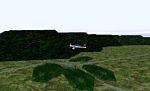
0.14Mb (189 downloads)
FS2000
Machrihanish Airfield, Scotland Situated on beautiful Mull
of Kintyre near Campbelltown. Former fully operational NATO
Base now on maintenance basis, also has small commercial terminal.Accurate
plan of airfield with taxiways, base buildings,former quarters
and terminal. Iain Gallacher. 147K
Posted Jun 23, 2008 14:35 by archive
1.16Mb (320 downloads)
FS2000
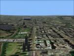
Edinburgh City Centre Version2 Scenery for Edinburgh,Scotland
includes city centre,Leith Docks and Forth shoreline.This version
has full night lighting and illumination of well known landmarks
now including Royal Yacht Britannia, Murrayfield Stadium, new
Scottish Parliament site,Dynamic Earth as well as the Castle
and Military Tattoo. By Iain Gallacher. 1.2MB
Posted Jun 23, 2008 14:35 by archive
4.18Mb (220 downloads)
FS2000
Spain & Portugal Terrain Mesh Scenery. Version 1.0 Made
from Digital Elevation Models (DEM) with Microsoft Terrain SDK.
By Ricard Alvarez. 4.3MB
Posted Jun 23, 2008 14:35 by archive