


0.28Mb (1148 downloads)
FS2004
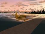
Saskatchewan Floatplane Bases .
Simple floatplane bases to remedy the lack of FS2004 floatplane
facilities in Northern Saskatchewan. These files work with both
the default scenery and Dwayne Matheson's LOD8 mesh. Lyle Froese.
288K
Posted Jun 23, 2008 14:24 by archive
0.40Mb (1369 downloads)
FS2004
An Khe Airfield and the An Khe "Golf Course" Airfield, Vietnam.
This Vietnam scenery includes two airfields: An Khe Airfield
and the An Khe "Golf Course" Airfield. An Khe was located at
the eastern end of a strategic mountain pass, about midway between
Pleiku and Qui Nhon. An Khe Airfield was a US Army facility
for fixed wing (prop) aircraft. It had a 4,300' concrete runway.
The nearby An Khe "Golf Course" Airfield was a huge helicopter
base operated by the 1st Cavalry. Its vast parking area could
accommodate several hundred helicopters. Both airfields are
a single entry in the FS airport database. The airport code
is VVAK. Runway 03/21 is the An Khe airfield and runway 17/35
is the "Golf Course" airfield. George Knowles. 407K
Posted Jun 23, 2008 14:24 by archive
0.29Mb (1325 downloads)
FS2004
Dalat / Camly Airfield, Saigon as it was in 1969.
Located in a mountainous region about 100 miles northeast of
Saigon, Dalat / Camly was the headquarters of the 362nd Signal
Company. The model is intended to replace the default Camly
airport in MS Flight Simulator. The default airport has only
a single runway, whereas Dalat / Camly airfield had two parallel
4,400' runways in 1969. Also, like most small FS airports, the
default airport has no buildings, parking ramps or other details.
George Knowles. 297K
Posted Jun 23, 2008 14:24 by archive
0.20Mb (1589 downloads)
FS2004
Vung Tau Airfield Vietnam, late 60's era.
A model of Vung Tau Airfield, a major US Army facility om the
Cape St. Jacques Peninsula about 60 km SE of Saigon. Vung Tau
is a seaside resort city. It was a popular in-country R&R center
during the Vietnam War. Surrounded by high hills, Vung Tau was
fabled for its beautiful scenery and mild climate. (Unfortunately,
the default FS 2002 terrain mesh is flat.) This scenery was
designed for FS 2002 but it should work in FS 2004. George Knowles.
206K
Posted Jun 23, 2008 14:24 by archive
0.38Mb (1035 downloads)
FS2004
Ameland & Texel,. Holland. Ameland
is a small island in the north of The Netherlands. It has one
grass.runway. Texel is a small island in the northwest of the
Netherlands. It has 2 grass runways. 392K
Posted Jun 23, 2008 14:24 by archive
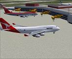
1.84Mb (14634 downloads)
FS2004
B747-400 AI Replacement Pack
Replacement for the default B747's Landmark, Soar, Pacifica,
and World Travel with Air France, British Airways, Northwest,
and Qantas. They are all flyable and will be replacement's for
the default B747 AI aircraft. By Tony Potter. 1.9MB
Posted Jun 23, 2008 14:24 by archive
0.49Mb (193 downloads)
FS2004
Lake Barkley State Park (Fictional).
A fictional airport I have created for the people that like
smaller airports. It has two runways, one made of grass and
the other concrete. I hope you enjoy it.
504K
Posted Jun 23, 2008 14:24 by archive
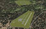
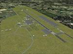
7.03Mb (1565 downloads)
FS2004
RAF Cranwell Package Pt.1.
RAF Cranwell, originally HMS Daedalus, was taken over by the
RAF in 1918 for officer training which it still does today.
See PDF for more information. I have concentrated, in part 1,
mainly around the main aircraft ramp area and buildings north
of the main hangers; this is where most of the action happens.
This download also includes an accurate AFCAD of Cranwell. By
Keith Steadman 7MB
Posted Jun 23, 2008 14:24 by archive
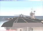
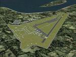
2.55Mb (4548 downloads)
FS2004
USS Carrier Martin L. King Jr.
Senator Stennis has graciously allowed his name to be removed
from ACTIVE DUTY from the USS JOHN S. STENNIS. The USS MARTIN
L. KING Jr. has just been commissioned and is ready to take
the Stennis' place. Solid DECK: 100%. No runway overhang. NO
LONG RUNWAY LIGHTS. I added the MEATBALL VASI: TCRV Approach
System at PORT AMIDSHIP. Complete CL-III ILS/NAV system. Included
is the "Carrier Zone" data for the "Cat's" and the "Trap". The
blast fences & elevators don't operate & never have. CVN74.
The Planner Airport ID is: "KING". Located 30 miles east from
it's night ops sister ship the USS NightHawk-Stennis. It is
near the west coast of "CHILI", use Chil-"i" to find by "country",
makes it easier. Flight plan capable using ILS, VFR, & GPS.
100% functional COMM's. ArresterCables.dat file for FS9 included.
Tested on XP/SP2, XP/ProSP2 > OK Steve Hinson. 2.6MB
Posted Jun 23, 2008 14:24 by archive
31.12Mb (706 downloads)
FS
2004 LRCS-Photo Real v 0.2. The town of Caransebes is situated
in South-West of Romania,
having the coordinates of 45° 25'lat N and 22° 13'long E. It
is the second largest town in the Caras-Severin County and has
a strategic geographical position,This should be a significant
improvement of LRCS Photo Real. Actually, it`s a totally rebuilded
texture set. Covers a ten time wider area then the previous
version, and fits in the default scenery textures in a wery
particular way :). Hopefully some buildings will be added soon
to encrease our delight. For a higher level of realism, it`s
advisable to be used over a 70m accuracy terrain-mesh downloadable
here: http://www.simviation.com/fsdterrainsrtm.htm
By CSIMI. 31.8MB
Posted Jun 23, 2008 14:24 by archive