


16.37Mb (2311 downloads)
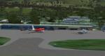
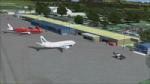
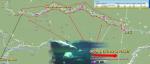
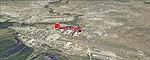
Featuring custom GMAX models, landclass changes, satelite imagery, and AFCAD airport update, Hobart International Airport (YMHB) is the result of several years development. The model itself has been designed with first hand knowledge and is highly accurate to the real airport, with photoreal textures been used. This download includes the nearby Mt. Wellington observatory and signal tower. It is recommended to be flown with FTX landclass installed. A free no restrictions demo of Tasmanian landclass is available from FTX at www.fullterrain.com/freeware.html. v2.1 makes several improvements on the previous version, with ugrades including: updated afcad; enhanced satellite imagery; several new custom models; and a significant improvment to the helicopter area behind the main terminal. Authors: Sean and Matthew Devenish.
Posted May 9, 2010 21:23 by Matthew Devenish
3.21Mb (1214 downloads)
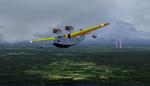
Scenery and Flights...As war clouds are stirred in Europe the Amazon river starts to see the development aviation in the vast spaces it covers over virgin jungle....Signor Natalio Canovi better known as 'Senor Bigotes' started the 'Servicio Aereo del Amazonas' 10 years ago with a Curtiss amphibian and now has the Macchi 64 twin engine amphibian as well as a Curtiss Passenger plane. Virgin scenery in a virgin jungle will receive the new pilot as he flies the thunderstorn ridden sky. Beware and be careful for the airfields as short and small and the Pirahnas await in the waters.....
Posted May 6, 2010 16:20 by Gera Godoy Canova
3.12Mb (798 downloads)
cenery and Flights...The arapaima, pirarucu, or paiche (Arapaima gigas) is a South American tropical freshwater fish. It is a living fossil and one of the largest freshwater fishes in the world. Arapaima can reach lengths of more than 2 m (6.6 ft), in some exceptional cases even more than 2.5 m (8.2 ft) and over 100 kg (220 lbs). The maximum-cited weight for the species is 200 kg (500 lbs). Dr. Amaud Fontain of the Paris Fish Foundation has prepared an expedition leaving from Iquitos in Peru and flying one of the Amazon's many affluents where this great fish have been seen. Perico del Monte, a local fisherman will fly with the Expedition to the spots where he fishes these monsters. He has assured the Dr. that there are species as large as ten feet and with a weight of over 600 kilos!!!!!. This scenery plus the added flight will engulf the pilot in an unparalleled adventure in one of the most mysterious river on earth...the Amazonas!!!( Flight prohibited to amateur pilots due to the high dangers!)
Posted May 6, 2010 15:56 by Gera Godoy Canova
0.03Mb (786 downloads)
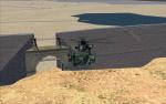
A Fictional Military Base for the FSX Squadron. Lots of Scenery, lots of runways,even a water runway has been provided. Setup for ILS Approach on Runway 18, Frequency 110.30. By Hotzoner.
Posted May 4, 2010 20:11 by HOTZONER
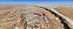
91.57Mb (1796 downloads)
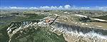
(CO) photo scenery. The Flat Tops Wilderness Area, which is the second largest wilderness area in Colorado, is named for its many flat topped mountains that are clearly visible from the sky. Trappers Lake, located in the north of the area inspired Arthur Carhart, a US Forest Service official, to initiate a plea for Wilderness preservation as early as 1919. Finally in 1975, three years before his death in 1978, the Flat Tops were designated a wilderness area. No wonder he found the area so entrancing: behind Trappers Lake loom majestic volcanic cliffs, and beyond them a vast subalpine terrain reluctantly yields to alpine tundra with an average elevation of about 10,000 feet. More than 100 lakes dot the country above and below numerous flat-topped cliffs. Steamboat Springs is an internationally known winter resort destination. By .
Posted May 2, 2010 12:33 by Gottfried Razek
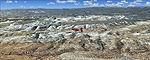
91.20Mb (1338 downloads)
. Ever
wanted to know how the scenery looks like around Kremmling VOR? Now you got the
chance! This region covers the area around Kremmling and the northern part of the
Gore Range. At Kremmling the Colorado River meets both the Blue River and the
Muddy Creek. West of Kremmling you can see Gore Canyon. This rugged and steep
canyon is almost 1000ft deep and was carved by the Colorado River on its way thru
the Gore Range. To explore the scenery depart from Mc Elroy Airfield (20V) in
Kremmling and head north. By .
Posted May 2, 2010 12:33 by Gottfried Razek
90.99Mb (1544 downloads)
photo scenery. Covers the area between the San Juan River in the north down to
Rock Point, AZ (49AZ). Most of the scenery lies on the Navajo Nation Reservation.
It completes the southeastern corner of Utah and paves our way into Colorado. By
.
Posted May 2, 2010 11:15 by Gottfried Razek
93.79Mb (1341 downloads)
(UT) photo scenery. The southern part of this region covers the Box-Death Hollow
Wilderness, with its vertical gray-orange walls of Navajo sandstone. Then comes
the Aquarius Plateau which is the highest timbered plateau in North America with
Boulder Mountain. In the north you'll find the little town of Torrey, which is
just eight miles west of Capitol Reef National Park. Extends my Grand Staircase
Escalante scenery to the north. By .
Posted May 2, 2010 11:14 by Gottfried Razek
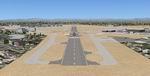
0.43Mb (2406 downloads)
Long Beach Airport (IATA: LGB, ICAO: KLGB, FAA LID: LGB), also known as Daugherty Field, is located in Long Beach, California, and serves Los Angeles and Orange Counties. The airport has four smaller runways and one long runway for jets (10,000 ft), plus nine taxiways, and occupies 1,166 acres (472 ha). It was formerly known as Long Beach Municipal Airport.The airport is under major construction. Some of the old hangers and building to the north have been knocked down. The terminal is under renovation and expansion, though not simulated here. I left all the taxiways in-tact while construction is continuing.
Posted May 1, 2010 07:52 by Uploader

0.29Mb (3006 downloads)
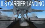
This is basically an ILS approach set up for two waypoints in the middle-east (SESRA and IBKUG) near Kuwait, Iraq, and Iran. You must use AICarriers2 to spawn a carrier at the waypoint, and then the ILS can be used to safely land the plane exactly where it it supposed to hit. This also includes refueling spots located on the rear operating lift. The updated version includes several frequencies to make navigation to the ILS easier.
Posted Apr 29, 2010 00:52 by drumaboy590