| |
|
Excel
Flight Log - Internationl Version A very simple freeware
logbook that is perfect for flight simulation. All you need
is Excel. In this version you can input hours and minutes,
the standard for log books for ICAO. By: CJ Starr. 193K
|
|
|
|
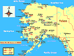
U.S.
Nav Aids now includes Alaska, New York, Northern Pennsylvania,
Northern New Jersey, Central and Western Connecticut, Central
and Western Massachusetts and Vermont. U.S. Nav Aids was
made with Paint Shop Pro. Some of the maps require you Rotate
the map 90 degrees to print the full size map. The Cities
on the map are Navigation Points, but most of them have airports
as well. All maps display VOR's, NDB's and Elevations. All
maps are the latest versions with additional Nav Aids or corrections.
Created by Bob Baker. 121K
|
|
 |
|
FLiCK
v1 - Flight Conversion Kit A small Utility I wrote
to convert airspeed, fuel consumption, distance, Bank angles,
Descent rates, just about everything. Bu Stephen Davey 158K
|
|
 |
| Kingair
Kneeboards scanned by :chris jurczyk includes: -IFR
kneeboard -VFR kneeboard **COURTESY OF KING SCHOOLS, INC. 717K |
|
| |
| UK
Landing charts in PDF format. (Acrobat) Includes EGGP/
Liverpool; EGLC/ London - City; EGLL/ London - Heathrow; EGPO/
Stornoway; EGSS/ London - Stansted;. By Bertil Gullmar TEAM
FSS. 221K |
|
 |
| Flight
Planning Form JetplanThis is a planning form I developed
to assist in flight planning for the 737 and 757 in FLY. It
can be used with all flight simulation software. This form is
public domain. This file is intended for flight simulation only,
do not use for real flight planning. Have a nice day. Jim Donlin.
40K |
|
 |
|
| |
| FSFailure,
v1.1.0 SIGNIFICANT CHANGES SINCE v1.0.0 (see README)
Tested on FS2K, should work on any simulator supported by Peter
Dowson's FSUIPC (v1.94 or higher). Fixes FS2K's pre-planned
failures by creating random system, radio, engine, and instrument
failures based on probability settings. By Jim Schein. 716K |
|
| |
| distance
calculator 1.0 This ms-dos program converts kilometers
to miles and miles to kilometers. I made it very easy to use.
Look for a program that im working on now that will convert
altitude between metric and imperial measurments. By:Mike Suitts.
13K |
|
| |
| FS2002
AI Flight Plans - UK Package Holiday Routes. Over 300
new flight plans from Newcastle, Teesside, Luton, Stansted,
Gatwick, Birmingham, Cardiff Manchester and East Midlands -
to the Greek Isles, The Canaries, The Baleirics and mainland
Spain (over a dozen destination airports). Requires TrafficTools
v1.0 (here)
or higher. By David Lawrence. 41K |
|
  |