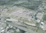
FSX
Louisville PhotoReal Scenery Section R.
This is high resolution, 1Meter/Pixel, terrain scenery for Louisville,
Ky. This section, R, features upper central Louisville, Churchill
Downs, Ky Exposition Center and the Ohio River. This photoscenery
is for DAY USE ONLY and will work for any season, but shows
only the USGS aerial photo data taken in April 2002. The default
FSX mesh works well with this photoscenery and no additional
mesh for the area needs to be purchased. Initially 9 sections
will be released surrounding section R and will occupy 845 Mb.
Additional sections may be released based on section download
counts adjacent to the intial 9 sections. . By Jim Jones. 100MB
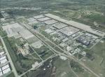
FSX
Louisville PhotoReal Scenery Section S.
This is high resolution, 1Meter/Pixel, terrain scenery for Louisville,
Ky. This section, S, features Bowman Field, St Matthews and
Oxmoor Malls, Middletown and Jeffersontown KY. This photoscenery
is for DAY USE ONLY and will work for any season, but shows
only the USGS aerial photo data taken in April 2002. The default
FSX mesh works well with this photoscenery and no additional
mesh for the area needs to be purchased. Initially 9 sections
will be released surrounding section R and will occupy 845 Mb.
Additional sections may be released based on section download
counts adjacent to the intial 9 sections. By Jim Jones. 101MB
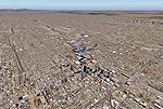
FSX
Louisville PhotoReal Scenery Section V.
This is high resolution, 1Meter/Pixel, terrain scenery for Louisville,
Ky. This section, V, features Dixie Highway, Iroquois Park and
Industry. This photoscenery is for DAY USE ONLY and will work
for any season, but shows only the USGS aerial photo data taken
in April 2002. The default FSX mesh works well with this photoscenery
and no additional mesh for the area needs to be purchased. Initially
9 sections will be released surrounding section R and will occupy
845 Mb. Additional sections may be released based on section
download counts adjacent to the intial 9 sections. By Jim Jones.
99MB
FSX
Louisville PhotoReal Scenery Scetion W.
This is high resolution, 1Meter/Pixel, terrain scenery for Louisville,
Ky. This section, W, features Louisville International Airport
and Jefferson Mall. This photoscenery is for DAY USE ONLY and
will work for any season, but shows only the USGS aerial photo
data taken in April 2002. The default FSX mesh works well with
this photoscenery and no additional mesh for the area needs
to be purchased. Initially 9 sections will be released surrounding
section R and will occupy 845 Mb. Additional sections may be
released based on section download counts adjacent to the intial
9 sections. By Jim Jones. 98MB
FSX
Louisville PhotoReal Scenery Section X.
This is high resolution, 1Meter/Pixel, terrain scenery for Louisville,
Ky. This section, X, features GE Appliance Park and Fern Creek,
KY. This photoscenery is for DAY USE ONLY and will work for
any season, but shows only the USGS aerial photo data taken
in April 2002. The default FSX mesh works well with this photoscenery
and no additional mesh for the area needs to be purchased. Initially
9 sections will be released surrounding section R and will occupy
845 Mb. Additional sections may be released based on section
download counts adjacent to the intial 9 sections. By Jim Jones.
98MB
FSX
Louisville Scenery Version LouX.0R .
Designed to work with the above Louisville Scenery areas. This
scenery includes the city of Louisville, Bowman Field and KSDF
in detail and a few objects in Indiana. Most objects from previous
Louisville versions are included and were completly redone in
GMAX with many improvements made to them. This version was specifically
designed to work with the previously issued Photoreal Terrain
scenery, LouXP01, LouXP02, LouXP03, and LouXP04 and works well
with the default mesh. These Photoreal sceneries are recommended
for a better flying experience but are not mandatory. Designed
by: Jim Jones. 19.7MB
FS2004/FSX
Phoenix-Valley Of The Sun, Arizona (AZ). This package contains
photo scenery for the greater Phoenix area covering an area
of 72x48 km. The scenery in standard FS2004 resolution of 4.7
m/pixel. By Gottfried Razek. 95.5MB
FSX
LSZH Zurich Airport, Checkered Shed Fix.
With the default FSX scenery of Zurich intl. airport, you will
maybe touch the checkered shed on RWY 34 if you land or take
off with a big airplane and crosswind. This file fix the problem.
Thanks to the makers of FSX Planner. Made by Robby Pauletto.
18K
FSX
Caribbean South Package.
Scenery of the south Caribbean islands that includes Guadeloupe,
Desirare, Les Saintes, Marie Galante, Dominique, Martinique,
St.Lucia, Barbados, St.Vincent, Bequia, Mustique, Canouan, Union
Island, Carriacou, Rondet, Grenada, Grenadines, Tobago and Trinidad.
This scenery is based on mesh terrain of Yohann Baptiste. By
Toni Agramont. 19.3MB