|
|
| |
| Boeing
767 & 777 Fuel Calculator - The Excel spreadsheet
is used to calulate optimal flightlevel , needed fuel,flight-time
and takeoff/landing weights for B767 and B777 in simulator use.
This is provided as it is with no warranty or guarantee and
no responsibility for possible damage it could cause. Can be
used, modificated and distributed without charge. It is not
to be included with any commercial product or CD-rom. Have fun
Olof Niklander . File size 18k |
|
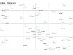 |
| FS98
Default Scenery Map. Maps show the relative positions
of airports. Maps for part or New York, Toronto, Montreal. Dallas
and Phoneix and surrounding areas. Showing airport code and
runway length. Length of just the longest runway is shown. Great
for making and planning short hops. Word 97 and also JPEG format.
By Aziz Islam. 260K |
|
| |
|
| |
| Autoland
2000 is
a simple adventure utility for FS2000/FS98 that will add autoland
ability to virtually any third party aircraft, when using the
autopilot's ILS "approach" mode feature. Autoland is being distributed
as freeware. John Cillis 4K |
|
|
|
| NAV:
A Flight Simulator scenery file viewer and flight planner.
NAV is a Microsoft Flight Simulator (versions 5, 95, 98, and
2000) compatible scenery file (BGL) viewer and flight planner.
NAV will show (and print) a map of all the navigational aids,
runways and airports in your scenery files, let you measure
distances between places, search the files for specific items,
create a flight plan showing navigational aid frequencies and
distance, fuel, and estimated time between references points,
link to Flight Simulator to show your map position updated in
real time, and control your autopilot to help you navigate.
1.7MB |
|
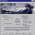 |
| FS98/FS2000
FS Meteo v4.75 will set cloud layers, wind speed, gusty
wind,rain, upper wind (ALOFT),snow,thunder,wind direction, temperature,altimeter
and visibility through an Internet connection in online mode
or in offline mode. It will check where your plane will be and
set the parameters to the real weather where you fly and will
give you up to date information during flight. FSMeteo can also
request airport weather! By Marc Philibert. 708K |
|
| |
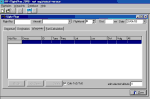
| METAR
File Getter v1.0 METAR File Getter is a small, easy
to use utility for retrieving METAR weather report files from
the internet. It was designed to give FS98 users a more realistic
experience while flying. METAR File Getter will automatically
download the METAR text files from the chosen website every
hour. Freeware written by Rich Stiver. 1.6MB |
|
 |
| IFRPlan
2000, beta version. A tool for creating flightplans
for Microsoft Flightsimulator 95, 98 or 2000, including navaid
databases, printout of flightplans and export to flight management
systems. By Juergen Becker. 7MB |
|
|
|
| Great
Circle and Rhumb Line Routes. A handy utility for FS2000
/ FS98 used to determine the Great Circle (shortest distance)
route and the Rhumb Line (constant bearing) route between any
two navaids or airports. The 6000+ entry database is quick and
easy to use requiring no manual keying. For Microsoft FS users
only. By Jeff Leezer. 181K |
|
  |