


FSX > Page 1141

207.79Mb (44236 downloads)
Flight Simulator X Service Pack 1.
Microsoft no longer hosts this update and many users will continue to need it into the future so Simviation is now hosting the file.
FSX Service Pack 1 addresses these post-release customer concerns:
Activation and installation
Third-party add-on issues
Performance enhancements
Content issues
IMPORTANT: If you have already installed the Flight Simulator X: Acceleration expansion pack, do not install Service Pack 1. NOT REQUIRED IF YOU HAVE FSX ACCELERATION OR ACCELERATION EXPANSION PACK!
Posted Sep 30, 2012 18:15 by admin
20.28Mb (1687 downloads)
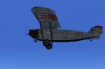
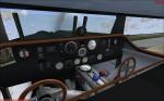
Ralf Kreibich's great Dornier Merkur now for FSX Acceleration. ALL credits are for him!! The aircrafts have full VC, I also put in a minipanel, but there's no 2d panel. 3 Different models, 5 different textures. All necessary gauges included. Enjoy!
Posted Sep 30, 2012 11:21 by erik hertzberger
0.80Mb (1282 downloads)
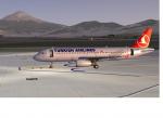
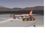
Igdir Airport, LTCT, is a new airport in the east of Turkey near the Armenian border. IGDIR Airport LTCT opened JULY 2012. This airport was made using Airport Design Editor. Main terminal added default building of ADE. This also places a few objects from the default FSX scenery library. Compiled using Airport Design Editor. Thanks to Sunay Kilic for help. Version LTCT 2012 V1.0 By Hakan DAGHAN
Posted Sep 30, 2012 10:58 by Hakan DAGHAN
20.26Mb (4403 downloads)
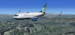
Project Opensky - B737-700 Airtran with advanced VC
for Microsoft Flight Simulator X
Skyspirit/Project Opensky native FSX Boeing 737-700 winglet model.
Upgraded to FSX using Alrot's revised Boeing 737-800 VC. This model includes Working wipers (right mouse click on switch) with rain effect. Switches for LCD Screens, EICAS, PFD, MFT. Autobrake switch. Opening pilots window. Cabin Lights switch. Realistic FMC. Ground Proximity Warning System (GPWS), More Realistic night textures.
FSX native model winglet by Skyspirit/Project Opensky.
Textures by Corey Ford.
Modified and assembled for FSX by Chris Evans.
Posted Sep 30, 2012 07:02 by chris evans
6.05Mb (2552 downloads)
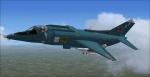
I updated Kazunori Ito's FS2004/2002 Yakovlev Yak-38 "Forger-A". I replaced the 2D panel gauges with Vladimir Zhyhulskiy's An-12Bk and An-26 gauges. No VC Panel.
Posted Sep 29, 2012 16:33 by Michael E. Roberts
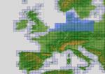
198.65Mb (3788 downloads)
"imp" means imperfect, as other mesh I have already processed is of areas that have very little vegetation cover - over the land, or has large urban areas.
This "imp" mesh will include some slight discrepancies of altitude (in the case of forested areas - by a magnitude sometimes of +15 metres-depending on how tall the trees are, in the jungle or forest canopy) over urban areas, or areas with a lot of vegetation cover - due to the limitations of the ASTER satellites infra red scanning cameras, and the software used to process the DEM data.
Areas where there is little vegetation cover, or non urban areas, the terrain should have truer values.
But I feel this ASTER DEM data is so good - why let it all go to waste - especially flying over lovely Pacific islands?
So you FSX users out there will have to take all this into account when using this mesh.
Grateful thanks to ERSDAC, and NASA for making this data freely available to the public.
ASTER GDEM
Copyright (c) 2009 - 2011 Earth Remote Sensing Data Analysis Center (ERSDAC) All rights reserved.
ASTER GDEM is a product of METI and NASA.
Posted Sep 29, 2012 07:17 by Wayne Evans

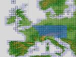
143.52Mb (4088 downloads)
"imp" means imperfect, as other mesh I have already processed is of areas that have very little vegetation cover - over the land, or has large urban areas.
This "imp" mesh will include some slight discrepancies of altitude (in the case of forested areas - by a magnitude sometimes of +15 metres-depending on how tall the trees are, in the jungle or forest canopy) over urban areas, or areas with a lot of vegetation cover - due to the limitations of the ASTER satellites infra red scanning cameras, and the software used to process the DEM data.
Areas where there is little vegetation cover, or non urban areas, the terrain should have truer values.
But I feel this ASTER DEM data is so good - why let it all go to waste - especially flying over lovely Pacific islands?
So you FSX users out there will have to take all this into account when using this mesh.
Grateful thanks to ERSDAC, and NASA for making this data freely available to the public.
ASTER GDEM
Copyright (c) 2009 - 2011 Earth Remote Sensing Data Analysis Center (ERSDAC) All rights reserved.
ASTER GDEM is a product of METI and NASA.
Posted Sep 29, 2012 06:23 by Wayne Evans
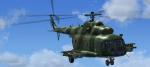
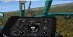
18.35Mb (8042 downloads)
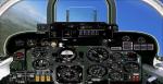
I updated Vladimir Zhyhulskiy's FS2004 Mil Mi-8MT/T replacing the incompatible gauges in the 2D and VC panels with his An-12Bk and An-26 gauges. Includes both 2d and VC panels.
Posted Sep 29, 2012 04:57 by Michael E. Roberts
214.89Mb (4266 downloads)
"imp" means imperfect, as other mesh I have already processed is of areas that have very little vegetation cover - over the land, or has large urban areas.
This "imp" mesh will include some slight discrepancies of altitude (in the case of forested areas - by a magnitude sometimes of +15 metres-depending on how tall the trees are, in the jungle or forest canopy) over urban areas, or areas with a lot of vegetation cover - due to the limitations of the ASTER satellites infra red scanning cameras, and the software used to process the DEM data.
Areas where there is little vegetation cover, or non urban areas, the terrain should have truer values.
But I feel this ASTER DEM data is so good - why let it all go to waste - especially flying over lovely Pacific islands?
So you FSX users out there will have to take all this into account when using this mesh.
Grateful thanks to ERSDAC, and NASA for making this data freely available to the public.
ASTER GDEM
Copyright (c) 2009 - 2011 Earth Remote Sensing Data Analysis Center (ERSDAC) All rights reserved.
ASTER GDEM is a product of METI and NASA.
Posted Sep 29, 2012 04:36 by Wayne Evans
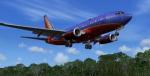
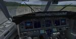
19.34Mb (14297 downloads)
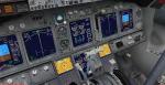
Project Opensky - B737-700 Southwest Airlines 'Canyon Blue' with advanced VC
for Microsoft Flight Simulator X
Skyspirit/Project Opensky native FSX Boeing 737-700 winglet model.
Upgraded to FSX using Alrot's revised Boeing 737-800 VC. This model includes Working wipers (right mouse click on switch) with rain effect. Switches for LCD Screens, EICAS, PFD, MFT. Autobrake switch. Opening pilots window. Cabin Lights switch. Realistic FMC. Ground Proximity Warning System (GPWS), More Realistic night textures.
FSX native model winglet by Skyspirit/Project Opensky.
Textures by unknown.
Modified and assembled for FSX by Chris Evans.
Posted Sep 29, 2012 04:27 by chris evans