


2.22Mb (1550 downloads)
FS2004/2002
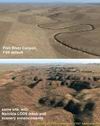
Landclass and Scenery enhancements of Namibia, southwestern
Africa
Replacement landclass file for the entire country of Namibia
(S15-30 E11-25) and parts of western Botswana. Based on the
new Global Land Cover 2000 Project data, this landclass file
is still quite basic but better (I hope) than the FS original.
In addition, I used Ground2K4 to more accurately represent natural
and man-made features in five areas throughout the country,
including Windhoek, Swakopmund/Walvis Bay, and the Fish River
Canyon. Meant to be used with my Namibia LOD9 add-on mesh series.
Landclass source files are included. Holger Sandmann. 2.3MB
Posted Jun 23, 2008 14:25 by archive
0.21Mb (8147 downloads)
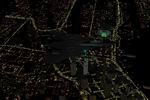
FS2004
Nighttime Brighter Highways and Roads These
are default textures to make the Highways and Roads in FS2004
look considerably more lit up with traffic at nighttime. They
make for better screenshots and make it much easier to navigate
using roads as VFR lanmdmarks at night. Please see the enclosed
screenshot for a much better look. Submitted by Jimmy Richards..
220K
Posted Jun 23, 2008 14:25 by archive
0.01Mb (384 downloads)
FS2004/2002
Shenzhen Airlines v3.0 (Summer 2004).
You need to obtain and know how to use TTools by Lee Swordy
(here) .
You install these plans at your own risk. Doug McEwen. 9K
Posted Jun 23, 2008 14:25 by archive
0.00Mb (438 downloads)
FS2004/2002
Orient Thai v3.0 (Summer 2004).
You need to obtain and know how to use TTools by Lee Swordy
(here) .
You install these plans at your own risk. Doug McEwen. 3K
Posted Jun 23, 2008 14:25 by archive
0.00Mb (578 downloads)
FS2004/2002
One-Two-Go Flightplans v3.0 (Summer 2004).
You need to obtain and know how to use TTools by Lee Swordy
(here) .
You install these plans at your own risk. Doug McEwen. 3K
Posted Jun 23, 2008 14:25 by archive
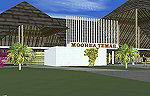
3.13Mb (2497 downloads)
FS2004,
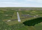
Moorea Airport, Temae, French Polynesia,
NTTM Description: This version completely redoes the previous
with a more accurate representation of the entire airport. It
contains four distinct areas including the main terminal, a
fictional sea plane pier and shelter, rudimentary hangars, and
some Polynesian huts along with a pier and sail boats in the
bay just down from the airport. This Island is the closest to
Tahiti, and you can even see the Tahiti airport from it. The
other outer Society Islands will be coming soon. It is suggested
that you also download the file Fpsimesh.zip, which has been
made for FS2004, and provides a very nice alternative to the
boring terrain which FS has put in this most beautiful area
of the world. By: Bill Melichar. 3.2MB
Posted Jun 23, 2008 14:25 by archive
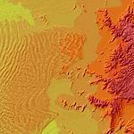
24.03Mb (823 downloads)
LOD9 (76-m)
Terrain Mesh of Namibia, southwestern Africa Add-on mesh for
the entire country of Namibia (S17-29 E11-21), including the
Caprivi Strip east to the Victoria Falls (Zambia/Zimbabwe).
The source data are 3-arcsec (~90-m) Shuttle Radar (SRTM)
files, compiled at LOD9 (76-m) resolution. Processing with
John Childs' Blackart (v3.74) and Peter Guth's MicroDEM (v7.02).
Includes a LOD7 buffer mesh to prevent blue slivers in the
mid to far distance. Consists of five parts. Holger Sandmann
5 Parts:
namib_se.zip
(24MB), namib_sw.zip
(35MB), namib_nw.zip
(35MB), namib_ne.zip
(22MB), namib_cp.zip
(16MB)
Posted Jun 23, 2008 14:25 by archive
0.26Mb (1475 downloads)
FS2004
EGFH Swansea Airport, UK,
Situated 5nm WSW of Swansea Created with Airport V3. Custom
control Tower designed with FSDS.AF2 and Landclass files also
included to update the surrounding area. Author Paul Roberts
in co-operation with Mike Vernon. 265K
Posted Jun 23, 2008 14:25 by archive
5.38Mb (2932 downloads)
FS2004
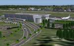
TFFR "Pôle Caraïbes",
International Airport of Guadeloupe Island. New Scenery of the
International Airport of Pointe-à-Pitre: " Pôle Caraïbes", located
in Guadeloupe French Caribbean Islands. By: Christian Delblond.
5.5MB
Posted Jun 23, 2008 14:25 by archive
0.00Mb (1009 downloads)
FS2004
Picnic Table Fire 2004
This package contains The 2004 Picnic Table fire, about 9 NM
MW of Ft Collins, Co. Load up your Air Attack prop or Slurry
bomber and get out there. It has already creasted the ridge
and started down toward the town. Got to airport 3V5 (Ft Collins
Downtown) and fly NW hdg 290 for about 9 NM. The fire will appear
at about 5-6 NM range. Does nat have anywhere near the intensity
of a real fire of this type. By Kyle Ramsey. 6K
Posted Jun 23, 2008 14:25 by archive