


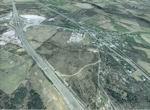
58.68Mb (954 downloads)
FSX Louisville PhotoReal Scenery
This is high resolution, 1Meter/Pixel, terrain scenery for Louisville, Ky. This section, C, features Memphis Indiana and nearby I65. This photoscenery is for DAY USE ONLY and will work for any season, but shows only the USGS aerial photo data taken in April 2002. The default FSX mesh works well with this photoscenery and no additional mesh for the area needs to be purchased. This scenery was designed to work with an earlier release of FSX 3D scenery available on this site named LouFX0R and LouFX1R.
By Jim Jones.
Posted Feb 8, 2009 07:34 by Jim Jones
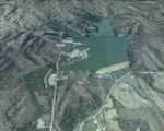
61.67Mb (850 downloads)
FSX Louisville PhotoReal Scenery
This is high resolution, 1Meter/Pixel, terrain scenery for Louisville, Ky. This section, B, features Deam Lake in Indiana. This photoscenery is for DAY USE ONLY and will work for any season, but shows only the USGS aerial photo data taken in April 2002. The default FSX mesh works well with this photoscenery and no additional mesh for the area needs to be purchased. This scenery was designed to work with an earlier release of FSX 3D scenery available on this site named LouFX0R and LouFX1R.
By Jim Jones.
Posted Feb 8, 2009 06:45 by Jim Jones
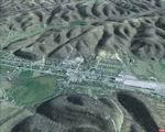
58.47Mb (956 downloads)
FSX Louisville PhotoReal Scenery
This is high resolution, 1Meter/Pixel, terrain scenery for Louisville, Ky. This section, A, features New Providence Indiana. This photoscenery is for DAY USE ONLY and will work for any season, but shows only the USGS aerial photo data taken in April 2002. The default FSX mesh works well with this photoscenery and no additional mesh for the area needs to be purchased. This scenery was designed to work with an earlier release of FSX 3D scenery available on this site named LouFX0R and LouFX1R.
By Jim Jones.
Posted Feb 8, 2009 06:42 by Jim Jones
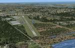
21.26Mb (1382 downloads)
Scenery of the Suwalki Flying Club aerodrome in the NE Poland. Ideal for VFR flying, gliders and ultralights. Contains vector drawn landclass, specular maps, hi-res textures, 1m/pix phototexture with seasonal variations and more... By Lukasz Kubacki (SimHangar). Happy Flying!
Posted Feb 7, 2009 13:38 by Lukasz Kubacki
4.65Mb (3833 downloads)
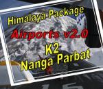
(OPSD, OPS2, OPSS, OPRT, OPMF, OPGT, OPCL, OPCH, VI57, VI65, VI66, DBO1, K2B1, K2B2, K2B3, K2B4, NPB1, NPB2, NPB3, NPB4)
This package includes 20 airports and camps (scenery & landclass) in the Karakorum area (Himalaya) around Nanga Parbat and K2. Included are short and big runways and helipads on different airports. The altitude of some airports/camps is too high for some helicopters or airplanes. Please choose the right one for your flight. Please read the readme.txt and Himalaya_Package_Readme.pdf
in this zip file included before installation.
Design by Bernhard W.
Posted Feb 1, 2009 17:55 by Bernhard W.
0.11Mb (13701 downloads)
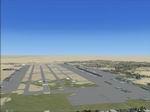
OMDB (Dubai) Scenery for FSX.
This is a AFX file for FSX. I tried it with SP1 and SP2 and it works without problems. I don't know if it will work with the Acceleration Pack.
I added the new passanger terminal as well as the complete cargo area, the flower center, the fuel tanks, a lot of maintenance hangars and other hangars, the privat terminal, a lot of fuel trucks and Helipads (all of them are default library objects).
The taxiways are 98% correct placed and signed.
The Aircrafts (AI and user) will be directed by ATC to the next parking space which is numbered as the next one.
I didn`t sign it by airline code, because I think its better by numbering them (don't worry, they are mixed numbered, and not one after the other). I also added the new parking spaces for the A380.
I know that the runway 12R/30L is not at the exactly right place, but I couldn't place it more exactly, because I don't know how to flat the tarrain in front of runway 30L, and delete the power antena (autogen scenery). By Thomas Kostka
Posted Feb 1, 2009 04:27 by Thomas Kostka
0.90Mb (1198 downloads)
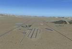
FSX Jean, Nevada (0L7) improvement.
Jean is the Primary gliding site for
the Las Vegas area (hence the lack of
lighting on 02R/20L). Tow ropes and
runway lighting do not play well together.
In addition to gliding & parchuting clubs,
the Civil Air Patrol has an L-23 Blanik
based here to service the multiple
CAP Squadrons in the Las Vegas Area.
BY Carl Kerns.
Posted Jan 31, 2009 09:34 by Carl Kerns.
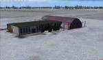
0.22Mb (1413 downloads)
Massey Ranch Airport (X50) at Edgewater, Florida.
Complete redo of the default FSX X50 airport and surrounding landclass with an actual layout of taxiways, aprons and FBO. Includes on-airport residential areas with taxiways and representations of actual hangers and other structures. By: Art Poole
Posted Jan 31, 2009 09:32 by Art Poole
0.52Mb (2870 downloads)
(Arrestor cables work - Use Rich Hogen ArrestorCables 2.6 for catapults)
Carrier, Cruisers, Destroyers 60 Miles(60 NM.) south east off the coast of Pensacola NAS.(out of site from that base)
Airport ident KNPC, NDB(ident KNPC)on deck 245.0 khz, LOC/DME(identKNPC) 108.15 mhz.(no back coarse or glide slope)
Do not spawn on Carrier location, you'll end up in the water!
Posted Jan 30, 2009 12:51 by Thunder
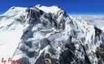
60.05Mb (4125 downloads)
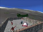
At 8,125m, it is the ninth tallest mountain in the world. Nanga Parbat is geographically a part of the Himalayas, located in relative isolation at the westernmost end of the range in Pakistan. Of the world's fourteen highest mountains, ten are Himalayan peaks: Mount Everest, Kangchenjunga, Lhotse, Makalu, Cho Oyu, Dhaulagiri, Manaslu, Nanga Parbat, Annapurna and Shisha Pangma. Only four are located in within the Karakoram Range: K2, Gasherbrum I and II, and Broad Peak. K2 is the tallest mountain in the Karakoram Range and her three 8000m neighbors lie within 20 km. Nanga Parbat is 200 km away. Karakoram is a large mountain range spanning the borders between Pakistan, China, and India, located in the regions of Gilgit, Ladakh, and Baltistan. It is one of the Greater Ranges of Asia, often considered together with the Himalaya, but not technically part of that range. By Frank Dainese
Posted Jan 29, 2009 06:21 by Frank Dainese