


FSX > Page 1196
29.08Mb (2802 downloads)
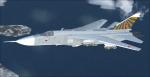
I updated SERGEY IVANOV and RAY PARKER's FS2004 AI SU-24M Package to be flyable in FSX. I added Kazunori Ito's Sukhoi Su-24 2D Panel re-gauged per the panel bitmap and real world photos and videos of the Su-24 using gauges from Jan Moravec's Su-15 2D panel, HJG's L1011 and Vladimir Zhyhulskiy. I also added Aaron R. Swindle,s Skysong Soundworks Soviet Mig-21 Fighter Soundpackage. There are a total of 31 aircraft with 5 load outs: Clean, 3 KAB 1500 bombs, 32 OFAB 250 bombes, 2 PTB external tanks or 4 X-23 (Kh-23 Grom/AS-7 Kerry) missiles. I also gave it a ground/terrain radar and included the origional Traffic BGL. 2D panel only, no VC.
Posted Nov 3, 2012 19:14 by Michael E. Roberts
0.11Mb (3977 downloads)
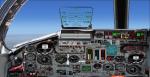
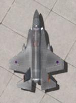
This package contains 2 sets of camera views ( defined by camera definitions in the aircraft.cfg file ) for
the beautiful Iris Simulations ex-payware Lockheed Martin F-35 Lightning II JSF. There are 2 packages
available on Simviation but it is the same aircraft.
I also use the "F-35 JSF Afterburner Mod" package by Robert Wahrenbrock.
Version 1.1 is an upgrade of version 1.0. Cameras are located at about the same level of the aircraft.
Version 2.0 is based on version 1.1 but some of the cameras are placed at a higher level.
10 cameras pointing at the aircraft - including a new "Top-down" zoomable view.
Total of 6 VC cams including 2 new "Over the shoulder" views.
See Read me.txt file for very easy installation procedures.
Camera definitions sets are included in 2 separate text files.
Available.pdf and Top 20.pdf for informations about my "camera definitions" packages.
Required files:
required file
Posted Nov 2, 2012 23:00 by Marc Renaud
1.04Mb (1192 downloads)
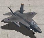
FSX Menu thumbnails for the FS2004 Nachang k8 Karakorum by gmaxac.
The wonderfull Nachang k8 Karakorum by gmaxac was made for FS2004 and therefor the package has no UI thumbnails in FSX.
Since it works fine in FSX I decided to waste a couple of hours creating UI thumbnails for people who installed this nice airplane in FSX.
Many thanks to Pierre Marchadier and Jonathan Hilaire "Rooster"/GMax Academy for this great bird.
Required files:
required file
Posted Nov 2, 2012 22:25 by Raoul de Miranda
4.08Mb (1970 downloads)
FSX/FS2004 - Small fix for my SO-8000 Narval package.
Following several comments or requests on the internet, this will fix more realistically the contra-rotating movement of the propellers and give them a more transparent texture.
Just unzip the file an copy/paste the 3 model folders and the texture folder in your SO_8000_Narval root folder in order to replace the old ones by these ones. If asked to overwrite, answer yes.
Needs the original SO-8000 Narval package.
Required files:
required file
Posted Nov 2, 2012 19:55 by Patrice Grange
33.13Mb (3428 downloads)
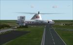
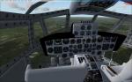
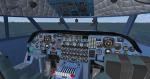
Kazito's great VSTOL Fairey Rotodyne, now flyable in FSX. All credits go to him AND to Rob Barendrecht for reworking his VSTOL-gauge. Thanks to him this rotorcraft is now fully VSTOL in FSX-Acceleration. I put in 3 different panels with all the necessary gauges, so there should at least be one you'll like :-).NO working VC, though it looks like one (gauges don't work). 4 Different liveries. I suggest you read the readme's carefully. Enjoy!
Posted Nov 2, 2012 18:21 by erik hertzberger
0.05Mb (2641 downloads)
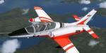
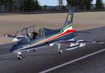
MB339PAN_FSX_updated files.txt (30 October 2012)
The files enclosed in this archive ( aircraft.cfg ,MB339_Pan.air and panel.cfg) solves some problems with the model flight behaviour and with Autopilot not working in the right way in the original model.
Modificatios by Giovanni Quai to Massimo Taccoli model.
Required files:
required file
Posted Nov 2, 2012 10:54 by Massimo Taccoli
6.59Mb (6590 downloads)
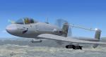
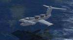
LUN Ekranoplan (Soviet Navy colors). The Lun-class Ekranoplan was designed in the late 1980s for the Soviet Union Forces. It uses a wing-in-ground-effect concept to skim low over the water at high speeds. The Lun, Russian for 'Dove', is also one of the largest aircraft ever built, rivalling the size of the Spruce Goose. This aircraft is fitted with six fixed-elevation SS-N-22 Sunburn anti-ship missile launchers. It was also known colloquially as the 'Caspian Sea Monster'. Full VC. Read docs how to fly! Ex payware from Alphasim/Virtavia
Posted Nov 2, 2012 08:35 by alphasim
0.23Mb (1802 downloads)
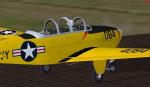
FSX/FS2004 T-34 Mentor fix.
This is a fix for the wheels and turning prop problem with the Beech T-34 Mentor in FSX Acceleration. Fix by A.F.Scrub
Required files:
required file
Posted Nov 2, 2012 06:43 by A.F.Scrub
0.72Mb (2910 downloads)
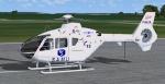
Textures for the freeware EC 135 by Heiko Richter updated by Danny Garnier. This repaint is the EC 135 of SAMU Air Rescue 94 based at the Hospital of Creteil, Paris.
Required files:
required file
Posted Nov 2, 2012 05:58 by Greenhopper
48.12Mb (4340 downloads)
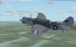
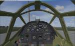
Curtiss SB2C-4 Helldiver, updated for FSX-Acceleration. All credits go to Wolfgang "Wolfi" Faber (see the original readme!). 2 Models, 5 liveries. Working VC, all necessary gauges included. Wings fold, divebrakes work together with the bombbay-doors, tailhook comes out, cowlflaps work and rear cockpit closes. Gun-effects for fun. Enjoy!
Posted Nov 1, 2012 19:29 by erik hertzberger