


.png.jpg-thumb.jpg)
0.23Mb (520 downloads)
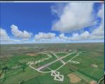
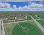
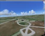
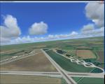
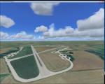
Seattle-Tacoma International Airport, KSEA updated scenery. FAA airport diagram can be used for navigation.
Note: RWY34L/16R ILS approach only. otherwise use visual.
Posted Apr 19, 2016 14:35 by Austin Dunbar
149.13Mb (1071 downloads)
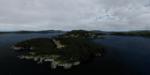
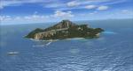
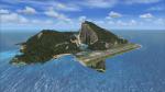
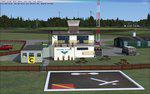
Located just a minute flight from FTX/ORBX's 74S Anacortes airport, (and actually covered in their scenery) Allan Island is a small 292-acre private island which received its name during the 1841 Wilkes expedition in honor of Lt. William Henry Allen, who was killed while commanding the USS Argus during the War of 1812. Allan Island is part of the San Juan Island Chain. Allan Island features an array of new objects and techniques which we have never used before in our development. This island is coated in a beautiful set of 30cm/px photoreal textures which will make you feel right at home in the PNW. For the first time ever, we have fully deployed an extremely high resolution digital elevation model, covering Allan and neighboring Burrows and Young Island in 2m/px resolution. An outstanding achievement.
Following these two combinations, Allan Island is also host for a brand new set of object libraries that arrived in the latest Emerald Object Library v2.0 build. The highlights of these models being the brand new 55 gallon fuel drums and slick traffic cones. Allan Island features a new take on our previous ground vegetation outtakes. We have deployed a new feature covering the entire runway it shorter 3D grass. This feature has turned out extremely nice so far, but may be a performance hog on slower systems. (Midrange is open for debate) Allan Island also features a nifty control panel in which you can easily deactivate features in the scenery, as well as swap the summer 3D grass for icy winter style grass.
Developed by Chris Britton of Emerald Scenery Design.
Posted Apr 18, 2016 18:41 by Emerald Scenery Design
0.01Mb (1401 downloads)
My version of the Tenzing-Hillary Airport (VNLK) in Lukla. One of the most dangerous airports in the world.
Posted Apr 18, 2016 17:35 by Geoff Peel
0.03Mb (1613 downloads)
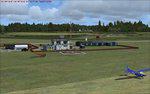
Some years ago I posted this scenery which I must apologise had many mistakes.
I have learnt a lot since then and all the mistakes have now been corrected in this pack.
The new scenery still has the upgraded Jauncho Yrausquin airport (SABA) which can accomodate heavies (no more surf on the runway) and my fictitious airport Shamrock Ridge (COLL) on the same island above SABA with a sheer 880ft cliff facing you on landing and a take-off between two cliff faces.
Lots of new scenery has been added... beaches, waterfalls, helipads and seaplane docks with starts and a cruise liner anchored just off a new small sheltered harbour below Shamrock Ridge's runway 4.
Special thanks go to my FSX friend Miles Franklin in Caracas, Venezuela for encouraging me to do the update,also for helping me find all the mistakes and for all his ideas for additional scenery inspiring me to do the fix. Created by Geoff Peel using ScruffyDuck Software Airport Design Editor FSX Edition.
Hope you enjoy !
Posted Apr 18, 2016 17:14 by Geoff Peel
2.25Mb (451 downloads)
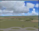
RAF Blakehill Farm (ICAO X1BK) was an RAF airfield situated in Wiltshire, England. The station was originally allocated to the United States Army Air Forces Ninth Air Force but not used.
It opened in 1944 and was home for transport aircraft of No. 46 Group Transport Command. In 1948 the airfield was a satellite of RAF South Cerney and used by training aircraft before the airfield closed in 1952 and was returned to agricultural use.
After WWII, GCHQ set up an "experimental radio station", a top secret research facility, on the site of the RAF's wartime airfield at Blakehill Farm. It consisted of huge communications masts arranged in mysterious strategic patterns in the middle of the old airfield. The site was still active in some capacity until the mid 1990s and traces of the former antenna bases can still be seen on satellite photographs.
The site is now a Wiltshire Wildlife Trust nature reserve.
Posted Apr 17, 2016 14:38 by Terry Boissel
0.93Mb (363 downloads)
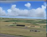
RAF Broadwell (ICAO X2BW) is a former Royal Air Force station located 2 miles north of Broadwell and 3 miles southeast of Burford, Oxfordshire, within 2 miles of RAF Brize Norton.
It opened on 15 November 1943 and closed on 31 March 1947, operating under RAF Transport Command. It consisted of 3 concrete runways in triangular configuration.
Broadwell took part in the D-Day assaults with nearby RAF Down Ampney and RAF Blakehill Farm. Broadwell had two such squadrons, No. 512 Squadron RAF and No. 575 Squadron RAF were based here, flying the Douglas Dakota.
In February 1944, No. 512 Squadron was transferred to No. 46 Group at RAF Broadwell, it was a tactical Dakota squadron and started training glider towing and parachute dropping. Its first operation in the new role was a leaflet drop on 5 June 1944 over France, this followed intensive flying in and out of France including dropping parachutists at Arnhem.
On the eve of D-Day No. 575 Squadron dropped 5 Para into the invasion drop zone. On 6 June, it towed 21 Horsa gliders into France. In the next few weeks it started a casualty evacuation service from France back to England. In September 1944, it was involved in operation market garden to Arnhem where it suffered severe casualties.
The airfield continued to be a terminus for long-range transport operations to Europe, the Middle East and India.
Source: Wikipedia
Posted Apr 16, 2016 13:36 by Terry Boissel
8.84Mb (591 downloads)
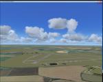
FSX-Sleap, near Shrewsbury, is the home of Shropshire Aero Club,and once a satellite of nearby RAF Shawbury and it was used for training ATC personel.
Posted Apr 16, 2016 05:44 by Alf Denham
1.94Mb (417 downloads)
RAF Down Ampney (ICAO X2DA) was a Royal Air Force station located 1.8 miles (2.9 km) north east of Cricklade, Wiltshire and 3 miles (4.8 km) south west of RAF Fairford, Gloucestershire.
The airfield operated during World War II from February 1944 until February 1947.
Down Ampney was part of a group of 3 airfields with RAF Broadwell and RAF Blakehill Farm dedicated to air transportation.
No. 48 Squadron RAF and No. 271 Squadron RAF flew Douglas Dakotas on major missions. On D-Day they dropped the main elements of the 3rd Parachute Brigade in Normandy as well as towing Airspeed Horsa gliders across the English Channel.
They were also active in Operation Market Garden (Arnhem) and the Rhine crossing.
Source: Wikipedia
Posted Apr 15, 2016 09:52 by Terry Boissel
1.51Mb (285 downloads)
RAF Fairford (IATA: FFD, ICAO: EGVA) is a Royal Air Force (RAF) station in Gloucestershire, England which is currently a standby airfield and therefore not in everyday use.
RAF Fairford was constructed in 1944 to serve as an airfield for British and American troop carriers and gliders for the D-Day invasion of Normandy and Operation Market Garden during World War II
Posted Apr 14, 2016 03:10 by Terry Boissel
0.80Mb (232 downloads)
RAF Ramsbury is a former Royal Air Force station located 5 miles (8.0 km) east-northeast of Marlborough, Wiltshire, England. Opened in 1942, it was used by both the Royal Air Force and United States Army Air Forces. During the war it was used primarily as a transport airfield.
With the end of military control Ramsbury was returned agricultural use. By the mid-1960s, much of the concrete had been removed.
Posted Apr 11, 2016 03:58 by Terry Boissel