


23.80Mb (967 downloads)
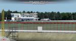
Polish Airports Vol. 2 X v4 DEMO is a package of detailed sceneries of EPSC Szczecin, EPLL Lodz, EPZG Zielona Gora and EPRA Radom airports in Poland, fully compatible with FSX/FSX:SE/P3Dv1/P3Dv2/P3Dv3/P3Dv4 and FSW by Dovetail. This product is a fully functional DEMO version of the commercial payware product. It features same airports layout as in the full version but with limited 3D objects and low resolution textures. Using this free demo ensures no problems with online (VATSIM, IVAO, multiplayer etc.) flying in case some users use the payware scenery and some don't. Szczecin-Goleniow "Solidarnosc" (SZZ/EPSC) is the main domestic and international airport serving the city of Szczecin in Poland. Lodz Wladyslaw Reymont (LCJ/EPLL), formerly known as Lodz-Lublinek Airport, is a regional airport in central Poland. Zielona Gora-Babimost (IEG/EPZG) is a regional post-military airport located within the greater Zielona Gora agglomeration. Radom Airport (RDO/EPRA), also known as Radom-Sadków Airport is a civil and military airport in central Poland The product is equipped with an automatic installer, which means that the scenery will be automatically added to the Flight Simulator Scenery Library. Please uninstall all previous versions of this airport you may have installed before. Please make also sure that no duplicated AFCAD files are installed. Enjoy your virtual flying with Drzewiecki Desig
Posted Aug 22, 2017 10:24 by Drzewiecki Design
36.58Mb (1772 downloads)
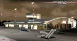
Polish Airports VOL.1 X v4 DEMO is the 4th version of detailed sceneries of EPGD Gdansk, EPKT Katowice, EPRZ Rzeszow (+EPRJ) and EPLB Lublin (+EPSW) airports in Poland, fully compatible with FSX/FSX:SE/P3Dv1/P3Dv2/P3Dv3/P3Dv4 and FSW by Dovetail.
Gdansk Lech Walesa Airport (GDN/EPGD) is an INT airport, the 3rd largest airport in Poland, often used as a diversionary airport for Warsaw Frederic Chopin Airport in the event of poor weather or emergencies.
Katowice International Airport (KTW/EPKT) is an INT airport, which service both passenger flow and cargo flights. Its concrete runway is 3,200 m and can accommodate even heavy transports such as An-124 or An-225.
Rzeszow-Jasionka Airport (RZE/EPRZ) is an INT airport located in southeastern Poland. Near to EPRZ there is located a smaller Rzeszow Jasionka Airport (EPRJ) used by Rzeszow Aeroclub (900x30m lightened asphalt runway, 700x100m grass strip).
Lublin Airport (Port Lotniczy Lublin) (LUZ/EPLB) has a 2520m runway, and the terminal facilities are capable of handling 4 x B738/A320.
This Demo version of the commercial product features same airport layout as in the full version but with limited 3D objects and low resolution textures. Using this free demo ensures no problems with online (VATSIM, IVAO, multiplayer etc.) flying in case some users use the payware scenery and some don't.
The product is equipped with an automatic installer, which means that the scenery will be automatically added to the Flight Simulator Scenery Library. Please uninstall all versions of included airports you may have installed before, prior to installing this product. Please also make also sure that no duplicated AFCAD files are installed. Previous version had 1114 d/l's.
Enjoy your virtual flying with Drzewiecki Design!
Posted Aug 22, 2017 10:22 by Drzewiecki Design
18.56Mb (1820 downloads)
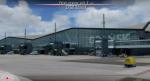
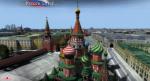
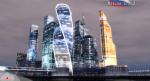
Moscow City X Demo is a very detailed model of Moscow metropolitan area in Russia, together with lite sceneries of 7 airports (UUWW Vnukovo, UUDD Domodedovo, UUBW Zhukovski, UUMO Ostafyevo, UUBM Myachkovo and UUMB Kubinka), many heliports and thousands of buildings. This product is fully compatible with FSX/FSX:SE/P3Dv1/P3Dv2/P3Dv3/P3Dv4 and FSW by Dovetail.
It's a fully functional DEMO version of the commercial payware product, copmatible with both UUEE Moscow Sheremetyevo X by Drzewiecki Design and UUDD Moscow Domodedovo FSX/P3D by MDesign. It features same airport layout as in the full version but with limited 3D objects and low resolution textures. Using this free demo ensures no problems with online (VATSIM, IVAO, multiplayer etc.) flying in case some users use the payware scenery and some don't.
Moscow is the capital city and the most populous federal subject of Russia. It's the second most populous city in Europe after Istanbul and the 8th largest city proper in the world, as well as the largest amongst high income economies.
It's equipped with an automatic installer, which means that the scenery will be automatically added to the Flight Simulator Scenery Library.
Please uninstall all previous versions of the airports included in this package that you may have installed before. Please make also sure that no duplicated AFCAD files are installed!
Enjoy your virtual flying with Drzewiecki Design!
Posted Aug 22, 2017 08:14 by Drzewiecki Design
15.39Mb (2347 downloads)
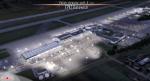
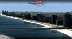
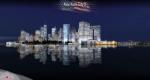
Miami City X DEMO features an extremely detailed scenery of Miami City in Florida, United States, fully compatible with FSX/FSX:SE/P3Dv1/P3Dv2/P3Dv3/P3Dv4 and FSW by Dovetail.
This Demo version of the commercial product is a fully functional freeware scenery, perfectly aligned with the full payware version. This ensures no problems with online (VATSIM, IVAO and multiplayer) flying in case some users have the payware scenery and some don't. The demo gives a few downtown buildings and AFCAD files for KMIA, KTMB and KOPF airports.
Miami is a city located on the Atlantic coast in southeastern Florida and the county seat of Miami-Dade County. This product gives you the possibility to fly over a very large area of Miami City, with ground, autogen, hundrieds of custom-made photoreal buildings, including lite sceneries of KMIA, KTMB and KOPF airports.
It's equipped with an automatic installer, which means that the scenery will be automatically added to the Flight Simulator Scenery Library.
Please uninstall all previous versions of this airport you may have installed before. Please make also sure that no duplicated AFCAD files are installed. Previous version had 1313 d/l's.
Enjoy your virtual flying with Drzewiecki Design!
Posted Aug 22, 2017 06:48 by Drzewiecki Design
23.42Mb (1504 downloads)
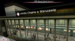
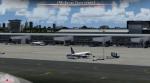
EPWA Warsar Chopin Airport X DEMO features an extremely detailed scenery of EPWA Chopin airport in Warsaw, Poland, fully compatible with FSX/FSX:SE/P3Dv1/P3Dv2/P3Dv3/P3Dv4 and FSW by Dovetail.
This product is a fully functional DEMO version of the commercial payware product. It features same airport layout as in the full version but with limited 3D objects and low resolution textures. Using this free demo ensures no problems with online (VATSIM, IVAO, multiplayer etc.) flying in case some users use the payware scenery and some don't.
Warsaw Chopin Airport (WAW / EPWA) is is an international airport located in Warsaw, Poland's capital, which handles just under 40% of the country's air passenger traffic. There are two crossing runways (2800m and 3690m), a number of hangars, a cargo terminal and a passenger terminal, completely rebuilt in 2008-2015.
The product is equipped with an automatic installer, which means that the scenery will be automatically added to the Flight Simulator Scenery Library. Please uninstall all previous versions of this airport you may have installed before. Please make also sure that no duplicated AFCAD files are installed. Previous version had 1883 d/l's.
Enjoy your virtual flying with Drzewiecki Design!
Posted Aug 22, 2017 06:25 by Drzewiecki Design
25.81Mb (3245 downloads)
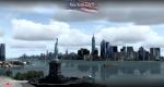
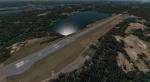
New York City X DEMO features a detailed scenery of New York city in the United States of America, fully compatible with FSX, FSX STEAM, P3D v1/v2/v3/v4 and FSW by Dovetail.
A demo version of New York City X is provided. This is a fully functional freeware scenery, perfectly aligned with the full payware version. This ensures no problems with online (VATSIM, IVAO and multiplayer) flying in case some users have the payware scenery and some don't. The demo gives you the most important (largest) downtown buildings with a low quality photoreal ground for Manhattan area, as well as low quality heliports.
This scenery add-on features 2500 sq km of terrain with autogen and over 6100 photoreal New York buildings in the city, which is the most populous in the United States and the center of the New York Metropolitan Area, one of the most populous urban agglomerations in the world.
The product is equipped with an automatic installer, which means that the scenery will be automatically added to the Flight Simulator Scenery Library.
Please uninstall all previous versions of similar sceneries you may have installed before. Please make also sure that no duplicated AFCAD files are installed.
Enjoy your virtual flying with Drzewiecki Design!
Posted Aug 10, 2017 04:59 by Drzewiecki Design
-2.jpg-thumb.jpg)
-2.jpg-thumb.jpg)
39.38Mb (2318 downloads)
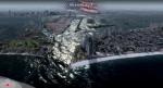
Washington X DEMO features an extremely detailed scenery of large area of Washington, Dstrict of Columbia, United States, fully compatible with FSX, FSX STEAM, P3D v1/v2/v3/v4 and FSW by Dovetail.
With this product you are free to fly to any of 5 airports (KDCA, KCGS, KADW, KVKX, W32) and many heliports in the area, admire some of the world-renowned landmarks like Capitol or Pentagon, or simply pay a visit to The President of the United States.
This Demo version of the commercial product is a fully functional freeware scenery, featuring same airport layout as in the full version but with limited 3D objects and low resolution textures. This ensures no problems with online (VATSIM, IVAO and multiplayer) flying in case some users have the payware scenery and some don't.
It's equipped with an automatic installer, which means that the scenery will be automatically added to the Flight Simulator Scenery Library.
Please uninstall all previous versions of the above-mentioned airports you may have installed before. Please make also sure that no duplicated AFCAD files are installed.
Enjoy your virtual flying with Drzewiecki Design! Previous version had 1380 d/l's
Posted Aug 10, 2017 04:40 by Drzewiecki Design
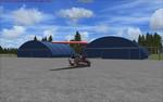
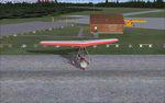
42.87Mb (372 downloads)
This is a full redux of the real life Tobermory Airport (CNR4) in Ontario, Canada. The runway, hangars, fuel shed (except the pump itself), FBO, Sign, gate, Windsock, parking lot, perimeter benches, warehouse accross the street and light were created in GMAX by me and imported and placed using Model Converter X. I did my best to place, scale and model these items as accurately as possible. I also added a few new textures. By Chris Black
Posted Aug 9, 2017 03:32 by uploader
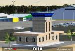
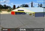
6.65Mb (533 downloads)
FSX/P3D Azadi Airport OIIA - Qazvin
The very first General Aviation airport in Iran.
by Amirhossein Daryaei
Posted Jul 7, 2017 21:39 by Amirhossein Daryaei
37.64Mb (884 downloads)
Kuusamo airport (EFKS) scenery in Finland. Light enhancement of EFKS with 15cm/pix photoscenery, correct parking and markings, correct terminal and buildings and custom autogen. You have to experience the beauty of Lapland in this approach! Compatible with FSX, Prepar3D v3 and Prepar3D v4!!!
Posted Jul 6, 2017 04:03 by Joona Toivola