


FS2002 > Page 338
1.58Mb (342 downloads)
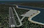
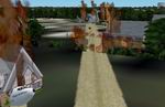
Northwoods
SAR Center is
located approximately 30 miles SE of Ketchikan Intl (PAKT) in
SE Alaska. Northwoods is the Operations Base for the Virtual
Search and Rescue VA, providing SAR ops to SE Alaska and Western
BC. Includes 5500 ft. runway, hospital facilities, hangers and
more. AFCAD files included, working ATC and shows on GPS and
Map View. By Joe Spencer - CSR_Rescue_1. 1.6MB
Posted Jun 23, 2008 14:31 by archive
2.28Mb (449 downloads)
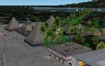
FS2002
Huahine Airport and sea plane base, Huahine, French Polynesia,
Fare.....NTTH Description: This scenery redoes the main terminal
and hangar area, and adds a base for sea planes at the Huahine
airport. This is one of the major airports of French Polynesia,
and is situated on a beautiful island with lagoons all around
it. Like Bora Bora, and Moorea, it is a major tourist destination
with crystal clear turquoise waters, and luxury resort hotels.
It is in the Society Island group, and is a short hop from Tahiti
or the other paradise islands surrounding it. .By: Bill Melichar.
2.3MB
Posted Jun 23, 2008 14:31 by archive
0.10Mb (208 downloads)
Tahiti
Afcad files and flight plans
Here is three afcad files for the following scenery Tahiti internation,
Bora bora and Moorea made by Bill Melichar use them with Lee
Swordy's AFCAD program. Also I have made up some flight
plans that can be used with Traffic Tools also by same highly
intelligent guy Thanks Lee. 100K
Posted Jun 23, 2008 14:31 by archive
1.43Mb (651 downloads)
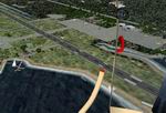
FS2002
Helicopter Scenery - Number 2 in New Orleans Series by
Charlie Young. This installment contains a heliport downtown
near the Superdome, the Jackson Barracks military establishment,
a ship fire in the Mississippi River and Fire equipment plant
in Holden, La. 1.4MB
see update
below
Posted Jun 23, 2008 14:31 by archive
0.24Mb (500 downloads)
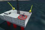
Fictional
Oilrigs at Baia de guanabara on Rio de Janeiro Brasil! The
NDB is 234.00 and the location is S22* 53.22 W04309.83 There
is 6 Oilrigs in all coast area at Rio de Janeiro PLease Enjoy!
By Gustavo Baumgarten. 248K
Posted Jun 23, 2008 14:31 by archive
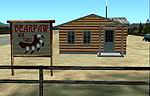
2.24Mb (265 downloads)
FS2002
Scenery - Bearpaw Air Taxi. A fictional airport located
3 miles east of Iliamna, Alaska. This is a private airfield
with a 2000ft gravel runway and floatlpane dock, it is intended
to be used as a base of operations for flights to and from other
bush scenery I have made in the Iliamna area. Sound files for
Lago's FSSoundScape are also included. by Tom Fica. 2.3MB
Posted Jun 23, 2008 14:31 by archive
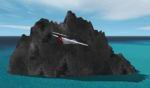
0.16Mb (226 downloads)
Balls
Pyramid Version 1 (GMAX)
Located 15NM South East of Lord Howe Island (YLHI), rises 551m
from the sea floor. Version 1 does not include wave effects
unfortunately. Mike "Tshikwara" Hill. 166K
Posted Jun 23, 2008 14:31 by archive
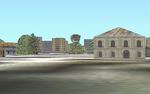
0.76Mb (670 downloads)
Autogen
Buildings (4) Asia & the Pacific FS2002 Scenery. The fourth
set in the series of replacement texture sheets intended to
improve the appearance of the default Autogen buildings. This
one covers Asia and much of the Pacific. (See also AGBldAfr.zip,
AGBldEur.zip, AGBldLat.zip). Freeware by Gerrish Gray. 775K
Posted Jun 23, 2008 14:31 by archive

1.88Mb (403 downloads)
FS2002
Moorea Airport, Temae, Island of Moorea, French Polynesia...
This scenery redoes the main terminal at Moorea airport, and
adds a sea plane base in the lake near the end of the runway,
plus a luxury resort hotel on the bay behind the airport. The
scenery includes parking areas, roadways, boat and seaplane
docks, sail boats out in the bay, indigenous landscaping, and
nice night lighting effects....NTTM By: Bill Melichar. 1.9MB
Posted Jun 23, 2008 14:31 by archive
1.25Mb (580 downloads)
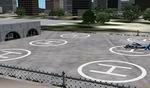
FS2002
Sth Louisiana 'Rescue' Scenery #1 by C.Young. First in series
located in the New Orleans and South Louisiana area. . Two Pads
at New Orleans Lakefront Airport. 3. US Coast Guard Station
on the Lake east of New Orleans International. This has a map
entry, NDB 432 and an ILS approach to the helipad on 111.25.
5. Helipad North of the Lake at Slidel, La. Airport(KASD). 12.
East Jefferson Hospital east of Petrocomm NDB 354. 46. Crash
of PanAM Flight 759 east of KMSY. (July 9,1982) 47. Slidel Memorial
Hospital north side of Lake Pontchatrain NDB 399. 1.3MB
Posted Jun 23, 2008 14:31 by archive