
(309 downloads)
FS2002
Albuquerque Sunport (KABQ) South Air Freight Ramp
This package contains a fair representation of the South Cargo/Air
Freight complex on the south end of Albuquerque's Sunport International
Airport. This new Air Freight complex opened a few years ago
and operates daily, running cargo into and out of New Mexico
in support of companies such as Eclipse Aviation, Rockwell,
Sandia and Los Alamos National Labs, Kirtland AFB, Intel Corp,
and also carries the art and goods made in this area to the
world (hello Santa Fe Style!). Also includes ramp lights, ground
support equipment, vehicles, and various cargo pieces waiting
for you on the ramp. Also has a few other pieces of eye candy.
Custom signage is modifiable for your VA's logo sign, giving
you an Air Freight home in the Great Southwest. This location
has night-lighted textures with a start location which can be
found using the add on scenery button on your Go To Airport
menu. 930K
Posted Jun 23, 2008 14:31 by archive

2.93Mb (586 downloads)
FS2002
EDHG Includes
the airfield in Lüneburg, southeast of Hamburg in Northern Germany
(Niedersachsen). Custom objects are mainly replaced by macros
edited by the authors. "EDHG03e.exe" will guide you through
the installation process. By Sacha Lindenberg and Arne E. Ehlers.
3MB
Posted Jun 23, 2008 14:31 by archive

22.04Mb (668 downloads)
FS
2002 Randolph AFB,Texas Scenery Package.
This scenery is of Randolph AFB located near San Antonio, Texas.
RAFB has great historical significance for the U.S. Air Force.
It was built in the early 1930s to fulfill a need for a pilot
training facility. Most of the original buildings were designed
in the Spanish Colonial Revival style. For many years from the
'30s to the '60s it was the main site of the Army Air Corps'
(and then Air Force) Aviation Cadet program. It is still active
today, with pilot training programs in the Cessna T-37, T-38
Talon, and now the T-6 Texan II. This scenery has been years
in the making, with great attention paid to detail, and many
of the building textures were taken from digital photography.
The night lighting of the base and adjacent cities was designed
to be as realistic as possible, especially in the area of street
lighting. The landing approach to runways 14 left or right is
especially dramatic at night as you fly low over Universal City.By
James Shaddox. 23MB
Posted Jun 23, 2008 14:31 by archive

0.74Mb (679 downloads)
Elmendorf
AFB, Anchorage, Alaska.
Package For FS2002. This scenery adds a more detailed and accurate
depiction of Elmendorf AFB in Anchorage, using satellite photos
and personal experiences. Included also is the addition of Bryant
AHP, a helicopter airfield at Ft. Richardson (next to Elmendorf)
which was also made using satellite photos and personal experiences.
These airbases are some of the most active and important in
the country. Includes full and acurate night lighting. By Matt
Magner. 781K
Posted Jun 23, 2008 14:31 by archive

1.49Mb (424 downloads)
AFCAD
and flightplans for 47 airports in B.C.
Many small airports in southern and central British Columbia,
neglected by FS2002, come to life with this package. Even if
you're not interested in B.C., check out my templates and instructions
for making 7 add-on planes, including the DHC2 Beaver, Pitts
S-1S, and BushHawk-XP, usable as AI in any flight plan! Step-by-step
guide for people unfamiliar with AFCAD and Traffic Tools (both
available here) . By Holger Sandmann. 1.5MB
Posted Jun 23, 2008 14:31 by archive
4.98Mb (405 downloads)
76-m
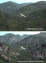
Mesh of B.C.'s Monashee-Selkirk Region New high-resolution mesh
of two mountain ranges in south-central British Columbia (N49-51,
W117-118.5), from the U.S. border to Revelstoke. Visit the steep
valleys and high alpine areas enclosed by Slocan Lake and the
Arrow Lakes. Made from 50-m digital elevation data, resampled
to LOD9 (76-m). Use as add-on to my LOD7 (306-m) mesh or independently.
By Holger Sandmann. 5.1MB
Posted Jun 23, 2008 14:31 by archive
5.35Mb (450 downloads)
76-m
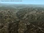
Mesh of B.C.'s Lillooet-Thompson Region 30,000 square km of
southwestern British Columbia (N50-51,
W120-124) in vivid detail. One of the most spectacular regions
of the province: Visit the Fraser and Stein River canyons, Princess
Louisa Inlet, and the lakes in the Pemberton area. Made from
50-m digital elevation data, resampled to LOD9 (76-m). Use as
add-on to my LOD7 (306-m) mesh or independently. By Holger Sandmann.
5.4MB
Posted Jun 23, 2008 14:31 by archive
0.60Mb (331 downloads)
Patches
for my LOD7/9 Terrain Meshes of BC.
Patches (flatten files) for 108 lakes in British Columbia and
Southeast Alaska that were either sunken below or raised above
the terrain surface due to discrepancies between my add-on LOD7
and LOD9 mesh files and FS2002's default scenery. Also included
are flatten files for nine airfields that had problems with
sloping terrain or texture "bleeding". By Holger Sandmann. 614K
Posted Jun 23, 2008 14:31 by archive
6.24Mb (617 downloads)
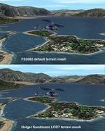
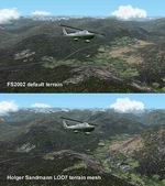
New 300-m
(LOD7) Terrain Mesh of British Columbia and Southeast Alaska.
Mid-resolution (300-m) terrain mesh for the entire province
of British Columbia (950,000 square km) and the Alaska panhandle
southeast of N60 W139. Made from 250m-resolution source data
without oversampling. Easy on frame rates and hard drive space.
It transforms the rounded mountains of the default terrain
mesh into a much more realistic representation of the diverse
topography of this beautiful corner of the world. Experience
the spectacular scenery between Vancouver and Atlin, Juneau
and Fort St. John, and Mount Robson to Clayoquot Sound. Fourteen
independent mesh tiles allow you to select the region(s) you
like best. Several high-resolution add-on meshes will be uploaded
separately. By Holger Sandmann.
Part
1 of 4: All areas north of 57 degrees. 6.3MB
Part
2 of 4: All areas between 54 and 57 degrees North. 6MB
Part
3 of 4: All areas between 51 and 54 degrees North. 5.9MB
Part
4 of 4: All areas between 48 and 51 degrees North. 6.5MB
Posted Jun 23, 2008 14:31 by archive
(268 downloads)
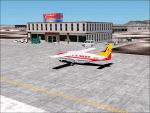
Zia
Air Cargo New Mexico Short Routes Package.
This package contains an office and ramp areas at 21 New Mexico
(and Colo/Az) airport ramp locations for Zia pilots. Each location
has a Zia office, ramp lights, ground support equipment, vehicles,
and various cargo pieces waiting for you on the ramp. Also has
a few other pieces of eye candy. Airport locations include Albuqueruqe,
Alamosa, Alamogordo, Carlsbad, Clovis, Demming, Durango, Co.,
Farmington, Gallup, Hobbs, Las Vegas, NM, Las Cruces, Raton,
Roswell, Silver City, Socorro, Springerville, Az., Taos, Telluride,
Co., Truth or Consequences, and Tucumcari. Alllocations have
night-lighted textures with a start location which can be found
using the add on scenery button on your Go To Airport menu.
4.4MB
Posted Jun 23, 2008 14:31 by archive


