


124.63Mb (510 downloads)
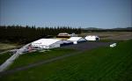
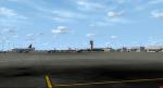
A freeware scenery of the Norwegian airfield Jarlsberg. The scenery includes photoreal ground, custom ground poly, and custom 3D buildings. Seasons included. Marius Risan
Posted Aug 31, 2019 04:31 by uploader
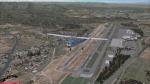
21.46Mb (696 downloads)
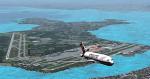
This is the new KAVL, Asheville Regional Airport.
Runway 34-16 has been closed for upgrade and a temporary runway 35-17 has been opened in the meantime.
Photoreal textures for day night and snow are included.
Posted Aug 30, 2019 04:01 by D Goldsmith
7.20Mb (410 downloads)
KBWG, Bowling Green-Warren County Regional Airport, Kentucky USA, scenery for FSX.
An ADE upgrade of the FSX stock airport with photoreal background. Tested in FSX but may also work for P3D.
Tim van Ringen
Posted Aug 28, 2019 03:43 by uploader
16.36Mb (2183 downloads)
SBGL, Rio De Janeiro Galeao Airport, Brazil, scenery for FSX.
An ADE upgrade of the FSX stock airport, now with a photoreal airport background and made more lively. Also downscaled a few buildings that ware too big i.m.h.o. Tested only in FSX but may also work in P3D.
Tim van Ringen
Posted Aug 28, 2019 03:43 by uploader
150.93Mb (737 downloads)
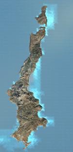
Greece - Karpathos photoreal scenery for FSX. Day & Night. Karpathos, also Carpathos, is the second largest of the Greek Dodecanese islands, in the southeastern Aegean Sea. Dimitris Ntaskas
Posted Aug 27, 2019 05:02 by uploader
124.77Mb (688 downloads)
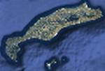
Greece - Kos photoreal scenery for FSX. Day & Night. Kos, one of Greece’s Dodecanese islands, is known for its abundant sandy beaches. It’s also rich with Greek and Roman landmarks, particularly in and around Kos Town. Dimitris Ntaskas
Posted Aug 27, 2019 04:58 by uploader
4.74Mb (1198 downloads)
Completely new setup with photoreal background, done with SBuilder and ADE. Faro Airport or Algarve Airport is located at the south of Portugal. It is mainly used from March to October for tourist flights. By Tim Van Ringen
Posted Aug 27, 2019 04:12 by uploader
8.72Mb (796 downloads)
ADVICE: BACK UP original files in case you do not like these textures!!!
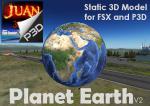
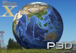
Planet Earth's static 3D model V2 - by juan30005 for: Flight Simulator X & Prepar3D.
This package contains the model of Planet Earth and texture high quality 4096 x 2048 px this version v2 includes textures bump and spec.
FSX install model: copy content. ..\Microsoft Flight Simulator X\Addon Scenery\ scenery and texture.
-----------------
add the model to scenery with: Object Placement Tool , save scenery file (.xml)
agrega el modelo al escenario usando: Object Placement Tool
compila en bgl con "BGL Compiler SDK".
P3D install model: copy content. ..\Prepar3D v4\Scenery\Global\ scenery and texture.
Add the model to scenery with: SimDirector, or you can also use Object Placement Tool and then pass it to P3D.
Watch this video, this teaches you how to add the models of the scenery
Tutorial FSX: efectos y object placement tool
https://youtu.be/W1KCvqQja4Y.
Posted Aug 25, 2019 16:30 by juan30005
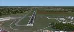
33.12Mb (624 downloads)
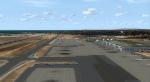
Kalamata airport (LGKL), Greece.Updated to v1.02
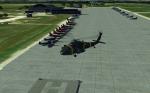
This is my 2nd freeware scenery so far. This is Kalamata airport (LGKL), Greece. Southwest Peloponnese region, with photoreal scenery texture. It's located west side of Sparta (99 kilometers away) separated my the mountain of Taigetus. Airport opened in 1959 and is basicaly 2 airports in 1. It was started as military and a few years later, civilian flights began to operate. Airport is using objects from "airfield essentials", "orbx grass", "static military models" and "TKB object library" ... so ALL thanks goes to them for the models. This airport will work better in P3D4 because i use the "dynamic lighting" effect. Keep in mind that orbx is needed, or else the grass textures aren't goin to work... I 'am not sure about FSX though, i don't think it will work there....
Posted Aug 25, 2019 07:21 by Dimitris Mylonas
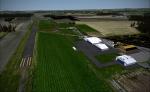
298.35Mb (158 downloads)
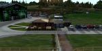
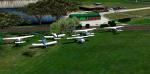
Bembridge airport in Bembridge, Isle of Wight, England, has gone quiet over the past few years, since they lost their CAA license the airfield no longer offers flights to the public or flight instruction. This scenery has been rebuilt to work with our Sandown scenery, you have one you may want the other.
Posted Aug 24, 2019 00:42 by Mark Piccolo - Soarfly Concepts