
527.63Mb (916 downloads)
Rheine Eschendorf, a German grass airfield in the north-west, near Münster and Osnabrück. High detail scenery package. Tested with FSX, FSX:SE, P3D V3 and P3D V4. Johannes Schuster and Jens Hicken.
Posted Jun 12, 2017 08:49 by Jens Hicken


2.25Mb (431 downloads)
RAF Rufforth was built by John Laing & Son Ltd for the Royal Air Force in 1941 (completed 1942), it is located on the south side of the village.[1]
The airfield had one B1 and two T2 hangars and 36 aircraft hard standings and there was accommodation for 1,531 males and 251 females of all ranks.[2]
The ITV fictional drama series "Airline" was partially filmed at the airfield in 1982.
Be sure to uninstall any Rufforth scenery before installing this Package
Posted May 26, 2017 09:54 by Terry Boissel

120.31Mb (1836 downloads)
CYYJ (2017), Version 7, is a major upgrade to CYYJ (2014). It portrays the Victoria (British Columbia, Canada) International Airport (CYYJ), aviation museum, Pat Bay floatplane base (CAP5) and Coast Guard station, and nearby industrial park as they appeared in early 2017 - as well as a host of static aircraft. It is fully compatible with Victoria+ (both FS2004 And FSX versions), Ultimate Terrain Canada/Alaska for FS2004 and Ultimate Terrain X - Canada for FSX, ORBX's FTX NA Blue and other FS9 road and shoreline upgrades for the area. CYYJ (2017) includes aircraft and traffic files for a realistic AI scenario other than scheduled airline operations. (Use BC Regional AI - also available from this file library - for scheduled traffic). Version 7 adds all the recent major new construction and apron expansion at CYYJ, and includes a greater level of detail in many areas.
Posted May 24, 2017 13:41 by Don Grovestsine


3.13Mb (322 downloads)
RAF Predannack was opened in May 1941 as a satellite for RAF Portraits. Accommodation was dispersed over a wide area, with officers accommodated in the Mullion Cove and Polurian Hotels. The number of personnel reached peak strength of 3,600 by 1944.
The first squadron to arrive was 247 Squadron with Hawker Hurricanes, specialising in night defence of the South West's towns and ports. The night fighting element was later augmented by 1457 Flight flying Douglas Havocs with its unsuccessful Turbinlite searchlight tactics. However, the arrival of 600 Squadron with radar equipped Bristol Beaufighters produced better results. GCI (Ground Control Interception) in the area was covered by RAF Treleaver radar station.
A more detailed history can be found on Wikipedia.
Posted May 17, 2017 06:20 by Terry Boissel


45.16Mb (503 downloads)
FSX/P3D Scenery - Skive Airport EKSV
Danish VFR airport 10 km southeast of
Skive city, in the middle of Jutland in
Denmark. Airport has lighted asphalt runway
so can be used 24 hours.I have designed it
with photoreal background, with summer
and winter seasons. It has animated wind-
socks and wind gauges. All objects are
designed in FSDS except for a few ones.
By Otto Knudsen
Posted May 12, 2017 12:44 by uploader

45.16Mb (361 downloads)
FSX Scenery-- Skive Airport EKSV
Danish VFR airport 10 km southeast of
Skive city, in the middle of Jutland in
Denmark. Airport has lighted asphalt runway
so can be used 24 hours.I have designed it
with photoreal background, with summer
and winter seasons. It has animated wind-
socks and wind gauges. All objects are
designed in FSDS except for a few ones.
By Otto Knudsen
Posted May 9, 2017 07:23 by Otto Knudsen


232.40Mb (1582 downloads)
This package contains autogen and inland water for FTXDes orthoscenery of Slovenia: Project Open Scenery - Slovenia.
Posted May 1, 2017 04:29 by Milan Smid


651.08Mb (916 downloads)
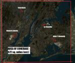
FSEarthtiles photo-real New York metro area with Water-mask overlay. Technique instructions included in readme. Approx. 537 square miles. No autogen or night textures - not tested with DX-10 or P3D.
Posted Apr 29, 2017 21:08 by Jim Waters


9.85Mb (951 downloads)
FSX/P3D Scenery German Navy Base (Marinestützpunkt) Flensburg Muerwick in the 70th. The scenery consist of the Marine harbor with its barracks, the castle with the Marine school and the Marine yacht club. It is proposed to be combined with the great tool "AiCarriers2" which will set up to ten ships in the harbor. An AiCarriers2 configuration plus five of my 70th Navy ai-ships are included. There is also a saved flight with the proper coordinates in the harbor included. My own pilotable ship is the "Saar" (package-minesweeperfleet.zip) on which I served that time. Scenery by Erwin Welker.
Posted Apr 16, 2017 05:09 by Erwin Welker

215.86Mb (344 downloads)
Fort Wayne International Airport, KFWA, Indiana, USA,
version 1.1 for P3D.
This is a detailed rendition of Fort Wayne International Airport, Indiana, USA. The airport is a regional airport serving Northeast Indiana and is also the home of the USAF 122nd Fighter Wing Indiana ANG.
The airport was originally named "Baer Field" as a World War II military base. During World War II more than 100,000 military personnel served at the airport. Shehryar 'Shez' Ansari
Posted Apr 9, 2017 03:05 by Mike Leitz


