


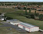
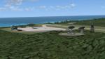
16.70Mb (1964 downloads)
Scenery of Bar-le-Duc (France) and its
LFEU airfield a few miles south of Verdun.
HiRes photoreal ground with seasonal and
night variants. bumpy and sloped runway.
Detailed hangars (specular, bump materials,
smoke effects), animated windsock, static
planes, nearest village all in 3D, cars,
trucks, and the nearest windfarm of 33
animated and lightedwindturbines.
VAC chart included. By D. Bur.
Posted Nov 24, 2011 05:26 by D. Bur
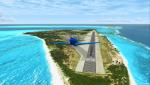
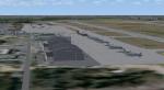
17.23Mb (5425 downloads)
This scenery is dedicated to Bob. Midway Atoll - or Midway Islands as it is often called - is a tiny Atoll at the
northwestern end of the Hawaiian Islands chain. It lies halfway between Asia and North America which made it an ideal
refueling stop on transpacific flights. Henderson Airfield on Sand Island has a 8,000 ft runway which is ideal for all
kinds of heavy metal.
Texture resolution is 1m/pixel (LOD 15). Package comes with a simple runway and taxiways and basic airport autogen.
By Tiberius Kowalski.
Posted Nov 22, 2011 02:43 by Tiberius Kowalski
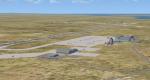
20.20Mb (1525 downloads)
Mount Pleasant EGYP - Falkland Islands - for FSX
This scenery is just an improvement on the default EGYP airport, Mount Pleasant, in the Falkland Islands. The default airport is just too bare. This is not a high-end scenery but, if you like long-haul flights, it will give you a far-away place to go and, when you get there, there will be an airport with some buildings and parked planes for you to see. For free distribution only. By Fern Marques.
Posted Nov 21, 2011 11:56 by Fern Marques
11.28Mb (2102 downloads)
Ascension Island for FSX
This scenery is for FSX only. It is not a high-end scenery package. This is just an improvement on the Ascension Island that comes with FSXh(Wideawake Airport, FHAW). It has some specific traffic, and the airplanes required to make it work are included. It also includes the Brize Norton airport, Oxford, UK, in case you don't have a better one, because the default Brize Norton doesn't have appropriate parking for the AI traffic aeroplanes. For distribution at no-charge only. Scenery and planes by Fern Marques.
Posted Nov 20, 2011 16:05 by Fern Marques
44.90Mb (4822 downloads)
The home of Airforce One. Located near: Camp Springs, Maryland.
This is a scenery package for the Andrews Base by Uwe Kunzak, adapted with his permission for FSX. Updated package for FSX from the original by Uwe Kunzak. It is a beautiful job by Uwe, and it is a great replacement for the rather poor Andrews that comes with FSX. For distribuition at no charge only. Uploaded by Fern Marques.
Posted Nov 20, 2011 11:36 by Fern Marques
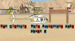
2.52Mb (427 downloads)
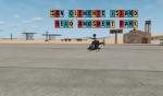
Created for San Clemente island and is the 2nd part of the Infamous Helo Amusment park scenery but this is phase 2 and has more of thise Animated helo pads and other Eye candy. Created some padds that Spin and some that run on a elivated rail and move from left to right.I also place a Ski jump ramp for larger aircraft to help them get off the runway.
Posted Nov 19, 2011 18:03 by Jim Abbey
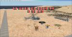
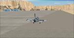
3.19Mb (451 downloads)
A fictional amusement park for some interesting and challenging helicopter flying! Features elevated and animated helo pads with custom hangers, Jim's paint shop and Harry's Diner.
I also included a bombing range on the hill and much more! Created with Flight sim Design Studio V3,5 and ADE using SDK.
Posted Nov 18, 2011 16:34 by Jim Abbey
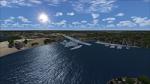
22.92Mb (638 downloads)
This is my first scenery project that I have completed. This is just a medium lake out in Kentucky that i did. I changed the shape of the lake to be the same as in real-life. I added static boats and birds to the mix as well. The readme in the file explains more about what I did. I hope you enjoy the scenery. It makes the lake look alot better!
Posted Nov 16, 2011 16:43 by The Emerald Pilot Club
0.70Mb (442 downloads)
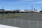
CFB North Star detail modification patch (version 7.2) for FSX. Requires CYNS_v7_FSX.zip. Adds overhead lighting to parking areas, to create a more busy look. Raw source files are also included for use in any freeware projects. FREEWARE by Brian Sturton.
Required files:
required file
Posted Nov 16, 2011 14:16 by Brian Sturton
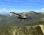
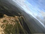
314.51Mb (2167 downloads)
FSX Photo Scenery--Mt Washington And The Presidential Range, NH. Welcome to the Presidential Range in the White Mountains of northern New Hampshire. At 6288 feet, Mount Washington's summit is the highest peak in the northeast. The download includes an on orientation guide with an imbedded map notes nearby airports, etc. in web format. Installation instructions are included. By Richard Sorochak.
Posted Nov 16, 2011 07:14 by Richard Sorochak