


1.24Mb (12497 downloads)
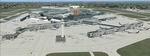
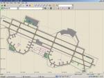
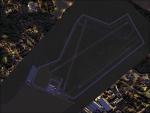
London Heathrow International Airport - EGLL. EGLL_KA.bgl is a significant modification to the FSX default EGLL. Version 1 represents EGLL as it existed in February 2009. See Readme for detailed information. By Kambiz Agazi
Posted Jul 17, 2009 07:22 by Kambiz Agazi
52.97Mb (1918 downloads)
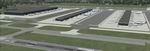
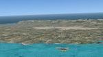
FSX Scenery--90 Mile Beach X. 2.5 meter photoreal scenery of 90 mile beach, New
Zealand. This area can be found at the top of the North Island and is a awesome
place to visit in the sim and in the real world. By Michael Allen-Andrews.
Posted Jul 16, 2009 13:05 by Michael Allen-Andrews
5.63Mb (3508 downloads)
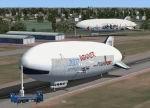
FS2004/FSX FlightPort Zeppelin NT AI-Traffic.
This is an AI only aircraft. The Zeppelin_AI was built with FSDS3.5. Model is multi-LOD and comes with four repaints, repaintset and separate HeliTraffic 2009 files. To optimize frames, there are only DXT3 textures with mipmaps included. Also great to display multiplayer on online flights. By Thomas Roehl, Joerg Hammes and Stefan Medelnik.
Posted Jul 16, 2009 11:27 by Thomas Roehl
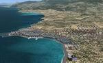
31.14Mb (4003 downloads)
Crete Island, Greece, Package V2. In this second version I have used the mesh terrain of Yiannis Dermitzakis that
offers a bigger realism to the costs This has put under an obligation to reconstruct
the entirety of the populations of the since costs they were located inside the
sea. At the same time I have been able to redraw them populations with houses
and real facilities that Google Earth has facilitated me . I have also obtained
of Roger Politis dear collaboration one that knows that land very well
I believe that I can offer a quite realistic scenery especially in the group of
populations of the coast. Toni Agramont
Posted Jul 15, 2009 12:58 by Toni Agramont
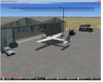
1.38Mb (1324 downloads)
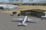
This scenery package adds an air cargo hangar to the default scenery for Provo Municipal, KPVU (Provo, Utah).
Other scenery that I've designed includes:
* a hangar and vehicles placed at Hobbs, NM (KHOB)
* a hangar and vehicles at Farmington, NM (KFMN)
Anyone interested in flying cargo between these destinations will enjoy this scenery. I routinely fly these routes.
Simply copy the bgl file to ...Microsoft Flight Simulator X/Addon Scenery/Scenery folder.
Coming soon: Airshow scenery at Otis Air National Guard Base, Massachusetts!
I would like to thank John Stinstrom for his Green Ground Service Equipment which I downloaded; I've used a couple of objects he designed in this scenery.
If you have problems with this add-on, please contact me at javajoe06@yahoo.com.
Posted Jul 15, 2009 12:22 by Joe Hassen
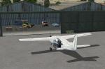
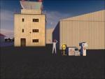
1.13Mb (774 downloads)
This scenery package adds an air cargo hangar to the default scenery for Four Corners Regional, KFMN (Farmington, NM).
Other scenery that I've designed includes:
* a hangar and vehicles/air cargo objects placed at Hobbs, NM (KHOB)
* a hangar and vehicles/air cargo objects placed at Provo, UT (KPVU)
Anyone interested in flying cargo between these destinations will enjoy this scenery. I routinely fly this route. The takeoff from Farmington's Runway 25 is an enjoyable one, especially when loading your Caravan to max takeoff weight!
Simply copy the bgl file to ...Microsoft Flight Simulator X/Addon Scenery/Scenery folder.
If you have problems with this add-on, please contact me at javajoe06@yahoo.com.
Posted Jul 15, 2009 12:17 by Joe Hassen
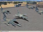
1.40Mb (1812 downloads)
Complete new Update Afcad and Scenery fix for LGSA- Chania - Souda Airbase Crete.
Special thanks to Roger Politis for Beta testing over the weeks.
Static F16 With kind permission and thanks to Guy Diotte who repainted in HAF Aegean Ghost Scheme for this scenery.
Copy LGSA folder into Addon Scenery folder and activate in the usual way.
I would welcome anyone to improve on the Terminal buildings as I have only used all default library items and would willingly delete them for more accuracy – please feel free to contact me if required.
Enjoy.
Posted Jul 14, 2009 17:31 by alan mmcarthy
1.45Mb (815 downloads)
Places an Air Cargo Hangar along with some ground vehicles and airplanes at KHOB (Lea County Regional), New Mexico.
Posted Jul 14, 2009 13:25 by Joe Hassen
2.14Mb (1104 downloads)
***Ashcroft Airfield, Wettenhall, Cheshire, UK (EGCR)***
This is the first time I've made an airfield/airport so feedback (good or bad) is appreciated.
This is my local field that wasn't included with FSX so I thought I'd try and make it.
Feel free to distribute this file as you wish but please mention WWW.TBFSS.COM if the file is hosted else where.
Posted Jul 11, 2009 22:52 by Roo
0.54Mb (1674 downloads)
Only for FSX. Replaces all previous versions. Created with Airport Design Editor.The challenge is finding the cruise and ship sailing between the mainland and Robinson Crusoe
Posted Jul 11, 2009 13:45 by Juan Lucero