


75.68Mb (1060 downloads)
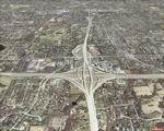
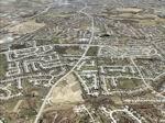
FSX St Louis PhotoReal Scenery. This is high resolution, 1 meter/pixel, terrain scenery for St Louis, Missouri (MO). Section, N, is one of 30. A map and descriptions show the section locations and some feature details. This photoscenery is for DAY USE ONLY and will work for any season, but shows only the USGS aerial photo data taken in March 2002. The default FSX mesh works well with this photoscenery and no additional mesh for the area needs to be purchased. The 30 sections of scenery, totalling 2 Gb, contains photoreal terrain textures, encompassing an area bounded by 31.7 E-W and 27.4 N-S miles (about 870 square miles). Each section is independent, but the user may want most or all sections to provide continutiy and completeness. By Jim Jones
Posted Oct 7, 2008 19:16 by Jim Jones
72.81Mb (1040 downloads)
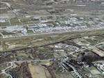
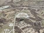
FSX St Louis PhotoReal Scenery. This is high resolution, 1 meter/pixel, terrain scenery for St Louis, Missouri (MO). Section, M, is one of 30. A map and descriptions show the section locations and some feature details. This photoscenery is for DAY USE ONLY and will work for any season, but shows only the USGS aerial photo data taken in March 2002. The default FSX mesh works well with this photoscenery and no additional mesh for the area needs to be purchased. The 30 sections of scenery, totalling 2 Gb, contains photoreal terrain textures, encompassing an area bounded by 31.7 E-W and 27.4 N-S miles (about 870 square miles). Each section is independent, but the user may want most or all sections to provide continuity and completeness. By Jim Jones.
Posted Oct 7, 2008 19:15 by Jim Jones
73.22Mb (1099 downloads)
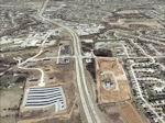
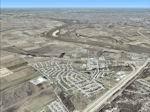
FSX St Louis PhotoReal Scenery. This is high resolution, 1 meter/pixel, terrain scenery for St Louis, Missouri (MO). Section, G, is one of 30. A map and descriptions show the section locations and some feature details. This photoscenery is for DAY USE ONLY and will work for any season, but shows only the USGS aerial photo data taken in March 2002. The default FSX mesh works well with this photoscenery and no additional mesh for the area needs to be purchased. The 30 sections of scenery, totalling 2 Gb, contains photoreal terrain textures, encompassing an area bounded by 31.7 E-W and 27.4 N-S miles (about 870 square miles). Each section is independent, but the user may want most or all sections to provide continuity and completeness. By Jim Jones.
Posted Oct 7, 2008 13:55 by Jim Jones
51.15Mb (992 downloads)
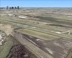
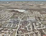
FSX St Louis PhotoReal Scenery. This is high resolution, 1 meter/pixel, terrain scenery for St Louis, Missouri (MO). Section, DD, is one of 30. A map and descriptions show the section locations and some feature details. This photoscenery is for DAY USE ONLY and will work for any season, but shows only the USGS aerial photo data taken in March 2002. The default FSX mesh works well with this photoscenery and no additional mesh for the area needs to be purchased. The 30 sections of scenery, totalling 2 Gb, contains photoreal terrain textures, encompassing an area bounded by 31.7 E-W and 27.4 N-S miles (about 870 square miles). Each section is independent, but the user may want most or all sections to provide continuity and completeness. By Jim Jones.
Posted Oct 7, 2008 13:44 by Jim Jones
75.02Mb (933 downloads)
FSX St Louis PhotoReal Scenery. This is high resolution, 1 meter/pixel, terrain scenery for St Louis, Missouri (MO). Section, D, is one of 30. A map and descriptions show the section locations and some feature details. This photoscenery is for DAY USE ONLY and will work for any season, but shows only the USGS aerial photo data taken in March 2002. The default FSX mesh works well with this photoscenery and no additional mesh for the area needs to be purchased. The 30 sections of scenery, totalling 2 Gb, contains photoreal terrain textures, encompassing an area bounded by 31.7 E-W and 27.4 N-S miles (about 870 square miles). Each section is independent, but the user may want most or all sections to provide continuity and completeness. By Jim Jones.
Posted Oct 7, 2008 10:57 by Jim Jones
71.15Mb (985 downloads)
FSX St Louis PhotoReal Scenery. This is high resolution, 1 meter/pixel, terrain scenery for St Louis, Missouri (MO). Section, C, is one of 30. A map and descriptions show the section locations and some feature details. This photoscenery is for DAY USE ONLY and will work for any season, but shows only the USGS aerial photo data taken in March 2002. The default FSX mesh works well with this photoscenery and no additional mesh for the area needs to be purchased. The 30 sections of scenery, totalling 2 Gb, contains photoreal terrain textures, encompassing an area bounded by 31.7 E-W and 27.4 N-S miles (about 870 square miles). Each section is independent, but the user may want most or all sections to provide continuity and completeness. By Jim Jones.
Posted Oct 7, 2008 10:54 by Jim Jones

65.82Mb (1113 downloads)
FSX St Louis PhotoReal Scenery. This is high resolution, 1 meter/pixel, terrain scenery for St Louis, Missouri (MO). Section, B, is one of 30. A map and descriptions show the section locations and some feature details. This photoscenery is for DAY USE ONLY and will work for any season, but shows only the USGS aerial photo data taken in March 2002. The default FSX mesh works well with this photoscenery and no additional mesh for the area needs to be purchased. The 30 sections of scenery, totalling 2 Gb, contains photoreal terrain textures, encompassing an area bounded by 31.7 E-W and 27.4 N-S miles (about 870 square miles). Each section is independent, but the user may want most or all sections to provide continuity and completeness. By Jim Jones.
Posted Oct 7, 2008 09:58 by Jim Jones
59.20Mb (1022 downloads)
FSX St Louis PhotoReal Scenery. This is high resolution, 1 meter/pixel, terrain scenery for St Louis, Missouri (MO. Section, BB, is one of 30. A map and descriptions show the section locations and some feature details. This photoscenery is for DAY USE ONLY and will work for any season, but shows only the USGS aerial photo data taken in March 2002. The default FSX mesh works well with this photoscenery and no additional mesh for the area needs to be purchased. The 30 sections of scenery, totalling 2 Gb, contains photoreal terrain textures, encompassing an area bounded by 31.7 E-W and 27.4 N-S miles (about 870 square miles). Each section is independent, but the user may want most or all sections to provide continuity and completeness. By Jim Jones.
Posted Oct 7, 2008 09:56 by Jim Jones
69.45Mb (1083 downloads)
FSX St Louis PhotoReal Scenery. This is high resolution, 1 meter/pixel, terrain scenery for St Louis, Missouri (MO). Section, AA, is one of 30. A map and descriptions show the section locations and some feature details. This photoscenery is for DAY USE ONLY and will work for any season, but shows only the USGS aerial photo data taken in March 2002. The default FSX mesh works well with this photoscenery and no additional mesh for the area needs to be purchased. The 30 sections of scenery, totalling 2 Gb, contains photoreal terrain textures, encompassing an area bounded by 31.7 E-W and 27.4 N-S miles (about 870 square miles). Each section is independent, but the user may want most or all sections to provide continuity and completeness. By Jim Jones.
Posted Oct 7, 2008 08:18 by Jim Jones
67.01Mb (1061 downloads)
FSX St Louis PhotoReal Scenery. This is high resolution, 1 meter/pixel, terrain scenery for St Louis, Missouri (MO). Section, A, is one of 30. A map and decriptions show the section locatons and some feature details. This photoscenery is for DAY USE ONLY and will work for any season, but shows only the USGS aerial photo data taken in March 2002. The default FSX mesh works well with this photoscenery and no additional mesh for the area needs to be purchased. The 30 sections of scenery, totaling 2 Gb, contains photoreal terrain textures, encompassing an area bounded by 31.7 E-W and 27.4 N-S miles (about 870 square miles). Each section is independant, but the user may want most or all sections to provide continutiy and completeness. By Jim Jones.
Posted Oct 7, 2008 08:16 by Jim Jones