


1.09Mb (8170 downloads)
FSX
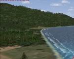
More Waves III. The surf arrives to FSX! Improved coastal
breakers with more waves, to move like the surf on shallow waters.
Updated version for and tested only in FSX. By Luiz Alvarenga.
Posted Jun 23, 2008 14:16 by archive

0.46Mb (5747 downloads)
FSX
USS Carrier Saratoga CV-3
This is a true FSX scenery object compiled with Xtomdl. It features
an exact shape hard deck for carrier ops with airplanes equipped
with rcbco-30 (not included). It also has a smoke effect, ship
wake and a rotating beacon. A night texture is included for
night carrier ops. It is located just outside Pearl Harbor.
The files necessary to move it to other locations with the FSX
SDK Bglcomp program are included. By Paul Clawson. 474K
Posted Jun 23, 2008 14:16 by archive
80.23Mb (3657 downloads)
FSX
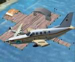
Caribbean Seaplane Tours“Caribbe West” Scenery
Package.
Introduction: . It is a fictional airlines based on “Real
World” places. Grand Cayman Islands - Grand Cayman -
This scenery includes both the Airport, Harbor and SeaPlane
Docks…See NAV Aids for locations Cayman Brac - Located
East of Grand Cayman, the scenery includes both the airport
and SeaPlane Dock Little Cayman - Located approximately 20
miles east of Cayman Brac, scenery includes both airport and
seaplane dock. Jamaica - Montego Bay - Includes Sangsteer
International Airport and a seaplane dock. Negril - Located
on the Southwestern tip of the island the scenery includes
the Aerodrome, Harbor, and seaplane docks. Kingston - Scenery
includes Tinson Pen Airport and Port Royal SeaPlane Dock.
Mexico - Cancun - This scenery includes the Airport and SeaPlane
Dock. Chechen Itza - Located approximate 70 miles east of
Cancun, scenery includes, airport, scientific camp, and ruins…
Cozumel - Located south of Cancun, scenery include Airport,
seaplane dock and harbor. Roatan, Honduras - Small island
with airport and seaplane dock. Panama City, Panama. Scenery
includes the international Airport and SeaPlane Dock. Aruba
- Scenery includes the International Airport and SeaPlane
Dock. Curacao - Includes airport and seaplane dock Bonaire
- Scenery is located east of Curacao and includes the airport
and seaplane dock. La Orchila - Final Destination for Caribbe
West. Chris Carel. 82.1MB
Fix.
Like many of you, I went out and purchased FSX Acceleration....After
attempting to install, I realized I would have to do a clean
install. Once up and running, I was impressed by some of the
features, espically the new scenery and aircraft....But, I
was soon disappointed that most of my propeller aircraft had
"Alpha" Channel problems and that some scenery would
no longer show or had other scenery overtop of it. 30K
Posted Jun 23, 2008 14:16 by archive
0.02Mb (1023 downloads)
FSX
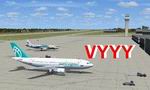
VYYY Yangon Intl Airport Mingaladon, Burma, V3.0
Yangon International Airport "MINGALADON" in Burma,
Myanmar, will be able to accommodate bigger aircrafts and handle
more passengers when work on extending its runway and upgrading
its facilities is completed. The completion of the runway extension
will enable Boeing 747 and Airbus 380 airplanes to use the airport.
The work on extending the runway from 8100 feet to 11,200 feet
began October 2004. FPS-friendly version 3.0 with already extended
runway, taxiways and new taxisigns. First of all we corrected
the airport location to the real one. With Myanmar Air Force
area, Helipads and even more parkings for civilian airplanes.
This scenery was produced based on pictures of satellites. Many
Thanks go to the teams of HOUSE-RP in Burma, FSX Planner, SceneGenX,
SBuilder X, Open Ports Scanner, AFXBgDownloader, FSUIPC and
Google Earth. This scenery is only for FSX, for FS2004 please
download vyyy_v2.zip (here).
By HOUSE-RP, Switzerland and Burma. 19K
Posted Jun 23, 2008 14:16 by archive

11.28Mb (10062 downloads)
FS2004/FSX
New Grass Textures.
After the success of TreeX, it was logical to improve the
ground of Flight Simulator. This is why PicNic was carried
out. But PicNic is much more than grass! It makes it possible
to improve the ground in general, giving to basic textures
an aspect more contrasted and also while bringing more relief.
PicNic functions on the photo-realistic scenes bringing an
additional dimension to them! It also makes it possible to
better appreciate its speed, making the flights at very low
altitude more alive. The pilots of helicopter will appreciate
the precision which PicNic during the operations of landing
and drives brings indeed of ground. Author: Aimé Leclercq.
11.5MB
Update/Fix:
Fixes
a reported problem with the PicNic Interface. 346K
Posted Jun 23, 2008 14:16 by archive
11.73Mb (9755 downloads)
FSX/FS2004
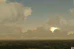
Alternative Runway, Asphalt, Concrete & Lightning Textures
Sets. "Spice Pak" offers summer, and winter textures
for RUNWAYS 11, 12, TAXI ASPHALT, and TAXI CONCRETE, and TAXIWAY
MARKS. It also contains HALO, 8kb SPOTLIGHT, LIGHTNING, FLASH,
and four samples of 64kb CUMULUS cloud textures...puffy, whispy,
dramatic, and cotton. Bring your coat or you may get frostbite
from my latest winter textures, and now hard surface summer
textures with weeds in cracks! Runway light scalar is also included.
Taste, and environment change from airport to airport, the enclosed
textures are fine tuned for the utmost realism, and performance!
This release also contains splash, and video. Kick it up a notch,
and add spice to your simulator, and put more flavor in your
flight experience! (Always Back up original Scenery
Textures before installing new). Brian Neitzel. 12MB
Posted Jun 23, 2008 14:16 by archive
9.67Mb (4734 downloads)
FSX
Seychelles Islands 2007.
This version includes changes that have occurred in the real
world since the previous version and includes new airports or
airstrips, new ground mesh, coasts, roads and rivers together
with new landclasses, waterclasses and various scenery objects
for the following islands: Coetivy, Platte, Darros, Remire,
Marie-Louise and Alphonse. The scenery included in the first
version i.e. Mahe, Silhouette, North Island, Praslin (and surrounding
smaller islands), Fregate, Denis Island and Bird Island has
also been amended. By Colin Penney. 9.9MB
Posted Jun 23, 2008 14:16 by archive
0.01Mb (1881 downloads)
FSX
Christchurch International Airport New Zealand.
I have changed a few of the taxiways and parking positions according
to how they are in real life.I have also made an apron and taxiways
to the Canterbury Aero Club like in real life.(the Canterbury
Aero Club is the buidlings and apron directly across the main
runway fro mthe main international airport terminal). Sadly
i could not get the actual Canterbury Aero Club buildings right
now, but i will work on it and see what happens, so if i do
get the actual aero club buildings then give them in an update
to this scenery package. 9K
Posted Jun 23, 2008 14:16 by archive
1.23Mb (6989 downloads)
FSX
Nick's SunFix Updated).
This package will enhance the sun effects in FSX and add simulated
volumetric light rays extending from the corona. It’s
designed to work with and without light bloom and be dynamic
with the time of day, altitude, clouds and the level of atmospheric
humidity content. The elements which light bloom enhance have
been reworked so bloom is not overpowering and should display
in proper scale. Nick Needham. 1.2MB
Posted Jun 23, 2008 14:16 by archive
15.07Mb (5061 downloads)
FSX
Madeira Archipielago, Spain.
The archipelago of Madeira this located in the middle of Atlantic
in the 32º 38N and 16º 50 W. belongs together to 978
kilometers of Lisbon address SW. To 545 kms to the W of the
end Djouchi in Morocco and to 443 kms to the north of Tenerife
in the Canary Islands. This archipelago is part of the Macaronesia
Ensemble of islands that the Açores, The Canary islands
of Cape Verde and the own Madeira; Funchal and I Porto Santo.
By Toni Agramont. 14.4MB
Posted Jun 23, 2008 14:16 by archive