


17.25Mb (1335 downloads)
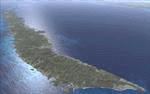
Version 3 includes all previous patches and updates. This version also restructures the file system to be fully compatible with the ORBX "FTX Global openLC North America" product as well as adding functionality for default FSX users. Additionally, water class scenery is updated to appear more realistic, MHRO is updated to reflect the newly expanded apron, and SRTMGL1 (30m) mesh is included. All landclass polygons and coastlines were meticulously hand-drawn directly from satellite imagery to provide the most detailed and accurate scenery available for this region. MHRO, GJAJ/MHNJ, and MHPL are completely overhauled and positioning is corrected. New and fully functioning AI airports are added for MHUT, MHFC, and MHCP, and MHLC is modified to accommodate more AI traffic.
Posted Dec 22, 2016 18:44 by Carlyle Sharpe
72.36Mb (839 downloads)
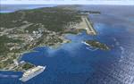
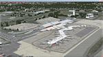
This is scenery for the Santa Rosa/ Sonoma County airport (KSTS).
It includes:
-Photorealistic Scenery (7cm- Airport Vicinity; 15cm- Surrounding towns.)
-AI and ATC compatible
-Includes the late 2014 runway extension/ airport modernization.
Posted Dec 18, 2016 00:18 by NorCal Scenery Guy
1.23Mb (866 downloads)
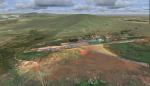
Tolmachevo Airport UNNT, Novosibirsk Russia, for FSX.
A simple remake, but way more accurate than the stock version, which is almost entirely wrong. The only additional files required is my Lights SS V2+ object library, but only if you don't already have it installed. If you don't already have it, you can download it here: By Sidney Schwartz
Required files:
required file
Posted Dec 11, 2016 08:03 by uploader
60.36Mb (458 downloads)
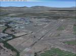
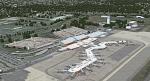
Eppley Airfield (KOMA) in Omaha, Nebraska updated for FSX to reflect the current state of the airport in 2016. AFCAD updated to include recent construction projects on the airport including runway extensions, terminal ramp extensions, as well as numerous taxiway layout changes. Gate parking information updated to reflect current gate usage. Photoreal coverage for Eppley Airfield extending south through downtown Omaha to Interstate-80 and west to Interstate-480, as well as numerous 3D models for downtown and parts of Creighton University.
Posted Dec 7, 2016 06:08 by uploader
164.59Mb (1821 downloads)
Detailed scenery of Richmond International Airport, Virginia, USA. This airport serves as the main airport for the capital city of the state of Virginia and is served by all the major US airlines.
Posted Dec 4, 2016 01:14 by Shehryar Ansari
14.96Mb (1409 downloads)
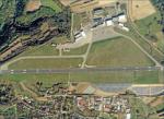
Photoreal scenery for Saarbrucken airport [EDDR], Germany. By flightsimulation-freeware
Posted Nov 26, 2016 06:06 by flightsimulation-freeware
10.54Mb (1001 downloads)
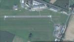
Photoreal scenery for Aachen-Merzbruck airfield [EDKA]. By flightsimulation-freeware
Posted Nov 26, 2016 06:02 by flightsimulation-freeware
4.12Mb (1050 downloads)
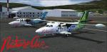
Nature Air AI 2016-2017 FS2004 / FSX package. Nature Air completes traffic pack (Costa Rica) AI for FS2004 and FSX. Includes the new Let 410 aircraft, textures, complete AI flight plans for high season 2016-2017 and instructions. Excellent for use with the Mega Costa Rica Pack and the landscape of Roberto J. Leiva. Designed by Santiago Spears
Posted Nov 21, 2016 20:17 by Santiago Spears
0.58Mb (186 downloads)
Here is the missing Airport terminal building for previous FSX-Chileka Int Airport Photoreal 20. (Below)
Posted Nov 19, 2016 15:50 by Peter M
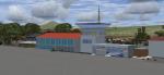
59.38Mb (419 downloads)
Photoreal scenery of Chileka Airport located in Blanytre, Malawi.
(See fix above)
Posted Nov 18, 2016 06:14 by Peter M