


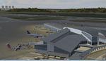
69.80Mb (654 downloads)
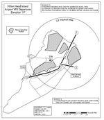
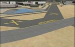
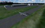
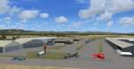
Scenery for 3 airports in the Savannah, Georgia area. This is a Scenery mod that completely rebuilds the 3 main airports in the Savannah GA area. Savannah International (SAV), Hunter AAF (SVN), and Hilton Head Island (HXD). Features include completely re-done from the ground up AFCADS to match current charts, Custom night lighting, Approaches updated to match current charts (As of 11/2015). Meany other special features detailed in the readme. Most importantly this is entirely self contained. No additional downloads required. Special procedures for operating at HXD are detailed in the readme. It's highly advised to read it.
Posted Nov 20, 2015 15:53 by CountryFlyboy
6.79Mb (1024 downloads)
LFCS is an airport Near Bordeaux in France. This is a fully functional freeware scenery for FSX and P3D. By Everlink
Posted Nov 19, 2015 12:08 by Everlink

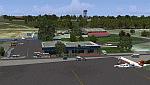
66.98Mb (531 downloads)
FSX Sonoma Co Airports, California. Most custom airports correct a lot of errors in runways and aprons but do not give a feel of the airport. Based on Google maps, pictures and visits to the airports, I have tried to add the feel of each airport in Sonoma County. This includes some unique buildings and planes to each airport, the runway rose, airport traffic patterns and IDs found on runways. By Mark J. S. Macaluso
Posted Nov 16, 2015 09:06 by Mike Lietz
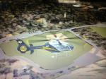
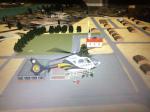
3.46Mb (371 downloads)
LCDR Ronald Wise Memorial Field - PABB - Boston, Pennsylvania
Boston Methodist Church - PABC - Boston, Pennsylvania
These two landing zones have been used in the past and currently still a suggested landing zones
for Elizabeth Township Fire Department of Pennsylvania. These two ball fields are situated in Boston, Pennsylvania
5nm South East of Allegheny County Airport. These fields are mainly used by STAT MedEvac and LifeFlight both Pittsburgh based
medical helicopter services. I used Google maps to layover satellite imagining and global coordinates to make these as accurate as possible. Please use README if need help with installation.
Posted Nov 14, 2015 12:31 by Z. Wojcik

45.37Mb (1098 downloads)
Sultan Ismail Petra Airport is located in north Malaysia and is our first HD release of a Malaysian airport.
This has been a bit of a challenge due to the poor imagery of the area but we have certianly pushed the limits to bring you the best possible rendition of the airfield.
Posted Nov 13, 2015 05:05 by Mark Piccolo - Soarfly Concepts
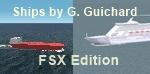
0.37Mb (1399 downloads)
That is a revisited version of our FS2002 tankers, liners, cruisers and ferries, to populate the maritime expanses in FSX. Using the FSX SDK TrafficDatabaseBuilder working with FSX default ships, you will reach to about 29,000 ships randomly navigating worldwide! Comes with a French readme too. Freeware
Posted Nov 12, 2015 09:09 by G. Guichard
1.96Mb (354 downloads)
That is a brand new, standalone version to our Terrains Around Dijon (needing a reinstall in case you would have any of our previous versions installed). The improvements we brought to our terrains needed such a stand-alone new 3.0! Comes with a French readme too. Freeware
Posted Nov 12, 2015 09:04 by G. Guichard
114.36Mb (3201 downloads)
Improved Realistic Sky and Cloud Textures(HDE).
Better Taxiways.
Improved Autogen Scenery(GEX).
To install - Copy and Paste texture folder and suneffect.cfg into the FSX root directory... If promped Replace ALL files in the Destination
Start Flight Simulator and Changes will be present
IMPORTANT! MAKE BACKUPS before replacing any default FSX files!!
Posted Nov 2, 2015 13:13 by Hanzalah Ravat
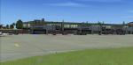
71.52Mb (1363 downloads)
Harrisburg International Airport (KMDT) Version 1.00 for FSX
Located in suburban Middletown, Pennsylvania (USA), the Harrisburg International Airport (KMDT) serves south-central Pennsylvania
and is the third-busiest airport in the state behind Philadelphia and Pittsburgh. Although air taxi and general aviation account
for nearly 75% of the traffic, MDT is also served by 5 airlines with daily or seasonal service to Florida, the legacy airline hubs
in the mid-atlantic and midwest, as well as air cargo carriers UPS and FedEx. By: Matthew Derr
Posted Oct 28, 2015 13:04 by uploader
87.15Mb (757 downloads)
FSX/Prepar3D Scenery - San Tome (SVST) - Venezuela
The San Tome Airport is located in San Tome, Anzoategui , Venezuela .
This airport serves the city of El Tigre, and San Jose which is 15 km from San Tome.
It reopened in 2005 with infrastructure improvements and the beaconing for night flights,
has a runway 1920m.
Photo-terrain area improved with Autogen files.
Only compatible with versions to FSX, P3Dv1.x or P3Dv2.x.
Also includes a friendly Auto-Install.
By David Maldonado - October 2015
Posted Oct 18, 2015 10:26 by David Maldonado