


1.25Mb (878 downloads)
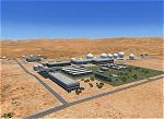
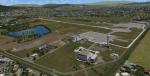
Joint Defense Facility Pine Gap is a satellite tracking station in the Australian outback operated by the United States intelligence community. The location is strategically significant because it controls United States spy satellites as they pass over the one third of the globe which includes China, the Asian parts of Russia and the Middle East. Central Australia was chosen because it was too remote for spy ships passing in international waters to intercept the signal. The facility has been described as the ground control and processing station for geosynchronous satellites engaged in signals intelligence collection. JDF Pine Gap is ran by the CIA, NSA, and NRO and is a key location in the global ECHELON surveillance network. Includes a helipad startup location with YPGP ident. Scenery by Jason L. Terry.
Posted Aug 16, 2014 00:51 by Jason L. Terry
40.94Mb (1500 downloads)
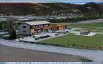
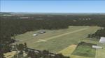
Kapfenberg Airport (German: Flugplatz Kapfenberg, ICAO: LOGK) is a public use airport located 3 kilometres (2 mi) east of Kapfenberg, Steiermark, Austria.
Posted Aug 14, 2014 10:07 by manfred marbler

1.45Mb (1610 downloads)
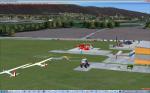
This is a rework of the default Vagar Airport which represents the airport close to its current state. Vagar Airport is the only airport in the Faroe Islands and is the home base of Atlantic Airways. Added gates and helipads, aprons and taxiways moved/adjusted to match aerial views, runway 13/31 extended to 1779 m / 5902 ft., turning circles added to the ends of Runway 13/31, control tower and fire station added, fuel truck added, runway lighting updated, airport views are from the roof of the control tower when in tower view. Made with the latest version of ADE (Airport Design Editor).
Posted Aug 13, 2014 14:10 by Joseph Friesen
28.29Mb (712 downloads)
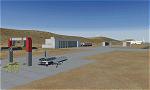
Australis is a joint private/military operations center located near Alice Springs in the Australian outback. It is the main base of operations of Aeroworks Technologies in the eastern hemisphere and conducts military missions in the far east of the globe. It acts very much the same as a normal AFB except that it is outside the US boundaries, and lies in a canyon very near the NSA Pine Gap facility. Occasionally some Russian and Chinese-built aircraft are trafficked through here. It also doubles as a spaceport and has shuttle recovery facilities similar to the ones in Railroad Valley. Scenery by Austin Gardner and Mike Vivaldi.
Posted Aug 13, 2014 01:18 by Austin Gardner
50.49Mb (1167 downloads)
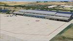
YUMA MCAS / YUMA International Airport,
Arizona, USA
KNYL (previous KYUM)
Version 1.0 for FSX/P3DV2
This Yuma Airport scenery was a side venture for a local expert on Yuma who got me interested in making the scenery for this airport. I agreed to this as a side project but it actually grew to become a medium detail level scenery project. I used mostly default elements for the aprons and taxiways and many other default objects. However, it still came out looking half decent. Shehryar 'Shez' Ansari/Brian Kircher
Posted Aug 11, 2014 06:21 by admin
46.39Mb (3653 downloads)
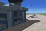
Airport is located in London,on a former Docklands site in the London Borough of Newham, some 6 NM (11 km - 6.9 mi) east of the City of London and a rather smaller distance east of Canary Wharf. These are the twin centres of London's financial industry, which is a major user of the airport. The airport was developed by the engineering company Mowlem in 1986-87.
London City Airport has a single 1,500-metre (4,900 ft) long runway.Only multi-engine, fixed-wing aircraft with special aircraft and aircrew certification to fly 5.5 degree approaches are allowed to conduct operations at London City Airport.
Posted Aug 11, 2014 04:11 by uploader

10.68Mb (4461 downloads)
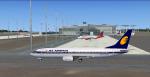
Rajiv Gandhi International Airport (VOHS), also known as Hyderabad International Airport, or simply RGIA, is an international airport serving the metropolis of Hyderabad located at Shamshabad, about 22 km (14 mi) south of Hyderaba, India.
It is named after former Prime Minister of India, Rajiv Gandhi. It replaced the former international airport at Begumpet and commercial flight operations began on 23 March 2008. Rajiv Gandhi International Airport is the second public-private partnership venture after Cochin International Airport. In 2010-11, it was the sixth busiest in India by international and overall passenger traffic.
The airport features as the top among Indian airports in the ranking of world airports for the year 2013 by Skytrax. It serves as a hub for SpiceJet, Lufthansa Cargo and Blue Dart Aviation and as a focus city for Air India, Jet Airways, and JetLite. See optional textures below which may be required.
Posted Aug 6, 2014 16:58 by Ratan Lewis
3.10Mb (690 downloads)
These texture files are needed if you see some dark(black)buildings at VOHS airport scenery (above). Since these are repeated texture files some of you may not need these files at all. To resolve the issue of dark building objects please move these BMP files to the texture folder of VOHS-AR619 scenery.
Posted Aug 6, 2014 16:36 by Ratan Lewis
15.44Mb (11737 downloads)
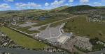
This is a scenery of Florence (Peretola) LIRQ airport for FSX. The scenery includes the photoreal area of the airport and surroundings area with a realistics autogen. The airport has been created faithfully and it has a correct position of the terminal with parking, hangars, static airplane, airport vehicles, trees and lights.
Posted Aug 6, 2014 10:55 by Matteo Veneziani
0.30Mb (539 downloads)
That freeware scenery for FSX represents the small, Tournus-Cuisery airfield (LFFX) in Burgundy, France, which is located between Chalon and Macon. Comes with a French readme too
Posted Aug 6, 2014 06:54 by G. Guichard