


0.01Mb (660 downloads)
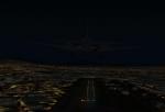
These are the mythical airports and the bombing range used in the FSDogfighter sessions. These airports are required to participate in the sessions. ORAI is Raider Airbase used by the Raider Squadron, OCRS is Crystal AFB used by the Ghost Squadron, and OBMB is the bombing range used by the Ghost Squadron, located a couple miles from OCRS.
Posted Feb 28, 2009 13:09 by Chris Beck
0.05Mb (1049 downloads)
Additions to Chile V.4. Includes new runway (San Geronimo, Olmue, Chicureo) and upgrade to others. This is an addition to the previous Chile V4, not a replacement.
Posted Feb 26, 2009 20:48 by Juan Lucero
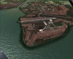
6.42Mb (2313 downloads)
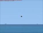
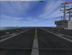
Ships spaced out to address a common frame rate complaint. Deleted choppers on decks(too much frame rate loss), deleted the oil platform.
Added another NDB, one for both carriers-Both on decks for ADF head wind approaches.
Carriers/Cruisers/Destroyers(Arrestor cables work), LOC/DME Carrier1 CAT II Ident IABC-RW 1 108.55 Mhz, Carrier2 CAT III Ident IABB-RW 2 108.10 Mhz. NO BACK COARSE,OR GLIDE SLOPE.
The airport name is KNKY_Carrier Miramar (KNKY) The NDB(none directional beacon) frequency is 235.0Khz for Carrier 1, and 455.0Khz for Carrier 2.
Range 100 NM. VOR-IDENT:MCG. Naval Fleet is 60 NM. west of Miramar MCAS.
You can't START on the Carriers, you'll end up in the water.
Posted Feb 26, 2009 14:08 by Thunder
9.70Mb (2269 downloads)
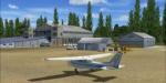
FSX PhotoReal scenery Szolnok-Szandaszollos Airport (LHSS). This little sport airport can be found in heart of Szolnok city, near the Tisza-river. Ideal for VFR flying, gliders and ultralight.
Bonus: Airport traffic and PhotoReal scenery Szolnok city v1.0 Created by Gabor Kovacs
Posted Feb 26, 2009 08:09 by Gábor Kovács
6.43Mb (6214 downloads)
Ships spaced out to address a common frame rate complaint, deleted choppers on decks (to much frame rate loss)
NDB, one for both carriers-Both on decks.
-Carriers/Cruisers/Destroyers. Arrestor cables work. LOC/DME Carrier1-R1 108.95Mhz Ident IABA Cat II, Carrier2-R2 109.30Mhz Ident IABB Cat III, NO BACK COARSE OR GLIDE SLOPE.
The airport name is FSXF-Carrier Oceana.(KNTC) The NDB(none directional beacon) frequency is 401.0Khz Carrier-1, 534.0Khz Carrier-2, range 100 NM. VOR-IDENT:OCG.
Naval Fleet is 12 NM. North-East of Oceana NAS.
You can't spawn on the decks of the Carriers, you'll end up in the water! Please read the 'Readme'!
Posted Feb 25, 2009 18:49 by Thunder
8.57Mb (3050 downloads)
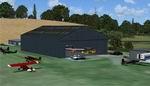
FSX Alf's UK Airfields Volume 15. Upgrades many small UK airfields whose default versions have little or no detail. Based on Google Earth and airport guides. This volume includes Eggesford X2EG, Eshott EG18, Swansea EGFH. By Alf Denham.
Posted Feb 25, 2009 04:54 by Alf Denham
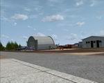
0.11Mb (4660 downloads)
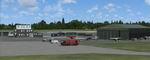
FSX McDill AFB (KMCF), Tampa, Florida (FL). Taxiways and aprons have been relocated according to Google Earth, and some buildings have been changed, taxiway designations corrected, parking added, connecting roads added, landclass and boundary fences around the airfield changed and some library objects placed (including B52s on the ramp). By Art Poole.
Posted Feb 25, 2009 03:29 by Art Poole
23.12Mb (1169 downloads)
FSX Louisville PhotoReal Scenery Section P Update
This contains a missing file from the high resolution, 1Meter/Pixel, terrain scenery for Louisville, Ky, section, P, which features the Floyd Knobs West of Rubber Town. Please add this file following a previous install of LouX1MP.
By Jim Jones.
Required files:
required file
Posted Feb 19, 2009 16:06 by Jim Jones
0.02Mb (1093 downloads)
Upgrade Chile V.4 It includes new runway and upgrade to others (SCUN, SCVK. SCTL).It solves problem caused by SHLP in SCTB.
Posted Feb 17, 2009 21:55 by Juan Lucero
26.61Mb (2962 downloads)
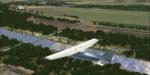
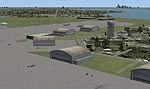
Istanbul Hezarfen Airfield LTBW Scenery.
A detailed re-creation of the Istanbul Hezarfen airfield and surroundings, for FSX (SP2).
Hezarfen Airfiled is the main light GA airfield of Istanbul and is a nice start location VRF flights and flight lessons.
This is a detailed scenery and it has 50cm resolution photoreal texture components, so you have to adjust your scenery and autogen settings to at least DENSE , and texture resolution settings to 30cm (or 7cm) to see the scenery in full detail. Sunay KILIC
Posted Feb 16, 2009 13:16 by Sunay KILIC