


26.83Mb (481 downloads)
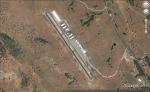
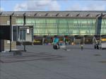
Calaveras County Airport (ICAO: KCPU) also known as Maury Rasmussen Field, is a public airport located four miles (6 km) southeast of the central business district of San Andreas, in Calaveras County, California, United States. It is owned by the County of Calaveras. For the 12-month period ending September 21, 2005, the airport had 25,000 aircraft operations, an average of 68 per day, all of which were general aviation.
A great airport to depart from for some mountain flying as it is located not far from the sierra Nevada Mountains. I noticed there was no scenery for this airport so I fixed that. Airport includes custom lights and a animated hanger. full details in the readme.
Scenery by CountryFlyboy. be shur to visit me on Youtube for weekly Flight Simulation News and videos
Posted Oct 14, 2014 01:35 by CountryFlyboy
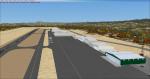
6.72Mb (1796 downloads)
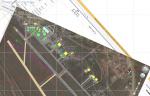
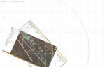
Airfield of Belluno (LIDB) and dam of Vajont in Italy.
Posted Oct 11, 2014 12:30 by Voyager
11.45Mb (1099 downloads)
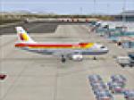
Fixed: These textures are for the FAIB FSX version of the A319 CFM. They are the complete Iberia A319 fleet as of 2014. The base file can be found on http://fsxaibureau.com/manufacturing/. Please make sure it is the FSX model not the FS9 model you are using. All textures are in .dds format please read the READ ME file for installation. Look out for the A320 and A321 Iberia fleets soon.
Base
Package (external link. Please
report if broken)
Posted Oct 6, 2014 01:17 by Nick Fionnlagh
0.82Mb (946 downloads)
RJFU Nagasaki, Japan, is an Adex based compilation of Nagasaki Airport, Omura City, Nagasaki Pref.
Posted Oct 5, 2014 21:52 by Sergey Stoyanov
2.47Mb (1311 downloads)
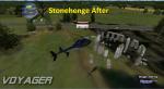
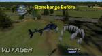
Updated Stonehenge scenery in the UK. Adds more monuments to the default scenery.
Posted Oct 4, 2014 02:01 by Voyager
7.48Mb (2962 downloads)
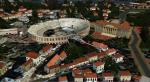
FSX Verona scenery. Verona Arena is a Roman amphitheatre in Piazza Bra in Verona, Italy. Added the Verona arena and Palace Barbieri.
To make it easier to locate the buildings in the scenery I included
2 hot air balloons stationed in the sky above.
Posted Oct 4, 2014 01:51 by Voyager
23.74Mb (1394 downloads)
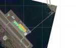
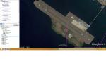
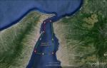
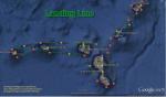
This scenenery is a simulation of naval and tourist traffic
in the Strait of Messina (Italy/Sicily/Messina). In addition
other 2 routes of the USS NIMITZ.
The first route of the USS NIMITZ is limited in the Straits of Messina
while the second path sees the USS NIMITZ around the Aeolian Islands.
For a complete overview or mapping of the paths mentioned above are
included in this package and the related photo file for Google Earth.
Posted Oct 4, 2014 00:19 by Voyager
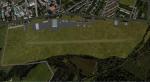
40.37Mb (1927 downloads)
ROAH Okonawa Airport is one of the aerodromes situated on Okinawa island, Japan. Installation as usual. Project work evaluation is into added directory.
Posted Oct 3, 2014 20:53 by Sergey Stoyanov
84.75Mb (3730 downloads)
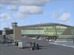
Armando Tola-El Calafate International Airport, Argentina. Animated people and vehicles. Summer and Winter versions.
Posted Oct 2, 2014 11:18 by SIMARG Simulacion Argentina
11.95Mb (1303 downloads)
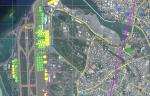
UlaanBaatar Int.(ZMUB)is the biggest airport of Mongolia. The presented package has a goal to improve the FSX ZMUB to the real arport, as close that could have been done. Installation as usual. Work directory also added.
Posted Oct 2, 2014 00:09 by Sergey Stoyanov