


6.46Mb (221 downloads)
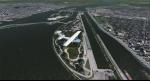
FSX Jayapura WAJJ, Indonesia. Dortheys Hiyo Eluay International Airport, formerly known as Sentani International Airport is an airport serving Jayapura, the capital of Papua province, Indonesia, on the island of New Guinea. By Ahmad Hamil
Posted Jun 24, 2021 04:38 by uploader
18.05Mb (435 downloads)
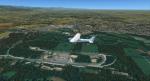
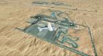
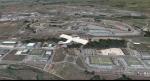
Photorealistic scenery for FSX (should work on P3D V 1-4). Overlapping edges from photo into default scenery. Enhanced airport close to real with custom buildings and some static objects. Day and Night textures. Some autogen at airport, circuit and surrounding areas. FTX Global and Vector compatible.
Posted Jun 21, 2021 02:02 by Ignacio Del Muro
2.59Mb (215 downloads)
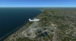
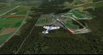
Photorealistic scenery for FSX (should work on P3D V 1-4). Overlapping edges from photo into default scenery. Enhanced airport close to real with custom buildings and some static objects. Day and Night textures. Some autogen at airport, circuit and surrounding areas. FTX Global and Vector compatible.
Posted Jun 21, 2021 01:58 by Ignacio Del Muro
16.70Mb (234 downloads)
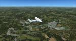
Photorealistic scenery for FSX (should work on P3D V 1-4). Overlapping edges from photo into default scenery. Enhanced airport close to real with custom buildings and some static objects. Day and Night textures. Some autogen at airport, circuit and surrounding areas. FTX Global and Vector compatible.
Posted Jun 21, 2021 01:58 by Ignacio Del Muro
17.08Mb (166 downloads)
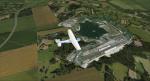
Photorealistic scenery for FSX (should work on P3D V 1-4). Overlapping edges from photo into default scenery. Enhanced airport close to real with custom buildings and some static objects. Day and Night textures. Some autogen at airport, circuit and surrounding areas. FTX Global and Vector compatible.
Posted Jun 20, 2021 02:42 by Ignacio Del Muro
56.19Mb (312 downloads)
Photorealistic scenery for FSX (should work on P3D V 1-4). Overlapping edges from photo into default scenery. Enhanced airport close to real with custom buildings and some static objects. Day and Night textures. Some autogen at airport, circuit and surrounding areas. FTX Global and Vector compatible.
Posted Jun 19, 2021 05:58 by Ignacio Del Muro
10.66Mb (222 downloads)
Photorealistic scenery for FSX (should work on P3D V 1-4). Overlapping edges from photo into default scenery. Enhanced airport close to real with custom buildings and some static objects. Day and Night textures. Some autogen at airport, circuit and surrounding areas. FTX Global and Vector compatible.
Posted Jun 19, 2021 05:46 by Ignacio Del Muro
4.28Mb (565 downloads)
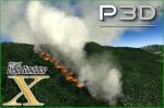
This scenario contains seven forest fires located not far from the city of Monterrey in Mexico.
It has fire and smoke effects that are visible from a great distance during the day and at night, some of these fires have been placed in real locations where there have been large fires and are now available to simulate in fsx and p3d.
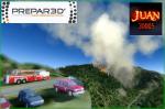
-install on P3D: copy the scenario files to: -> Prepar3D vX\Addon Scenery\scenery. (FSX style if you don't have these folders you can create them so adding scenarios is easier. using the "SceneryConfigEditor" program you add it to the prepar3d library) look the images p3d-add 1 and p3d-add 2. Or you can add these scenery files to your favorite add-on folders.
more info install scenery p3d: https://www.prepar3d.com/SDKv4/prepar3d/world/scenery_library/scenery_library_overview.html
-install on FSX: copy the scenario files to: -> Microsoft Flight Simulator X\Addon Scenery\scenery
(I recommend having vector data for so this emergency vehicles are parked on the side of these roads. You can also download the terrain mesh since the default data is of low quality)
Posted Jun 19, 2021 03:04 by juan30005
259.32Mb (269 downloads)
Photorealistic scenery for FSX (should work on P3D V 1-4). Overlapping edges from photo into default scenery. Enhanced airport close to real with custom buildings and some static objects. Day and Night textures. Some autogen at airport, circuit and surrounding areas. FTX Global and Vector compatible.
Posted Jun 16, 2021 06:15 by Ignacio Del Muro
21.85Mb (287 downloads)
Photorealistic scenery for FSX (should work on P3D V 1-4). Overlapping edges from photo into default scenery. Enhanced airport close to real with custom buildings and some static objects. Day and Night textures. Some autogen at airport, circuit and surrounding areas. FTX Global and Vector compatible.
Posted Jun 16, 2021 05:38 by Ignacio Del Muro