


FS2002 > Page 376
0.03Mb (795 downloads)
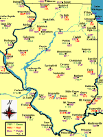
Illinois
Navigation Aids Ver. 1.0 Illinois Navigation Aids was
made with Paint Shop Pro. This is the third state map created.
New York and Florida are also available. The Cities on the map
are Navigation Points, but most of them have airports as well.
Created by Bob Baker. 28K
Posted Jun 23, 2008 14:31 by archive
0.02Mb (1159 downloads)
Boeing
767 & 777 Fuel Calculator - The Excel spreadsheet
is used to calulate optimal flightlevel , needed fuel,flight-time
and takeoff/landing weights for B767 and B777 in simulator use.
This is provided as it is with no warranty or guarantee and
no responsibility for possible damage it could cause. Can be
used, modificated and distributed without charge. It is not
to be included with any commercial product or CD-rom. Have fun
Olof Niklander . File size 18k
Posted Jun 23, 2008 14:31 by archive
0.55Mb (1948 downloads)
Database
for above with 50000 navaids & more. File size 580518
World
UK Map for use with this program & Nav 1.8. V.2.00.
Full UK map. File size 1196343
Posted Jun 23, 2008 14:31 by archive
5.91Mb (4224 downloads)
Super
Flight Planner 2.8.0 Full Package. Advanced freeware
Flight Planner, Moving Map, Scenery Viewer and Adventure Maker
for FS95-FS98-FS2000-FS2002. Can create adventures using its
own engine or, if you have it, for Radar Contact. Can export
and import data to/from a lot of GPS's, Moving Maps and so on.
By Alessandro Antonini, "theflyguy". 6MB.
Posted Jun 23, 2008 14:31 by archive
0.01Mb (937 downloads)
US
Airports List. Most US airports listed giving ATIS,
VOR's, listed by state. File size 8k. E Steinsto
Posted Jun 23, 2008 14:31 by archive
0.02Mb (770 downloads)
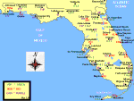
Florida
Navigation Aids Ver. 1.0 Florida Navigation Aids was
made with Paint Shop Pro. Rotate the map 90 degrees to print
the full size map. The Cities on the map are Navigation Points,
but most of them have airports as well. Created by Bob Baker.
23K
Posted Jun 23, 2008 14:31 by archive
0.03Mb (905 downloads)
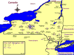
New
York Navaids Map - showing elevations, VOR's & NDB's.
File size 66269. Bob Baker
Posted Jun 23, 2008 14:31 by archive
0.14Mb (1019 downloads)
Flight
Data Recorder saves your aircraft's flight data to a
file as you fly. After your flight, you can analyze the flight
data file to see how well you performed. File size 141780. A
Azofran, German Pardo H
Posted Jun 23, 2008 14:31 by archive
0.09Mb (1658 downloads)
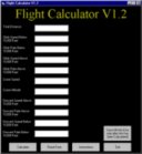
Flight
Calculator V1.2 This is a Visual Basic conversion of
my old BASIC program, ETA Utilily, and Flight Calculator. Features
are saving the information that was calculated and Climb Speed
above and below 10,000 feet as well as climb rate above and
below 10,000 feet allowing for better time calculation. Also
finds your Total Time, Cruise Time, and the distance out you
should start descending. By Shane Johnson. 90K
Posted Jun 23, 2008 14:31 by archive
0.40Mb (1184 downloads)
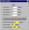
Wind
Correction Angle calculator. File size 415K. K Schroijen
Posted Jun 23, 2008 14:31 by archive