


FS2002 > Page 381
0.03Mb (165 downloads)
FS2002
Lakefront to Baton Rouge Second in a series of GA AI
flight plans for the USA. This is between Lakefront (KNEW) and
Baton Rouge (KBTR). Please use the readme file as instuctions
for use. Remember! Eye candy is good! If you can think of a
couple of airports that can use some traffic, just get ahold
of me. For use with the latest version of TrafficTools for FS2002
by Lee Swordy. By Steve Burnett. 34K
Posted Jun 23, 2008 14:31 by archive
0.00Mb (324 downloads)
FS2002
"MEXICANA AI FLIGHT PLANS" by Luis Nieto Gama. 6K
Posted Jun 23, 2008 14:31 by archive
0.12Mb (593 downloads)
FS2002
Scenic Tour Of The World Flightplans VFR These 44 Flightplans
Will Take You To All The Main Areas Of Scenery In The FS2002
World. Starting And Finishing At Manchester U.K You Can Use
Whatever Aircraft You Like. Varys From Short To Long Haul Journeys
VFR Version . IFR Version Available. 121K IFR
Version Available.117K
Posted Jun 23, 2008 14:31 by archive
0.01Mb (294 downloads)
distance
calculator 1.0 This ms-dos program converts kilometers
to miles and miles to kilometers. I made it very easy to use.
Look for a program that im working on now that will convert
altitude between metric and imperial measurments. By:Mike Suitts.
13K
Posted Jun 23, 2008 14:31 by archive
0.70Mb (256 downloads)
FSFailure,
v1.1.0 SIGNIFICANT CHANGES SINCE v1.0.0 (see README)
Tested on FS2K, should work on any simulator supported by Peter
Dowson's FSUIPC (v1.94 or higher). Fixes FS2K's pre-planned
failures by creating random system, radio, engine, and instrument
failures based on probability settings. By Jim Schein. 716K
Posted Jun 23, 2008 14:31 by archive
0.28Mb (543 downloads)
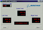
Fuel
Calculator for B737-400. Not related to any Sim. Can
be used for any purpose. Author: Peter J. Faase. 288K
Posted Jun 23, 2008 14:31 by archive
0.04Mb (302 downloads)
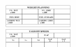
Flight
Planning Form JetplanThis is a planning form I developed
to assist in flight planning for the 737 and 757 in FLY. It
can be used with all flight simulation software. This form is
public domain. This file is intended for flight simulation only,
do not use for real flight planning. Have a nice day. Jim Donlin.
40K
Posted Jun 23, 2008 14:31 by archive
0.22Mb (747 downloads)
UK
Landing charts in PDF format. (Acrobat) Includes EGGP/
Liverpool; EGLC/ London - City; EGLL/ London - Heathrow; EGPO/
Stornoway; EGSS/ London - Stansted;. By Bertil Gullmar TEAM
FSS. 221K
Posted Jun 23, 2008 14:31 by archive
0.70Mb (312 downloads)
Kingair
Kneeboards scanned by :chris jurczyk includes: -IFR
kneeboard -VFR kneeboard **COURTESY OF KING SCHOOLS, INC. 717K
Posted Jun 23, 2008 14:31 by archive
0.15Mb (546 downloads)
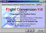
FLiCK
v1 - Flight Conversion Kit A small Utility I wrote
to convert airspeed, fuel consumption, distance, Bank angles,
Descent rates, just about everything. Bu Stephen Davey 158K
Posted Jun 23, 2008 14:31 by archive