


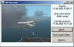
0.77Mb (1721 downloads)
YAFSScreen
is a rewrite of Matthias Holzers great FSScreen-Program - It
can save a single image (or other data that has been copied
to the clipboard) in multiple copies to several directories.
- It does not remove the data from the clipboard as FSScreen
appears to do. So you can still paste into another program and
non-standard copy/paste operations as in MS Excel continue to
work even if YAFSScreen is running. - When saving images you
can select from (as of now) three formats. BMP, GIF and JPEG,
selecting special options where applicable. - Images can be
scaled in various ways before being saved. I use this to save
a thumbnail and a full-size-image from every screenshot. - After
saving a file YAFSScreen can run any program on it. - It opens
explorer on the target folder at the press of a button to allow
browsing. - It has a longer name. In a great tradition I have
called it "Yet Another FSScreen". 786K
Posted Jun 23, 2008 14:31 by archive
0.58Mb (1587 downloads)
FS2002
Weather : How to have a good real weather program in
FS2002 with the ATC function enabled. This combination of programs
offrs the possibility to have the most missing tool in FS2002:
a good weather program and have FS2002 as real as possible.
This is version 3 of this weather program. by Jerry Joseph.
596K
Posted Jun 23, 2008 14:31 by archive
0.00Mb (2846 downloads)
FS2002
Cabin Lighting Tutorial: This addition can make your
panels look more even-lighted by casting an even amber floodlight
on the panel and or no light on the panel, and soft-white inside
the instruments.By Alex Yanes. 2K
Posted Jun 23, 2008 14:31 by archive
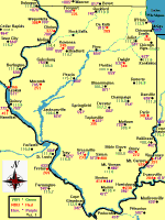
0.03Mb (795 downloads)
Illinois
Navigation Aids Ver. 1.0 Illinois Navigation Aids was
made with Paint Shop Pro. This is the third state map created.
New York and Florida are also available. The Cities on the map
are Navigation Points, but most of them have airports as well.
Created by Bob Baker. 28K
Posted Jun 23, 2008 14:31 by archive
0.02Mb (1159 downloads)
Boeing
767 & 777 Fuel Calculator - The Excel spreadsheet
is used to calulate optimal flightlevel , needed fuel,flight-time
and takeoff/landing weights for B767 and B777 in simulator use.
This is provided as it is with no warranty or guarantee and
no responsibility for possible damage it could cause. Can be
used, modificated and distributed without charge. It is not
to be included with any commercial product or CD-rom. Have fun
Olof Niklander . File size 18k
Posted Jun 23, 2008 14:31 by archive
0.55Mb (1948 downloads)
Database
for above with 50000 navaids & more. File size 580518
World
UK Map for use with this program & Nav 1.8. V.2.00.
Full UK map. File size 1196343
Posted Jun 23, 2008 14:31 by archive
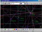
5.91Mb (4224 downloads)
Super
Flight Planner 2.8.0 Full Package. Advanced freeware
Flight Planner, Moving Map, Scenery Viewer and Adventure Maker
for FS95-FS98-FS2000-FS2002. Can create adventures using its
own engine or, if you have it, for Radar Contact. Can export
and import data to/from a lot of GPS's, Moving Maps and so on.
By Alessandro Antonini, "theflyguy". 6MB.
Posted Jun 23, 2008 14:31 by archive
0.01Mb (937 downloads)
US
Airports List. Most US airports listed giving ATIS,
VOR's, listed by state. File size 8k. E Steinsto
Posted Jun 23, 2008 14:31 by archive
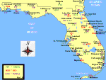
0.02Mb (770 downloads)
Florida
Navigation Aids Ver. 1.0 Florida Navigation Aids was
made with Paint Shop Pro. Rotate the map 90 degrees to print
the full size map. The Cities on the map are Navigation Points,
but most of them have airports as well. Created by Bob Baker.
23K
Posted Jun 23, 2008 14:31 by archive
0.03Mb (905 downloads)
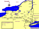
New
York Navaids Map - showing elevations, VOR's & NDB's.
File size 66269. Bob Baker
Posted Jun 23, 2008 14:31 by archive