


FS2004 > Page 1344
10.36Mb (1539 downloads)
FS2004
Jamaica 38.2 m Terrain Mesh.
Covers the whole of Jamaica - with a reworked and much improved
srtm based terrain mesh - enahnced resolutions details reworked
the original srtm tiles with additional elevation points - and
recompiled at Lod 10 38.2 m with terrain. Raimondo Taburet.
10.6MB
Posted Jun 23, 2008 14:24 by archive
0.19Mb (3267 downloads)
FS2004
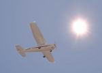
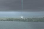
Sun Mod V.2.
The fact that you're reading this means you have downloaded
the new and improved Sunmod V2. The biggest change from Sunmod
to Sunmod V2 is the fact that I have decided to drop the version
with a lensflare. The main reason for this is that the primary
objective of this new version was to create a brighter more
realistic sun for FS, and FS didn't display this very well and
basically I was forced to drop the Lensflare version. And on
the other hand how many times have you seen a lensflare looking
at the sun directly instead of using photo or videocameras?
198K
Posted Jun 23, 2008 14:24 by archive
0.30Mb (2313 downloads)
FS2004
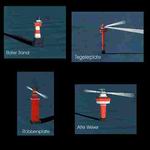
Scenery with 4 Lighthouses
at the Weser Entry into the North sea. Lighthouses: Alte Weser,
Roter Sand, Robbenplate and Tegelerplate. Created by Frank Lücke
as a surplus to the Bremerhaven (EDWB) sceneries. 304K
Posted Jun 23, 2008 14:24 by archive
1.38Mb (1585 downloads)
FS2004
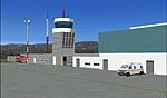
Santa Rosa de Conlara International Airport, Argentina
( SAOS ).It is the airport of Villa de Merlo resort town , located
in San Luis Province .Built in a valley surrounded by mountains.
it is a completely new airport , opened in 2001 and despite
its size and traffic it has a telescopic passenger bridge.New
AFCAD2 and new Landclass.By Jorge Pagano. 1.4MB
Posted Jun 23, 2008 14:24 by archive
0.33Mb (1912 downloads)
FS2004
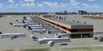
Portland International Airport, Portland. Or.
This scenery is a complete makeover for the default Portland
International airport in Portland. Rojeet Singh. 337K
Posted Jun 23, 2008 14:24 by archive
0.43Mb (2086 downloads)
FS2004
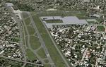
Detroit City Airport (KDET) Scenery.
Scenery for Coleman A. Young Municipal (KDET) airport in Detroit,
Michigan. Includes AFCAD 2 file and landclass. By Mike Magner.
443K
Posted Jun 23, 2008 14:24 by archive
0.80Mb (3360 downloads)
FS2004
Atlanta Scenery - 2005
This is a set up for KATL using Rwy12 Scenery Creator. Rwy12
Object Placer required (here).
If you don't have it, then you won't see anything, because all
the scenery files come from having Rwy 12 installed on your
computer. .By: Adam J. Sereika. 820K
Required files:
required file
Posted Jun 23, 2008 14:24 by archive
0.00Mb (1190 downloads)
FS2004
RAF Wittering, UK, AFCAD file.
RAF wittering is a little airfield, laid in the east midlands,
this file will update the airfield so it has neccersary parking
spaces and taxiways/scenery. 3K
Posted Jun 23, 2008 14:24 by archive
6.76Mb (2496 downloads)
FS2004/2002
Tornado..This is the Land version. A flyable & moveable
tornado - it includes debree flying..and lightning flash at
your will-by pressing the I key..For best realistic effect..you
will need the active camera program.. which produces a flyby
of the tornado you wont forget...by Ron Jeffers. 6.9MB
Posted Jun 23, 2008 14:24 by archive
6.74Mb (3478 downloads)
FS2004
Waterspout.
The weather is heating up and getting a bit nasty..ever wish
you could do something about it? Now you can..A flyable &
moveable waterspout - Fly a waterspout/tornado in FS9 and make
it go where (you) want it to go..watch your weather vortex blow
up water on the sea and then transform blowing up dirt as it
hits land..take it downtown in your favorite city and proove
the FS weatherman wrong..a flight scenario is included and weather
instructions for best effect in FS9.. By-Ron Jeffers. 6.9MB
Posted Jun 23, 2008 14:24 by archive