


FS2004 > Page 1354
1.46Mb (1439 downloads)
FS2004
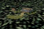
Vancouver International Airport-CYVR42v+ Upgrade to make CYVR42
compatible with Vancouver+
(payware scenery by Patch and Sandmann). Must have CYVR42 (here)
installed (with or without fps fix) By P Nigel Grant, Vancouver.
1.5MB
Posted Jun 23, 2008 14:24 by archive
0.89Mb (3918 downloads)
FS2004
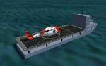
The Navy Helo landing trainer(HLT). The
HLT is located in Mobile Al, Bay near KBFM airport. Turn to
heading 133 from KBFM and you should run across it. Phil Floyd.
913K
Posted Jun 23, 2008 14:24 by archive
64.19Mb (7684 downloads)
FS2004
Spanish "Los LLanos Air Base" (LEAB) Scenery Package,
about 100KM2 of a good photo real area around LEAB Air Base.
Enjoy and fly like a Mirage F1M Spanish pilot. LeAB Scenery
is a v1.2005 beta version we will working in a new best and
full version. By Manuel Marin Carrion. 65.7MB
Posted Jun 23, 2008 14:24 by archive
0.77Mb (3475 downloads)
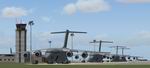
FS2004
Incirlik Air Base near Adana, Turkey.
Incirlik is currently home to the 39th Air Base Wing which hosts
deployed aicraft in support of world-wide operations. The base
has been involved in Operations Northern Watch, Enduring Freedom,
and Iraqi Freedom and has seen a recent increase in the number
of airlift sorties due to the closing of Rhein-Main Air Base.
Created using an official U.S. Air Force diagram and Ian McCartney's
excelent HAS models. Includes AFCAD with parking for 57 fighter
aircraft. By Matt Magner. 792K
Posted Jun 23, 2008 14:24 by archive
12.60Mb (8419 downloads)
FS2004
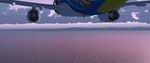
New Water Effects.
This is my first offering to the FS World. It's a new set of
water textures that really enhance the water world. After considerable
mixing and matching, I stumbled upon this mix. I find it greatly
enhances the FS Water. I have included 2 screenshots of the
results in case anyone wants to know what the water looks like.
Be warned though, your taste may differ from mine so always
make a backup of your files before modifying anything. I take
no credit whatsoever of these files. Original credit goes to
Chrisitan H. Halden and Kevin Rangel. A big word of thanks to
both. I have in no way modified or updated any of their works.
Just a simple game of mix and match. Ashar Khan. 12.9MB
Posted Jun 23, 2008 14:24 by archive
2.01Mb (784 downloads)
FS2004
Fictional Tropical Island.
Situated in the middle of the Carribean. Gareth Scott. 2MB
Posted Jun 23, 2008 14:24 by archive
4.51Mb (5564 downloads)
FS2004
SOCA Rochambeau, International Airport of French Guyana.
"ROCHAMBEAU"
is a detailed scenery of the International Airport of French
Guyana. This scenery has been created under the ask of Wilfrid
who had given to me all of photos and documentations about this
airport, thank to him and his freinds of Guyana for theire airport
wiews. Thank to Joël Lemki, webmaster of:( http://fsguyane.info/
) for his help and his participation for textures release about
Rochambeau airport and his great work in the developpement of
Guyana sceneries for FS. Great thank to Yannick Mille, webmaster
of:( www.fsfrance.com) for using ground vehicles textures of
his beautifull Roissy Charles de Gaulle airport scenery release:"RealCDG".
Delblond Christian. 4.6MB
Posted Jun 23, 2008 14:24 by archive
1.71Mb (2337 downloads)
FS2002/2004
Kourou Space Center French Guiana.
The European spaceport in French Guyana. You can explore the
pads and the ESA facilities : the ELA 1, 2 and 3 pads and others
majors infrastructures. And if You flight around ELA 1, you
can look a future Vega laucher on the pad. Inclued, the Port
of the Degrades, the city of Kourou, the local road network
and the Kourou little airfield. Scenery by Gaël LE BRIS - Distributed
by COGITO. 1.7MB
Posted Jun 23, 2008 14:24 by archive
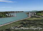
1.66Mb (1935 downloads)
FS2004
The Menai Suspension Bridge Project - between North Wales &
Anglesey in UK.
Menai Suspension Bridge scenery for flight simulator 2004 by
Dyl Roberts. 1.7MB
Posted Jun 23, 2008 14:24 by archive
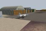
9.50Mb (1477 downloads)
FS2004
"Colorado Hops".
For helicopter lovers. In this scenery you will find several
spots around Denver, CO. Updated Jeffco airport ("Rotors of
the Rockies" hangars, new control tower, new main building,
Fire station, McCair building, R22 School...), helipads in some
airports in the near area, S&R Base, "The Fort", "Manor House",
Mountain Resort, Swedish Medical Center, North Suburban Medical
Center, St Anthony North Hospital...by LBMartin. 9.7MB
Posted Jun 23, 2008 14:24 by archive