


42.78Mb (585 downloads)
More than 3500 downloads on Flightsim.to (file withdrawn)
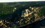
A lot of castles on the edge of Dordogne, because it was the frontier brtween France and England during the 100 years war ....
Posted Feb 23, 2023 08:42 by Laudey1
144.10Mb (497 downloads)
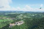
Already more than 3000 downloads on Flightsim.to(File withdrawn).
All the castles and most known POIs are part of this scenery, to improve the basic content of MSFS.
Posted Feb 23, 2023 08:24 by Laudey1
0.09Mb (190 downloads)
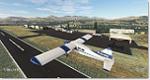
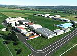
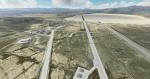
This package contains six airports in the Okanogan Valley, WA State. From Monse to the Canadian border. All runways, taxiways, aprons and parking redone and objects hand placed. Biomes changed to reflect the orchards in many areas. All airports are starred, but they are South to North: MA01 Monse (Ag), S35 Okanogan Legion, WT37 Lockwood Dry Coulee (Ag), KOMK Omak Muni, W01 Tonasket Muni and 0S7 Dorothy Scott International.
There are two object libraries that these files are dependent on:
Emerald Object Library: https://emeraldscenerydesign.com/products/eolib-msfs/
CBJlib: https://flightsim.to/file/16007/msfs-object-library-with-150-models-ranging-from-towers-hangers-terminals-to-cones (may need to make an account at "flight.to" for this one but these objects are common across many freeware sceneries)
And a third (optional) library if you want animated people at some of the airports:
https://flightsim.to/file/33166/animated-humans-library
Unzip the file, open it and place the six individual airport files in your community folder.
Download the object libraries and place them in your Community folder also. Enjoy!
Posted Jan 4, 2023 01:07 by Chuck79

2251.33Mb (1680 downloads)
This is Version 3.0 of the Global AI Ship Traffic Ultra. More than 400 new ships have been added since last version bringing the number of unique ship models close to 900 and the number of ships including repaints close to 1800. The route coverage has been expanded increasing traffic density though focus is as usual to have a diverse ship traffic according to what you could see in each region. To reduce load on computer systems, the ship routes have in this version been included as separate regional packages, so you only need to install the routes in the area where you intend to fly. Models and textures by Erwin Welker, Jean-Pierre Fillion, Knud Kristoffersen, Martin Rueedi, Larry Robinson, Dexter, Milton Shupe, Manfred Siedler, Bernardo Barroso, Paul Donnelly, Finn Kristoffer, Didier ‘‘Lagaffe’’ Puentes, Andrew Thomsen, Kevair, Robystar, Antonio Diaz, Sebastien Viale, Alberto Garcia, Cxema, Pascal Dumat, Rick Keller, Lazarus Starkweather, Dave Garwood, Darren Lane, Jan de Jong, Henrik Nielsen, and more
Posted Dec 30, 2022 16:49 by Henrik Nielsen
287.84Mb (143 downloads)
This is an complete rebuild of the Pallamana Airport which Runway 19 has just been bitumised and is a s close as it gets to the actual airport.
By Roger Leupold
Posted Dec 14, 2022 04:30 by Roger Leupold
25.43Mb (137 downloads)
This is an up to date and adaptation to MSFS of fsx lfpa scenery by Benoit Gaurant and Dan Guimbert.
Posted Dec 7, 2022 01:09 by Benoit Gaurant
1401.47Mb (286 downloads)
MSFS2020 - EGKK Gatwick Airport Scenery, England V.10.8.11 [4K].
Magvar changed to 0.5 degrees East for ILS localiser line up.
Continuation of taxiway lines.
Parking Centre lines.
Custom IRL Taxiway signage.
Posted Sep 22, 2022 05:40 by Quasimodem
0.06Mb (402 downloads)
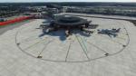
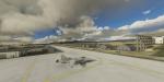
Area 51 - also known as Homey Airport KXTA - is a pretty mysterious place. Whether you’re a skeptic, “want to believe”, or are a fervent believer in the extraterrestrial related activities of Area 5, it is no doubt a pretty cool place to go visit in Microsoft Flight Simulator. I definitely think it’s preferable to Naruto running full force at the place in real life… but that’s just a personal preference I guess. The main addition here relates to the lighting of the buildings at night, and the addition of a variety of buildings which add a more authentic and militaristic feel to the place. Created by Richard-DHI
Posted Apr 22, 2022 06:26 by mrflyer
39.77Mb (1727 downloads)
Background
Microsoft Flight Simulator 2020 uses Bing's satellite map. However, the satellite map is relatively old, and many areas are not directly equipped with map settings a few years ago. This phenomenon occurs in different regions of the world. The map on the mainland is even 10 years ago. There are a large number of regions where satellite images are not available. Microsoft uses the program-generated map instead, and the quality is very poor. After the replacement, the image quality and details have been significantly improved, as shown in the figure below
History and related information
I have been studying the possibility of replacing it with Google Maps for a long time, and there are also YouTubers on the Internet who have provided [some ideas](https://flightsim.to/file/4074/google-earth-decoder-optimisation-tools?__cf_chl_jschl_tk__= pmd_2902fb008a3441de2f812b093625596ad796f737-1628304162-0-gqNtZGzNAk2jcnBszQjO), use a crawler to crawl the data from Google and import it into MSFS2020. But this method is more complicated and cannot be used on a large scale.
Full instructions included
Posted Nov 13, 2021 06:15 by uploader
197.54Mb (163 downloads)
Oxford version one . Buildings a little bluish tinge I will work on this for the next version
Posted May 1, 2021 05:06 by mrbump