


FSX > Page 1083
9.57Mb (226 downloads)
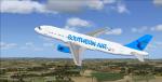
Project Airbus A320-200 in the colors of Southern Air (fictional airline) textures only for the Project Airbus A320-200. 'Southern Air' operates in South Africa between Cape Horn International & Overberg Air Force base near Cape Agulhas (Africa's southernmost tip). Coupled to the default A321 VC. Repaint of the great Project Airbus v2 A-320 by Jacques Louw. Assembled for FSX by Chris Evans.
Posted Aug 12, 2013 02:32 by Jacques Louw
7.32Mb (228 downloads)
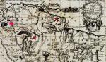
Elk City airport (S90) photoreal scenery with custom objects. Made to blend with ORBX NRM (will not blend with default FSX). Comes with seasonal and night textures. Please see "Readme" file for more instructions.
Posted Aug 11, 2013 22:17 by Brett Lee
66.86Mb (7797 downloads)
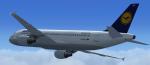
Project Airbus.
Two A320 Lufthansa D-AIQW, new and old, for FSX.
Includes default VC with upgraded textures by Jim Fly.
You can find this aircraft under
'Project Airbus' in your FSX menu.
Repaint by Jim Fly
Posted Aug 11, 2013 07:13 by Jim Fly
11.29Mb (939 downloads)
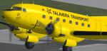
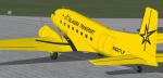
FSX Douglas C-117D repaint textures for Phoenix based Talavera Transport N637LF,
for the freeware Manfred Jahn and team Douglas C-117D (c117d_v1_beta.zip),
which you must have previously installed in FSX. Also includes engine exhaust
smoke coordinates which you can add to your "aircraft.cfg" if you wish.
Screenshots enclosed. Easy installation. Repaint by Tom Tiedman.
Required files:
required file
Posted Aug 11, 2013 03:42 by Tom Tiedman
2.17Mb (1666 downloads)
This is your first assignment with Idaho Air Service. IAS is a charter and cargo company located in the Idaho backcountry. Do you have what it takes to earn your wings and fly for IAS?
This mission is the first in a series of missions and was created with ORBX NRM and the Carenado C185 Bush package.
Posted Aug 10, 2013 22:17 by Brett Lee
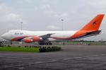
11.86Mb (501 downloads)
Kamair textures for the payware CLS Boeing 747-200
Posted Aug 10, 2013 13:17 by Rohullah
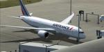
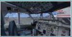
110.50Mb (3127 downloads)
FSX Boeing 787-8 Series Air France Package with VC for FSX
Model by TDS/ Tenkuu Developers Studio
with advanced 737-800 VC added.
The wonderful new Boeing 787-8 from TDS will be enjoyed by many more people who do not know how to install a VC into a FSX native model. So now the 787-8 has the nearest VC I can find -- the 737-800. The layout fof the 787 cockpit is not a million miles away from the advanced 737-800.
The VC is the Alejandro Rojas Lucena/FSND fantastic revised Boeing 737-800 VC model. This VC model includes Working wipers (right mouse click on switch) with rain effect. Switches for LCD Screens, EICAS, PFD, MFT. Autobrake switch. Opening pilots window. Cabin Lights switch. Realistic FMC. Ground Proximity Warning System (GPWS), More Realistic night VC textures. There are custom Boeing sounds included for that extra realism.
Air France textures by Giulio Catena.
Model is not modified in any way. Just the VC added and aircraft.cfg edited to allow correct VC views.
TDS wonderful native FSX Boeing 787-8 model. See VC docs to get the best out of the VC and FMC.
Assembled and prepared for FSX by Chris Evans.
Posted Aug 10, 2013 11:31 by Chris Evans
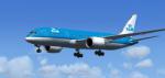

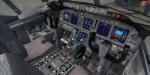
109.50Mb (5594 downloads)
FSX Boeing 787-8 Series KLM Package with VC for FSX
Model by TDS/ Tenkuu Developers Studio
with advanced 737-800 VC added.
The wonderful new Boeing 787-8 from TDS will be enjoyed by many more people who do not know how to install a VC into a FSX native model. So now the 787-8 has the nearest VC I can find -- the 737-800. The layout fof the 787 cockpit is not a million miles away from the advanced 737-800.
The VC is the Alejandro Rojas Lucena/FSND fantastic revised Boeing 737-800 VC model. This VC model includes Working wipers (right mouse click on switch) with rain effect. Switches for LCD Screens, EICAS, PFD, MFT. Autobrake switch. Opening pilots window. Cabin Lights switch. Realistic FMC. Ground Proximity Warning System (GPWS), More Realistic night VC textures. There are custom Boeing sounds included for that extra realism.
KLM textures by Giulio Catena.
Model is not modified in any way. Just the VC added and aircraft.cfg edited to allow correct VC views.
TDS wonderful native FSX Boeing 787-8 model. See VC docs to get the best out of the VC and FMC.
Assembled and prepared for FSX by Chris Evans.
Posted Aug 10, 2013 09:17 by Chris Evans
16.52Mb (18576 downloads)
Airbus A300-600ST Super Transporter 'Beluga' Airbus Industrie Package. Latest livery Repaint of Thomas Ruth's excellent model with VC, stairs and opening top section. (Ctrl-E, Ctrl-E-2, Ctrl-E-3.) Repaint by Stephen Browning
Posted Aug 10, 2013 07:05 by Stephen Browning
2.40Mb (1502 downloads)
For some reason or other Adventure, flying adventures to be exact, follow the paths of Max Rex, aviator an Gentleman class one. But this time he never expected to be called to possibly "save the world" as his new friend Dr. Ojuster assured him in front of a delicious dinner of stuffed pork and roasted duck in the jungle city of Iquitos in Peru. His lovely daughter looked with green eyes at the pilot as he heard the story her father was telling him...so amigo piloto, here is another chance for you to join the expedition but be aware that danger will be a passenger all the way!!!!!!
Posted Aug 9, 2013 21:35 by Gera Godoy Canova