


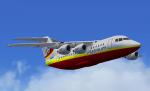
FSX > Page 1090
2.84Mb (513 downloads)
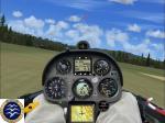
Try to get the so "convoited" Federation Aeronautique International glider badge and learn how a glider competition is accomplish.
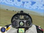
This is an FAI Gold Badge task for use with FSX and CumulusX!.
FAI Gold Badge task starts and ends at airfield Omarama (NZOA), for a course of 203 nautical miles. Weather is pretty good, ceiling is approx. 20 000 ft MSL, Time to complete will be around 4 hrs.
Features:
Chronometer timer, encouragement by your ground team at each event, message when Goals was achieve, Badge award at the end of the flight if you have reach all Goals badge rules.
Requirements:
* Wolgang Peper Rolladen-Schneider LS8-18 B21 * CumulusX! 1.9 Thermal software
* Simlogger v2.31 for register your flight
Posted Jul 29, 2013 09:02 by Ronald dandurand
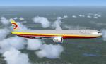
106.04Mb (5231 downloads)
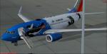
Boeing 737-700 Southwest Airlines 'Penguin One' with enhanced VC for FSX. Penguin One, of course, is not Southwest's first plane to bear a livery with ties to Sea World. The carrier's fleet also includes Shamu One and Shamu Two, which each feature likenesses of the famous SeaWorld whale. Penguin One becomes one of 13 current Southwest jets with unique paint schemes.
Model by Project Opensky
SWA 'Penguin One' painted by AJ Nikoley.
Model by Project Opensky/Skyspirit.
with advanced VC. Professional textures by Mathieu Vos.
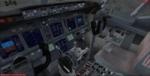
For Microsoft Flight Simulator X upgraded to FSX using Alejandro Rojas
Lucena/FSND fantastic revised Boeing 737-800 VC model. This VC model includes
Working wipers (right mouse click on switch) with rain effect. Switches for LCD
Screens, EICAS, PFD, MFT. Autobrake switch. Opening pilots window. Cabin Lights
switch. Realistic FMC. Ground Proximity Warning System (GPWS), More Realistic
night textures. Includes stairs (shift e 2). Also added jetway (Ctrl J) and there
are custom Boeing 737 sounds included for that extra realism. Thank you to AJ
Nikoley for his great repaint.
Skyspirit/Project Opensky wonderful native FSX Boeing 737-700 model included. See
VC docs to get the best out of the VC and FMC.
Assembled and prepared for FSX by Chris Evans.
Posted Jul 28, 2013 14:22 by Chris Evans
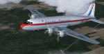
3.47Mb (353 downloads)
FS9/FSX Loide Aerio DC-4 (Brazil) textures only for the DC-4 package by Jens B. Kristensen. Textures by Gary Harper.
Required files:
required file
Posted Jul 28, 2013 12:18 by Gary Harper
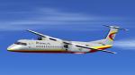
18.37Mb (4586 downloads)
Full model of the Bombardier Dash8-400Q in Platinum Airway's new
fleet, for FSX only. Platinum is an open-skies virtual airline for FSX, FS9,
and X-Plane. Visit us today at platinumairways.org. Paint by Jochen Schreeck, installer by Vic Ayers. No VC
Posted Jul 27, 2013 13:48 by Harrison B
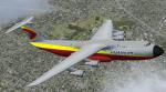
26.70Mb (2577 downloads)
Package includes: Full model of the Lockheed C-5A Galaxy in Platinum Airway's new fleet, for FSX only. Platinum is an open-skies virtual airline for FSX, FS9, and X-Plane. Visit us today at platinumairways.org. Model by Kazunori Ito, panel by Philippe Wallaert, sound by Christoffer Peterse, paint by Alwyn Neil, installer by Vic Ayers. 2d panel but no VC.
Posted Jul 27, 2013 13:43 by Harrison B
5.75Mb (2466 downloads)
ull model of the British Aerospace Bae-146-100 in
Platinum Airway's new fleet, for FSX only. Platinum is an open-skies virtual
airline for FSX, FS9, and X-Plane. Visit us today at platinumairways.org. Model by Premier Aircraft Design, paint by Alwyn Neil, installer by Vic Ayers.
Posted Jul 27, 2013 13:23 by Harrison B
48.52Mb (4727 downloads)
Full model of the Boeing 777-300ER in Platinum Airway's
new fleet, for FSX only. Platinum is an open-skies virtual airline for FSX,
FS9, and X-Plane. Visit us today at platinumairways.org. Model by POSKY, paint by Alwyn Neil, installer by Vic Ayers.
Posted Jul 27, 2013 13:21 by Harrison B
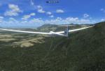
2.97Mb (502 downloads)
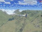
This is an FAI Diamond Badge task 500 km Distance at Seeley for use with FSX and CumulusX!.
FAI Diamond Badge task 500 km Distance starts at Seeley (23S) and ends at Golden (CYGE) airfield, for a course of 285 nautical miles. Weather is pretty good, ceiling is approx. 10 000 ft MSL. Time to complete will be around 5 hrs.
Features:
Chronometer timer, felicitation and encouragement by your ground team at each event, turn point, Start and finist line, message if you land out, message when Goals was acheive, Badge award at the end of the flight if you have reach all Goals rules.
Requirements:
* Wolgang Peper Rolladen-Schneider LS8-18 B21
* CumulusX! 1.9 Thermal software
* Simlogger v2.31 for register your flight
Posted Jul 27, 2013 12:55 by Ronald dandurand
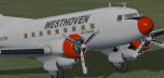
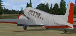
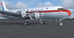
15.91Mb (480 downloads)
FSX Douglas C-117D repaint textures for Westhoven Air Transit N7379W,
for the freeware Manfred Jahn and team Douglas C-117D (c117d_v1_beta.zip),
which you must have previously installed in FSX. Repainted using Mr. Jahn's
Photoshop paint kit templates converted to bitmap and dds for compatibility
with freeware paint programs. Saved in 2048x2048 32bit. Also includes engine
exhaust smoke coordinates which you can add to your "aircraft.cfg" if you wish.
Screenshots enclosed. Easy installation. Repaint by Tom Tiedman.
Required files:
required file
Posted Jul 27, 2013 12:50 by Tom Tiedman
3.09Mb (542 downloads)
This is an FAI Silver Badge task at Aachen Merzbruck Germany, for use with FSX and CumulusX!.
FAI Silver Badge task starts and ends at airfield Aachen Merzbruck (EDKA), for a course of 127 nautical miles. Weather is pretty good, ceiling is approx. 6 300 ft MSL, average lift around 9 m/s. Time to complete will be around 2:30.
Features:
Chronometer timer, encouragement by your ground team at each event, turn point, Start and finist line, message if you land out, message when Goals was acheive, Badge award at the end of the flight if you have reach all Goals badge rules.
Requirements:
* Schleicher ASK 23 V1a B21 UK VGA
* CumulusX! 1.9 Thermal software
* Simlogger v2.31 for register your flight
Posted Jul 27, 2013 11:30 by Ronald dandurand