


FSX > Page 1221
6.62Mb (857 downloads)
Textures for the payware A2A/Aircraft Factory Albatros D.III (Oeffag) representing a scheme of por. Ludwik Patalas of 13.Eskadra Mysliwska (fighter sqn), Kisielevitche aerodrome, 1920.
Posted Sep 9, 2012 15:06 by Lukasz Kubacki
3.24Mb (2116 downloads)
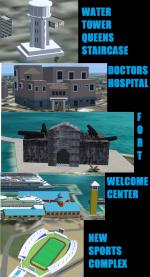
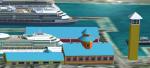
This is part 2 of the upgrade to Nassau Bahamas adding a few more landmarks to this islands scenery. This series of landmarks include Fort Montagu,Doctors Hospital(where Anna Nicole Smith's baby was born),The Water Tower at Queens Staircase, The Welcome Center for Cruise Ships and The Thomas A. Robinson Sports Complex.
Posted Sep 9, 2012 14:07 by Shawn Penn
-1.jpg-thumb.jpg)
-1.jpg-thumb.jpg)
78.08Mb (10509 downloads)
The Boeing 377, also called the Stratocruiser, was a large long-range airliner built after World War II. It was developed from the C-97 Stratofreighter, a military derivative of the B-29 Superfortress used for troop transport. The Stratocruiser's first flight was on July 8, 1947.
Named 'Stratocruiser' flying at FL300 with 114 passenger into 3.640nmi at M.55, only 50 were produced but this pack shows how it would be if it was 500 with 16 liverys, including new VC textures, gauges and realistic aircraft.cfg settings by ricardo_tv.
Model by Greg Pepper. Painted by ricardo_tv.
Liveries: Factory livery, United (by Dave McQueen); Aeroflot, Air France, American, BOAC, British Airways, Delta, Iberia, KLM, Lufthansa, Pan Am, Northwest, Scandinavian SAS and Qantas by ricardo_tv.
Enjoy making long flight with the Clipper of the seven seas.
Posted Sep 9, 2012 08:52 by ricardo_tv
3.02Mb (4323 downloads)
This program display information about some landing parameters. It may be used with default planes as well as thirty party developer aircrafts. At touchdown moment, the program displays parameters of the touchdown on simulator screen. The output is similar with ATIS messages line. Details information about the touchdown is written into two files one of these is simple HTML file and other is text table. This program is open source freeware product. You can modify the source code as you wish.
Posted Sep 9, 2012 08:34 by Alex Shag
0.05Mb (3837 downloads)
This Airport was updated by Google Maps and Airport Diagram. Adds lots of new Parking Spots and Runway Fixes. Place in Microsoft Flight Simulator X > Addon Scenery > Scenery Folder and restart FSX! Great For VATSIM. New Taxiway H added between 25L&R Airport
Posted Sep 8, 2012 12:09 by Delta2585
38.10Mb (17265 downloads)
This is a package assembled with some RAAF paints. Includes the default FSX Accelleration aircraft with VC. Requires FSX Acceleration. Textures include: 3SQN/77SQN/2 OCU 60th Anniversary/ RAAF 90th Anniversary/1 SQN (Fictional)
Posted Sep 8, 2012 05:15 by Tyler Boyd
124.56Mb (2247 downloads)
"imp" means imperfect, as other mesh I have already processed is of areas that have very little vegetation cover - over the land, or has large urban areas.
This "imp" mesh will include some slight discrepancies of altitude (in the case of forested areas - by a magnitude sometimes of +15 metres-depending on how tall the trees are, in the jungle or forest canopy) over urban areas, or areas with a lot of vegetation cover - due to the limitations of the ASTER satellites infra red scanning cameras, and the software used to process the DEM data.
Areas where there is little vegetation cover, or non urban areas, the terrain should have truer values.
But I feel this ASTER DEM data is so good - why let it all go to waste - especially flying over lovely Pacific islands?
So you FSX users out there will have to take all this into account when using this mesh.
Grateful thanks to ERSDAC, and NASA for making this data freely available to the public.
ASTER GDEM
Copyright (c) 2009 - 2011 Earth Remote Sensing Data Analysis Center (ERSDAC) All rights reserved.
ASTER GDEM is a product of METI and NASA.
Posted Sep 8, 2012 04:22 by Wayne Evans
20.68Mb (6135 downloads)
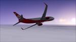
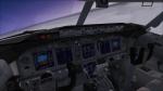
airberlin - Boeing 737-86J(WL)(D-ABKK). High quality FSX native model by Project Opensky. Includes the enhanced VC from Alejandro Rojas Lucena/FSND with GWPS, working wipers, FMC and more, for FSX.
Posted Sep 8, 2012 03:24 by Joel Stern
179.29Mb (2239 downloads)
"imp" means imperfect, as other mesh I have already processed is of areas that have very little vegetation cover - over the land, or has large urban areas.
This "imp" mesh will include some slight discrepancies of altitude (in the case of forested areas - by a magnitude sometimes of +15 metres-depending on how tall the trees are, in the jungle or forest canopy) over urban areas, or areas with a lot of vegetation cover - due to the limitations of the ASTER satellites infra red scanning cameras, and the software used to process the DEM data.
Areas where there is little vegetation cover, or non urban areas, the terrain should have truer values.
But I feel this ASTER DEM data is so good - why let it all go to waste - especially flying over lovely Pacific islands?
So you FSX users out there will have to take all this into account when using this mesh.
Grateful thanks to ERSDAC, and NASA for making this data freely available to the public.
ASTER GDEM
Copyright (c) 2009 - 2011 Earth Remote Sensing Data Analysis Center (ERSDAC) All rights reserved.
ASTER GDEM is a product of METI and NASA.
Posted Sep 8, 2012 03:13 by Wayne Evans
2.73Mb (262 downloads)
Tested on Windows XP and Windows 7.
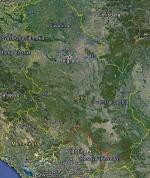
This download adds airfield markers and ICAO id's found in FSX, and overlays them on Google Earth.
This file is for Serbia & Montenegro.
There is also a seperate file with a list of basic airfield location details.
i.e: EGBB Birmingham Airport. Birmingham. N52* 27.23' W1* 44.88' alt325.
Also the tidying "My places" in Google Earth, file.
Other locator files to follow.
by Carl Vokes
Posted Sep 7, 2012 18:02 by carl vokes