


FSX > Page 1226
11.91Mb (2852 downloads)
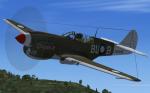
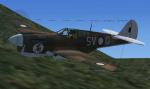
FSX/FS2004 Curtiss P-40M and P-40N
The Curtiss P-40 was undoubtedly one of the most controversial fighters to serve in quantity during the Second World War.
The P-40M, was a P-40E with a more powerful Allison engine , lenghtened fuselage and minor other improvements .
The P-40N, was the final production model. The P-40N featured a stretched rear fuselage to counter the torque of the larger,late-war Allison engine, and the rear deck of the cockpit behind the pilot was cut down at a moderate slant to improve rearward visibility. A great deal of work was also done to try and eliminate excess weight to improve the Warhawk's mediocre speed. Early N production blocks dropped a .50 in (12.7 mm) gun from each wing, bringing the total back to 4; later production blocks reintroduced it after complaints from units in the field.
GMAX mdls by A.F.Scrub
Posted Aug 31, 2012 18:03 by A.F.Scrub
40.80Mb (5399 downloads)
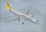
This is a repaint of the Project Airbus' A320-212 CFM in GermanWings livery. Panels for FSX and FS2009 included. VC for FSX, unworking in FS9. The indications for install the aircraft are easy. Four pictures are included.
Posted Aug 30, 2012 16:13 by Project Airbus/Stjepan Šikoronja/X
9.22Mb (2735 downloads)
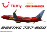
TUIfly Boeing 737-800WL in Cewe Fotobuch/"Cewe Air" livery, registration D-AHFZ. Highly detailed 32 bit textures. New photorealistic window textures and night textures. Model by Project Open Sky (Posky) and default B737-800 VC are included. By FSRepaintsGER / Benjamin Spranger.
Posted Aug 30, 2012 14:12 by FSRepaintsGER / Benjamin Spranger
0.90Mb (589 downloads)
"imp" means imperfect, as other mesh I have already processed is of areas that have very little vegetation cover - over the land, or has large urban areas.
This "imp" mesh will include some slight discrepancies of altitude (in the case of forested areas - by a magnitude sometimes of +15 metres-depending on how tall the trees are, in the jungle or forest canopy) over urban areas, or areas with a lot of vegetation cover - due to the limitations of the ASTER satellites infra red scanning cameras, and the software used to process the DEM data.
Areas where there is little vegetation cover, or non urban areas, the terrain should have truer values.
But I feel this ASTER DEM data is so good - why let it all go to waste - especially flying over lovely Pacific islands?
So you FSX users out there will have to take all this into account when using this mesh.
Grateful thanks to ERSDAC, and NASA for making this data freely available to the public.
ASTER GDEM
Copyright (c) 2009 - 2011 Earth Remote Sensing Data Analysis Center (ERSDAC) All rights reserved.
ASTER GDEM is a product of METI and NASA.
Posted Aug 30, 2012 03:16 by Wayne Evans
0.31Mb (929 downloads)
FSX cameras for the Mitsubishi Marquise from Premier Aircraft Design. This is a twin turbo-prop corporate and executive transport aircraft in the colours of the Lotus racing team (mu-2_g-ltus.zip). Of course my cameras can also been used for other FSX versions of the Mitsubishi MU from Premier Aircraft. The camera configuration provides 5 external and 5 internal extra views. Configuration by Erwin Welker
Required files:
required file
Posted Aug 29, 2012 11:44 by Erwin Welker
12.34Mb (1179 downloads)
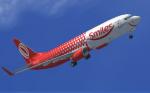
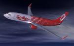
Textures for the default B737-800. Gol Transportes Aéreos is a Brazilian low-cost airline based in Paulo City, Brazil.
Established in 2000 it commenced operations in January 2001.
By March 2007 Gol had purchased part of the assets of VARIG Two years later
GOL was merged into VRG Linhas Aéreas.
The 2012 ‘Smile’ livery is a GOL promotion for using air miles towards travel payment.
Posted Aug 29, 2012 09:58 by Paul Davies
.jpg-thumb.jpg)
65.50Mb (2548 downloads)
So, there isn't any pack with Simviation old logo, so I thought I could make one, and there it is. This pack is for simviation and his owner that make possible to post this and my other works and Thomas, Alrot or FSND,... all are glad of the existence of this site.
So here we have the old Simviation textures pack.
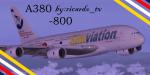
PA Airbus A380 plus Tom's VC update and new textures for VC and plane by ricardo_tv.
Enjoy
Posted Aug 29, 2012 09:24 by ricardo_tv
41.66Mb (1053 downloads)
So, there isn't any pack with the old Simviation logo, so I thought I could make one, and there it is. This pack is for Simviation and his owner that make possible to post this and my other works and many others... all are glad of the existence of this site.
Pack includes
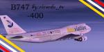
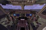
POSKY 747-400 plus FSND VC update by Alejandro, textures and update by ricardo_tv.
Enjoy
Posted Aug 29, 2012 09:23 by ricardo_tv
2.71Mb (438 downloads)
Tested on Windows XP and Windows 7.
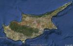
This download adds airfield markers and ICAO id's found in FSX, and overlays them on Google Earth.
This file is for Cyprus.
There is also a seperate file with a list of basic airfield location details.
i.e: EGBB Birmingham Airport. Birmingham. N52* 27.23' W1* 44.88' alt325.
Also the tidying "My places" in Google Earth, file.
Other locator files to follow.
by Carl Vokes
Posted Aug 28, 2012 16:07 by carl vokes
8.73Mb (10061 downloads)
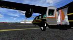
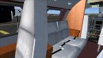
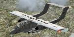
The Bronco is a twin turboprop light attack and observation aircraft. It was developed in the sixties and 370 units were built. Original model and textures by Tim Piglet. Adaptation to FSX, 2D (wide screen) panel and VC by Philippe Wallaert. See instructions for installation in the readme.txt file. Credits: Tim Piglet for the original model. Nice Flights!
Posted Aug 28, 2012 09:50 by Philippe Wallaert