


FSX > Page 1241
11.45Mb (5796 downloads)
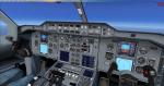
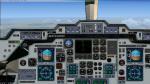
A remastered panel for the Tom Ruth A300-600 aircraft. Can also be used in the Tom Ruth A310 aircraft. Includes callouts and FMC.
Posted Jul 18, 2012 19:55 by Skilaeb Dygsbi
43.88Mb (816 downloads)
"imp" means imperfect, as other mesh I have already processed is of areas that have very little vegetation cover - over the land, or has large urban areas.
This "imp" mesh will include some slight discrepancies of altitude (in the case of forested areas - by a magnitude sometimes of +15 metres-depending on how tall the trees are, in the jungle or forest canopy) over urban areas, or areas with a lot of vegetation cover - due to the limitations of the ASTER satellites infra red scanning cameras, and the software used to process the DEM data.
Areas where there is little vegetation cover, or non urban areas, the terrain should have truer values.
But I feel this ASTER DEM data is so good - why let it all go to waste - especially flying over lovely Pacific islands?
So you FSX users out there will have to take all this into account when using this mesh.
Grateful thanks to ERSDAC, and NASA for making this data freely available to the public.
ASTER GDEM
Copyright (c) 2009 - 2011 Earth Remote Sensing Data Analysis Center (ERSDAC) All rights reserved.
ASTER GDEM is a product of METI and NASA.
Posted Jul 18, 2012 19:22 by Wayne Evans
15.35Mb (599 downloads)
"imp" means imperfect, as other mesh I have already processed is of areas that have very little vegetation cover - over the land, or has large urban areas.
This "imp" mesh will include some slight discrepancies of altitude (in the case of forested areas - by a magnitude sometimes of +15 metres-depending on how tall the trees are, in the jungle or forest canopy) over urban areas, or areas with a lot of vegetation cover - due to the limitations of the ASTER satellites infra red scanning cameras, and the software used to process the DEM data.
Areas where there is little vegetation cover, or non urban areas, the terrain should have truer values.
But I feel this ASTER DEM data is so good - why let it all go to waste - especially flying over lovely Pacific islands?
So you FSX users out there will have to take all this into account when using this mesh.
Grateful thanks to ERSDAC, and NASA for making this data freely available to the public.
ASTER GDEM
Copyright (c) 2009 - 2011 Earth Remote Sensing Data Analysis Center (ERSDAC) All rights reserved.
ASTER GDEM is a product of METI and NASA.
Posted Jul 18, 2012 09:14 by Wayne Evans
3.82Mb (4453 downloads)
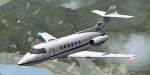
Royal Air Force HS 125. This aircraft is one of the first business jet and was also used by the army. A bit more than 1000 units have been delivered under a lot of versions and many of them are steel flying. This version is the one with the latest avionics. Credits: Henry Tomkiewicz for the original model. Panel (no VC), textures and adaptation to FSX by Philippe Wallaert. See instructions for configuration in the readme.txt file. Nice flights!
Posted Jul 18, 2012 07:38 by Philippe Wallaert
16.17Mb (492 downloads)
"imp" means imperfect, as other mesh I have already processed is of areas that have very little vegetation cover - over the land, or has large urban areas.
This "imp" mesh will include some slight discrepancies of altitude (in the case of forested areas - by a magnitude sometimes of +15 metres-depending on how tall the trees are, in the jungle or forest canopy) over urban areas, or areas with a lot of vegetation cover - due to the limitations of the ASTER satellites infra red scanning cameras, and the software used to process the DEM data.
Areas where there is little vegetation cover, or non urban areas, the terrain should have truer values.
But I feel this ASTER DEM data is so good - why let it all go to waste - especially flying over lovely Pacific islands?
So you FSX users out there will have to take all this into account when using this mesh.
Grateful thanks to ERSDAC, and NASA for making this data freely available to the public.
ASTER GDEM
Copyright (c) 2009 - 2011 Earth Remote Sensing Data Analysis Center (ERSDAC) All rights reserved.
ASTER GDEM is a product of METI and NASA.
Posted Jul 18, 2012 06:51 by Wayne Evans

512.26Mb (48412 downloads)
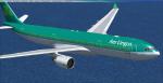
The Volume 1 of the Airbus A330 Multi-Livery Mega-Package contains all the A330 variants (-200, -200F, -300, -MRTT) Models and Virtual Cockpits created by Thomas Ruth, 65 Good-Quality Liveries, custom soundsets for the GE-CF6, PW4000 and RR700 engines created by Andre Silva and Emil Serafino (who gave me his permission to use his soundsets), a fully edited aircraft.cfg with 27 custom-made views and jetway & cargo-truck codes included, gauges for the Flight Management Computer (FMC), Ground Proximity Warning System (GPWS) and AutoBrake systems created by dfferent authors and a lot of dedication. For a detailed explanation in English & Spanish, a list of liveries and some pictures, visit my blog at: http://fsxluchoals.blogspot.com/
Posted Jul 18, 2012 04:05 by Luis Quintero
3.58Mb (736 downloads)
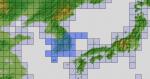
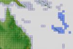
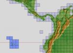
ASTER GDEM Version 2 is a 30 metre definition DEM, its better than the version 1 data that ERSDAC, of Japan and NASA originally released, but it does have its limitations.
GDEM has been obtained from a satellite that uses stereoscopic infrared scanning cameras, this brings with it problems in the resultant data.....where it sees the tops of trees, buildings etc, as the ground terrain.
If you look at the jpg image with the terrain type errors shown as a graph, you will see that the only 'safe' terrain to use this data with - in FSX - is scrubland, or desert terrain.
Its hopeless in defining the terrain in places like Europe - with all the artificial structures, (buildings) and different types of woodland, so any mesh I create from this data won't include areas like that....it will be more desert type terrain, and scrubland.
I won't be doing Greenland because something about the ice around Greenland, (or any other land mass with ice) it creates false data.
It does give enough fine data to reveal railway lines, and some roads though.
This mesh has been made for FSX only.
Grateful thanks to ERSDAC, and NASA for making this data freely available to the public.
ASTER GDEM
Copyright (c) 2009 - 2011 Earth Remote Sensing Data Analysis Center (ERSDAC) All rights reserved.
ASTER GDEM is a product of METI and NASA.
Posted Jul 18, 2012 04:04 by Wayne Evans
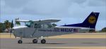
6.27Mb (2991 downloads)
Lufthansa Training textures for the default FSX Cessna Skyhawk 172SP
Posted Jul 18, 2012 03:00 by Jim Fly


336.33Mb (23541 downloads)
The Volume 2 of the Airbus A330 Multi-Livery Mega-Package contains all the A330 variants (-200, & -300) Models created by The Project Opensky Team, 42 High-Quality Liveries, custom soundsets for the GE-CF6, PW4000 and RR700 engines created by Andre Silva and Emil Serafino (who gave me his permission to use his soundsets), a fully edited aircraft.cfg with a lot of corrections and bugs fixed, 27 custom-made views and jetway & cargo-truck codes included, gauges for the Flight Management Computer (FMC), Ground Proximity Warning System (GPWS) and AutoBrake systems created by dfferent authors and a lot of dedication. For a detailed explanation in English & Spanish, a list of liveries and some pictures, visit my blog at: http://fsxluchoals.blogspot.com/
Posted Jul 18, 2012 02:58 by Luis Quintero
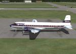
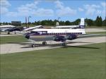
3.17Mb (911 downloads)
FS9/FSX JBK DELTA DC-6 textures circa 1959.
Requires dc6_v20.zip for FS9 or dc6_v20x.zip for FSX.
Model by Jens Christensen. Textures by Gary Harper.
Posted Jul 18, 2012 00:38 by Gary Harper