


FSX > Page 1292
25.15Mb (1149 downloads)
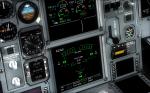
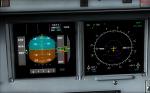
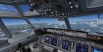
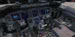
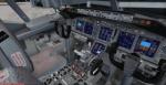
Overland SMS has a popular large Airbus series. With this package their A330 receives a gauges upgrade.
Posted Apr 18, 2012 19:11 by Dimitrios Moschos
3.21Mb (1814 downloads)
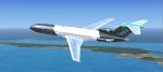
This is a 727 in Black Bahamasair fictional livery. Model by Vistaliners / Eric Cantu and painted by BahamasFlyers. Uses default B737 2d panel. No VC.
Posted Apr 18, 2012 16:34 by Shawn Penn
-1.jpg-thumb.jpg)
-1.jpg-thumb.jpg)
3.37Mb (2740 downloads)
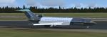
This is a Laker 727 in Bahamian Princess aka Grand Bahama Island Livery in honor of the Princess Casino in Freeport, Bahamas.Featured on this 727 are as follow: Rear Airstair (wing unfold key) Jetway compatibility, pull up to a gate and press(Ctrl+J)the jetway slowly approaches the plane for connection. Model by Vistaliners / Eric Cantu and painted by BahamasFlyers. Uses default B737 2d panel. No VC.
Posted Apr 18, 2012 16:25 by Shawn Penn

28.17Mb (2641 downloads)
North American Airlines (NAA) Boeing 767-300ER painted on SkySpirit2010's Boeing 767-300 V5 aircraft. North American Airlines currenly operate 5 B767-300's.
Upgraded to FSX using Alrot's revised Boeing 737-800 VC. This model includes Working wipers (right mouse click on switch) with rain effect. Switches for LCD Screens, EICAS, PFD, MFT. Autobrake switch. Opening pilots window. Cabin Lights switch. Realistic FMC. Ground Proximity Warning System (GPWS), More Realistic night textures. Model features High resolution textures, Dynamic flexing wings, Body gear steering, Nose gear steering, Rudder lock, Ground spoilers, Low speed aileron locks at high speed, Fully animated control surfaces, Fully independent suspension, Trim Animation, Opening Passenger Doors, Animated tilting bogies, Rolling wheels, Animated thrust reverser's with reverser block doors, Detailed textures, Full night lighting, Crash affects, Ground Service Vehicles And more. Model Designer Hiroshi Igami/Yosuke Ube. Flight Dynamics Designer Warren C. Daniel. Master Base Textures:
Philip Foglar.
FSX native model by Skyspirit/Project Opensky. VC by Alejandro Rojas Lucena (Alrot).
Textures by Steve McBee.
Modified for FSX by Chris Evans.
Posted Apr 18, 2012 07:24 by Chris Evans
45.42Mb (1349 downloads)
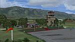
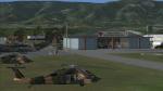
Regional airport located to the west of San Felipe city.
Used for both military and civilian aircraft, works
only for private flights and small-scale aircraft.
With photo-terrain scenery from satellite imagery
of Yahoo Satellite.
Not compatible with versions prior to FSX.
This scenery includes terminal building and hangars with realistic
textures from images obtained from Internet.
Also includes a friendly Auto-Install.
Posted Apr 17, 2012 20:47 by David Maldonado
29.90Mb (9411 downloads)
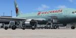
Air Canada Boeing 767-300ER C-FOCA painted on SkySpirit2010's Boeing 767-300 V5 aircraft.
Upgraded to FSX using Alrot's revised Boeing 737-800 VC. This model includes Working wipers (right mouse click on switch) with rain effect. Switches for LCD Screens, EICAS, PFD, MFT. Autobrake switch. Opening pilots window. Cabin Lights switch. Realistic FMC. Ground Proximity Warning System (GPWS), More Realistic night textures. Model features High resolution textures, Dynamic flexing wings, Body gear steering, Nose gear steering, Rudder lock, Ground spoilers, Low speed aileron locks at high speed, Fully animated control surfaces, Fully independent suspension, Trim Animation, Opening Passenger Doors, Animated tilting bogies, Rolling wheels, Animated thrust reverser's with reverser block doors, Detailed textures, Full night lighting, Crash affects, Ground Service Vehicles And more. Model Designer Hiroshi Igami/Yosuke Ube. Flight Dynamics Designer Warren C. Daniel. Master Base Textures:
Philip Foglar.
FSX native model by Skyspirit/Project Opensky. VC by Alejandro Rojas Lucena (Alrot).
Livery by Carlos Eduardo Salas.
Modified for FSX by Chris Evans.
Posted Apr 17, 2012 09:24 by Chris Evans
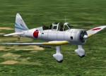
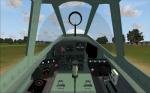
8.85Mb (2408 downloads)
Tachikawa Ki-36 type98 (Ida), Japanese WW2 trainer and reconnaissance aircraft, originally made for CFS2 by Thicko, now flyable in FSX with acceptable VC. Thanks again Thicko for your great work!
Unfortunately the opening and closing of the reargunner’s cockpit and him getting in position doesn’t work in my version of FSX Acceleration, though I have made settings for the Concorde’s nose visor extend and retract control keys. In FS9 it works fine. If anybody knows a solution for it I would be happy to know.
The aircraft is flying very well in my versions of FSX-Acceleration and FS9, but is not tested by me in SP1 or SP2. This file should not harm your computer, but I accept no responsibility when it does, so try it at your own risk. Remarks and hints are welcome. Have fun!
Posted Apr 17, 2012 09:21 by Erik Hertzberger
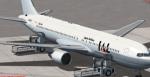
26.06Mb (4738 downloads)
Boeing 767-300/ER Japan Airlines (80's-2000's) JA8264 painted on SkySpirit2010's Boeing 767-300 V5 aircraft.
Upgraded to FSX using Alrot's revised Boeing 737-800 VC. This model includes Working wipers (right mouse click on switch) with rain effect. Switches for LCD Screens, EICAS, PFD, MFT. Autobrake switch. Opening pilots window. Cabin Lights switch. Realistic FMC. Ground Proximity Warning System (GPWS), More Realistic night textures. Model features High resolution textures, Dynamic flexing wings, Body gear steering, Nose gear steering, Rudder lock, Ground spoilers, Low speed aileron locks at high speed, Fully animated control surfaces, Fully independent suspension, Trim Animation, Opening Passenger Doors, Animated tilting bogies, Rolling wheels, Animated thrust reverser's with reverser block doors, Detailed textures, Full night lighting, Crash affects, Ground Service Vehicles And more. Model Designer Hiroshi Igami/Yosuke Ube. Flight Dynamics Designer Warren C. Daniel. Master Base Textures:
Philip Foglar.
FSX native model by Skyspirit/Project Opensky. VC by Alejandro Rojas Lucena (Alrot).
Livery by Febriant Leocesio.
Modified for FSX by Chris Evans.
Posted Apr 17, 2012 08:34 by Chris Evans
188.71Mb (777 downloads)
There are Eighteen (18) parts of this mesh to download as separate files.
ASTER GDEM Version 2 is a 30 metre definition DEM, its better than the version 1 data that ERSDAC, of Japan and NASA originally released, but it does have its limitations.
GDEM has been obtained from a satellite that uses stereoscopic infrared scanning cameras, this brings with it problems in the resultant data.....where it sees the tops of trees, buildings etc, as the ground terrain.
If you look at the jpg image with the terrain type errors shown as a graph, you will see that the only 'safe' terrain to use this data with - in FSX - is scrubland, or desert terrain.
Its hopeless in defining the terrain in places like Europe - with all the artificial structures, (buildings) and different types of woodland, so any mesh I create from this data won't include areas like that....it will be more desert type terrain, and scrubland.
I won't be doing Greenland because something about the ice around Greenland, (or any other land mass with ice) it creates false data.
It does give enough fine data to reveal railway lines, and some roads though.
This mesh has been made for FSX only.
Grateful thanks to ERSDAC, and NASA for making this data freely available to the public.
ASTER GDEM
Copyright (c) 2009 - 2011 Earth Remote Sensing Data Analysis Center (ERSDAC) All rights reserved.
ASTER GDEM is a product of METI and NASA.
Posted Apr 17, 2012 06:53 by Wayne Evans

208.48Mb (392 downloads)
There are Eighteen (18) parts of this mesh to download as separate files.
ASTER GDEM Version 2 is a 30 metre definition DEM, its better than the version 1 data that ERSDAC, of Japan and NASA originally released, but it does have its limitations.
GDEM has been obtained from a satellite that uses stereoscopic infrared scanning cameras, this brings with it problems in the resultant data.....where it sees the tops of trees, buildings etc, as the ground terrain.
If you look at the jpg image with the terrain type errors shown as a graph, you will see that the only 'safe' terrain to use this data with - in FSX - is scrubland, or desert terrain.
Its hopeless in defining the terrain in places like Europe - with all the artificial structures, (buildings) and different types of woodland, so any mesh I create from this data won't include areas like that....it will be more desert type terrain, and scrubland.
I won't be doing Greenland because something about the ice around Greenland, (or any other land mass with ice) it creates false data.
It does give enough fine data to reveal railway lines, and some roads though.
This mesh has been made for FSX only.
Grateful thanks to ERSDAC, and NASA for making this data freely available to the public.
ASTER GDEM
Copyright (c) 2009 - 2011 Earth Remote Sensing Data Analysis Center (ERSDAC) All rights reserved.
ASTER GDEM is a product of METI and NASA.
Posted Apr 17, 2012 05:45 by Wayne Evans