


FSX > Page 1635
3.49Mb (1172 downloads)
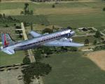
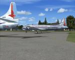
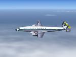
FSX/FS9 Eastern Airlines textures for JBK DC-4 V2.
Requires DC4_V21.zip by Jens Kristensen. Textures by Gary Harper.
These textures depict an Eastern DC-4 about 1954.
Required files:
required file
Posted Jun 11, 2010 00:01 by Gary Harper

0.79Mb (6024 downloads)
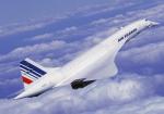
This is a mission of an historical nature. If you have ever flown in the Concorde of admire it like me, you will enjoy this mission. If have recreated a fictional race to watch the World Cup Soccer France-Uruguay Saterday 12 June 2010 on 08:30pm South African Time.
Posted Jun 10, 2010 17:13 by Robbie Albers

9.40Mb (443 downloads)
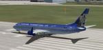
Textures only for the FSX default 737-800. The two flagships of the fictional Fletcher International Air, the "Lady Jessica" and the "Jane Doe."
Posted Jun 10, 2010 11:19 by Chaz
6.76Mb (1404 downloads)
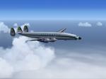
L1649A Lufthansa 'Super Star' D-ALAN in delivery paint scheme of 1957. Textures only. It was the Lufthansa Flagship for a while and once did a trip around the world on a government mission. 'D-ALAN' is now preserved in the 'Fame of Flight Museum' at Polk City, FL, USA as one out of four surviving 'Starliners'.
Required files:
required file
Posted Jun 10, 2010 02:27 by Joachim Liethen
0.02Mb (2540 downloads)
An update for three airports in Arizona where boneyards for scrapworthy airplanes are located. Includes Phoenix-Goodyear, Kingman, and Marana-Pinal County.
Posted Jun 9, 2010 20:37 by Erik Ingram
5.44Mb (12053 downloads)
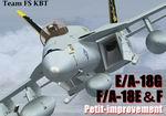
Team FS KBT
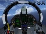
FA-18E,F and EA-18G
FSX Update.
The team has improved FA18 a little.
It is not an entire version that has already been released. The flicker of black VC view and a part of texture etc. by FSX have been improved though it is limited models.
It roughly suits fsx.
Posted Jun 9, 2010 10:10 by Team KBT
5.19Mb (2398 downloads)
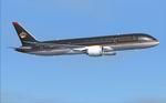
FSX Royal Jordanian Boeing 787-8 V2, This CamSim Version 2 feature an improve aircraft's design with new Animated Ground Servicing (AGS).
Model design and paint by Camil Valiquette.
Posted Jun 9, 2010 10:04 by Camil Valiquette
2.17Mb (8542 downloads)
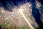
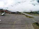
Approach to Lukla V2 (Totally New Mission) You are a very experienced pilot flying the Twin Otter for Yeti Airlines on an imaginary flight to and from Lukla. Take-off from Biratnagar airport VNVT climb to at least 13500 ft to WP1 Turn to Lukla. From WP1 carefully descent to 10000 ft (there should be cloud to make it more difficult, if you have some sort of weather add-on running) to WP2 Approach to VNLK, after passing through the gate turn sharp right and land at Lukla airport, remember that the runway has an incline of several degrees. Turn around and take-off again, stay on the runway and rotate just before the end of the runway. Follow the valley back to the south until you are able to track the VOR 112.30 at roughly 276 degrees, till you reach Kathmandu Intl Airport and land. Yes, it sounds easy, but .. find out for yourself.
Posted Jun 8, 2010 15:33 by Robbie Albers
.jpg-thumb.jpg)
15.05Mb (5021 downloads)
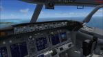
Project Opensky Boeing 737-700 Luxair old livery, with wirtual cockpit included.
Posted Jun 8, 2010 13:14 by Jesse Cruz

69.12Mb (7095 downloads)
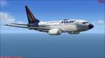
Project Opensky Boeing 737-600 Malev Hungarian Airlines. With virtual cockpit included.
Posted Jun 8, 2010 12:56 by Jesse Cruz