


FSX > Page 1660
3.60Mb (5728 downloads)
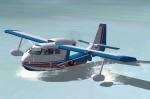
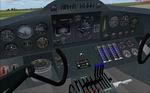
Republic RC-3 "SuperBee" Amphibian
This is the famous Republic SeaBee with performance modifications. Lycoming GO-480 315 hp engine, 3 blade fully reversible Hartzell propeller, wing tip extensions.
Complete package for FSX/SP2 with full moving parts, 2D and VC panel, check and ref lists. A real
fun plane, flies and floats beautifully.
By Jean-Pierre Brisard and Bob May - Premier Aircraft Design.
Posted Apr 19, 2010 06:11 by bob.may@premaircraft.com
7.07Mb (7947 downloads)
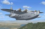
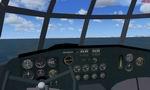
FSX Short Hythe. The Short Hythe was a civil conversion of the Short Sunderland III patrol flying boat of WW2 fame. A number of Sunderlands served BOAC from 1943, and 22 of them were converted to proper airlines in 1946. Many of them were taken over by Aquila Airways in 1948-49, and served into the 1950's. VC included. For FSX only, FS2004 users should download Hythe_V10.zip instead. By Jens B. Kristensen
Posted Apr 18, 2010 07:12 by Jens B. Kristensen
13.88Mb (10255 downloads)
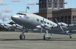
FSX De Havilland DH.91 Albatross. A beautiful, 4-engined British airliner of 1938, used by Imperial Airways and BOAC. Predecessor of the famous DH.98 Mosquito fighter-bomber of WW2. Version 3 model, with more accurate panel and virtual cockpit, and other improvements. For FSX only, FS2004 users should download DH91_V30.zip instead. By Jens B. Includes VC. Kristensen
Posted Apr 18, 2010 07:04 by Jens B. Kristensen
0.92Mb (11477 downloads)
The package contains an in-flight refueling gauge that can be installed on any aircraft and allows refueling in the air from any aircraft - in free flight or multiplayer. By Andy Niko and Jivko Rusev.
Posted Apr 17, 2010 19:30 by Jivko Rusev
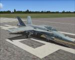
3.65Mb (1016 downloads)
Argentine Textures only for the default FSX Acceleration FA-18 Hornet
Posted Apr 17, 2010 17:28 by Juan Ramiro Franceschini
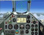
1.85Mb (3642 downloads)
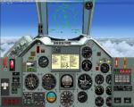
Photorealistic 2 D panel for the Dassault/Dornier Alphajet. All original gauges in xml. You can use this panel with this excellent model:
http://www.simviation.com/simviation/static.php?ID=64&page=21
Please see instructions in the readme.txt for installation and configuration.
Required files:
required file
Posted Apr 17, 2010 11:20 by Philippe Wallaert
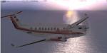
2.83Mb (1273 downloads)
Kingair 350 Red Airlines Textures only for the default kingair 350.
Posted Apr 16, 2010 21:28 by DONZ
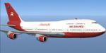
1.77Mb (1863 downloads)
Boeing 747-400 Red Airlines Textures only for the default FSX B747.
Posted Apr 16, 2010 21:23 by DONZ
5.29Mb (825 downloads)
This is a try to put Basel-Mulhouse-Freiburg (LFSB) into FSX.
It's not finished and a long way to go.
Posted Apr 16, 2010 10:40 by Othmar Egli
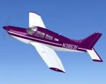
2.94Mb (847 downloads)
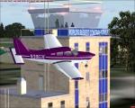
FSX Purple Piper PA28R201 Arrow. Repaint textures only for Hauke Keitel's Freeware Piper PA28R201 Arrow which you must have previously installed. A plethora of polished purple pipertude pleasuring pilots by profoundly provoking wide-eyed wonder and ear to ear grins. Oh happy joy! Repaint by Tom Tiedman
Required files:
required file
Posted Apr 16, 2010 06:53 by Tom Tiedman