


FSX > Page 1775
1.40Mb (8648 downloads)
FSX
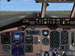
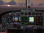
MD80 Panel.
Made by Marco Spada using an original bitmap and assembling
default and various author's xml gauges. 1.4MB
Fix
for MD80 Panel.
Updated "panel.cfg" file to fix ASI Airspeed non
working correctly with some MD80/83 flight models like FFX/SGA.
3K
Posted Sep 10, 2009 06:47 by archive
1.71Mb (5369 downloads)
FSX
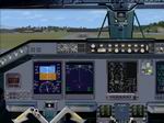
Embraer ERJ 170 panel.
Original bitmap and gauge artwork by Marco Spada. Uses only
default fsx gauges. Marco Spada. 1.7MB
Posted Sep 10, 2009 06:47 by archive
8.86Mb (4034 downloads)
FSX
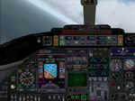
Generic Twin Business Jet Panel.
Could be used for many light twin jets. Autopilot, etc all work,
Required FSUIP here. Jim"Pappy"
Welch from an original Bitmap. 9.2MB
Posted Sep 10, 2009 06:47 by archive
0.93Mb (2983 downloads)
FSX
2D Cessna C208 Caravan Panel.
Designed from a real photo as replacement for the default FSX
C208. XML gauges from MSFSX (just one slightly modified). No
change at all for 3D panel. By Pierre Fasseaux. 954K
Posted Sep 10, 2009 06:47 by archive
9.53Mb (5193 downloads)
FSX
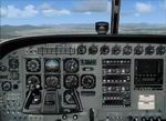
Cessna 421 Panel.
You can use this panel for any twin engine piston plane. I have
no idea where all of the gauges came from, except one, that
is the f-16 radar by Eric Marchiano. To make this gauge work,
you must have a copy of fsuip (here)
either registered or non registered. Jim "pappy" Welch.
9.7MB
Posted Sep 10, 2009 06:47 by archive
50.23Mb (6806 downloads)
Miramar, Oceana, Pensacola U.S., and Yokosuka, Japan Carrier Scenerys V5.0
Updated with (Javier Fernandez) s High Detail Carriers.
Good scenery for organized multiplayer carrier circuits and traps, all players will see these.
Ships spaced out to address a common frame rate complaint. Has locializer, dme, Arrestor cables.
NDB on decks for ADF head wind approuches.
Use Arrestor Cables V2.6 for Catapults.
ALL credits due for carrier's to Javier Fernandez
Posted Sep 10, 2009 03:44 by T.Marson/Thunder
.jpg-thumb.jpg)
0.89Mb (1887 downloads)
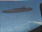
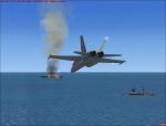
Updated OLD SCENERY (3 GPS oil platforms V4.0) 3 mission Oil Platforms. Included a Oil tanker ship multiplayer mission scenery, the tanker is on fire with 2 Coast Guard cutters near itrnfor rescue. Open ended mission scenery for what ever scenario you come up with, Location is in read me. And I've marked the stock Oil platforms around the United states and Mexico with GPS tags, rnNDB, and VOR for navigation. Going to add more countrys stock oil platforms navigation locations in updates to come. All Platforms NDB"s are on helo deck.
Posted Sep 10, 2009 03:04 by T.Marsom/Thunder
2.25Mb (1352 downloads)
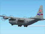
You have purchase the Captain Sim C-130 for these textures. This textures is Youngstown Oh, ARS 910th AW C-130 Located at (KYNG) Made By Le'Will Brown (Vapor) 1st Time Painting an aircraft. No one Had these textures, and i wanted it so bad so I figured I'd make it and shared it with the people who has the Captain Sim C-130. Enjoy. Made by Le'Will Brown (Vapor)
Posted Sep 10, 2009 00:45 by Le'Will Brown
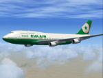
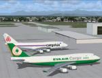
3.97Mb (10583 downloads)
FSX Boeing 747-400 EVA Air Textures. Registration: B-16403. Textures only for the default FSX B747-400. A little surprise: EVA Air Cargo Textures. Registration: B-16481. And the usual bonus from me: EVA Air and EVA Air Cargo B747-400 traffic package included. Created by Gabor Kovacs
Posted Sep 9, 2009 12:56 by Gabor Kovacs
13.37Mb (3768 downloads)
FSadventureSky's Mini-Mission--or "Quicky Flight of the day"... --Flying from Kosice to Tatry is a daily affair for Capt. Gorky Trusky. Each morning he gets up at 5:00 am has his frozen Rouka egg breakfast(?), gets into his moped and drives to the airport. After kicking the tires of the old AN-26 he plays with "piktu" the airport dog , checks on Milia the company secretary then gets into his aircraft's seat to start his daily chore. Today is raining pretty hard and there are many thunderstorms on route.He will not be flying today since he is going fishing at lake Gulyku with Petrosk his boss and partner in drinking habits. So,You are flying today as captain of the flight, with Katrina and Shasha as assistants..
Posted Sep 9, 2009 11:46 by Gera Godoy Canova